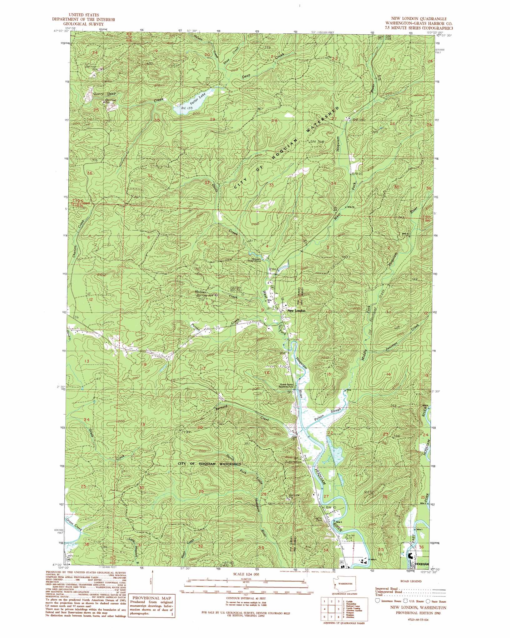
New London Topo Map Washington
To zoom in, hover over the map of New London
USGS Topo Quad 47123a8 - 1:24,000 scale
| Topo Map Name: | New London |
| USGS Topo Quad ID: | 47123a8 |
| Print Size: | ca. 21 1/4" wide x 27" high |
| Southeast Coordinates: | 47° N latitude / 123.875° W longitude |
| Map Center Coordinates: | 47.0625° N latitude / 123.9375° W longitude |
| U.S. State: | WA |
| Filename: | o47123a8.jpg |
| Download Map JPG Image: | New London topo map 1:24,000 scale |
| Map Type: | Topographic |
| Topo Series: | 7.5´ |
| Map Scale: | 1:24,000 |
| Source of Map Images: | United States Geological Survey (USGS) |
| Alternate Map Versions: |
New London WA 1990, updated 1990 Download PDF Buy paper map New London WA 2011 Download PDF Buy paper map New London WA 2014 Download PDF Buy paper map |
1:24,000 Topo Quads surrounding New London
Shale Slough |
Macafee Hill |
Stevens Creek |
Burnt Hill |
Larsen Creek |
Moclips |
Carlisle |
Humptulips |
Railroad Camp |
Wynoochee Valley Nw |
Copalis Beach |
Copalis Crossing |
New London |
Aberdeen Gardens |
Wynoochee Valley Sw |
Point Brown |
Westport |
Hoquiam |
Aberdeen |
Central Park |
Grayland |
Western |
Aberdeen Se |
Elkhorn Creek |
> Back to 47123a1 at 1:100,000 scale
> Back to 47122a1 at 1:250,000 scale
> Back to U.S. Topo Maps home
New London topo map: Gazetteer
New London: Dams
Davis Creek Dam elevation 13m 42′Failor Lake Dam elevation 47m 154′
New London: Populated Places
New London elevation 7m 22′Woodlawn elevation 11m 36′
New London: Reservoirs
Failor Lake elevation 78m 255′Failor Lake elevation 47m 154′
Hoquiam Water Works elevation 13m 42′
New London: Streams
Bernard Creek elevation 4m 13′Davis Creek elevation 11m 36′
Hooner Creek elevation 9m 29′
Junction Creek elevation 10m 32′
Middle Fork Hoquiam River elevation 4m 13′
Nelson Creek elevation 53m 173′
Polson Creek elevation 7m 22′
Polson Slough elevation 4m 13′
Shaw Creek elevation 55m 180′
West Fork Hoquiam River elevation 6m 19′
New London digital topo map on disk
Buy this New London topo map showing relief, roads, GPS coordinates and other geographical features, as a high-resolution digital map file on DVD: