Eyraud Lakes Topo Map Montana
To zoom in, hover over the map of Eyraud Lakes
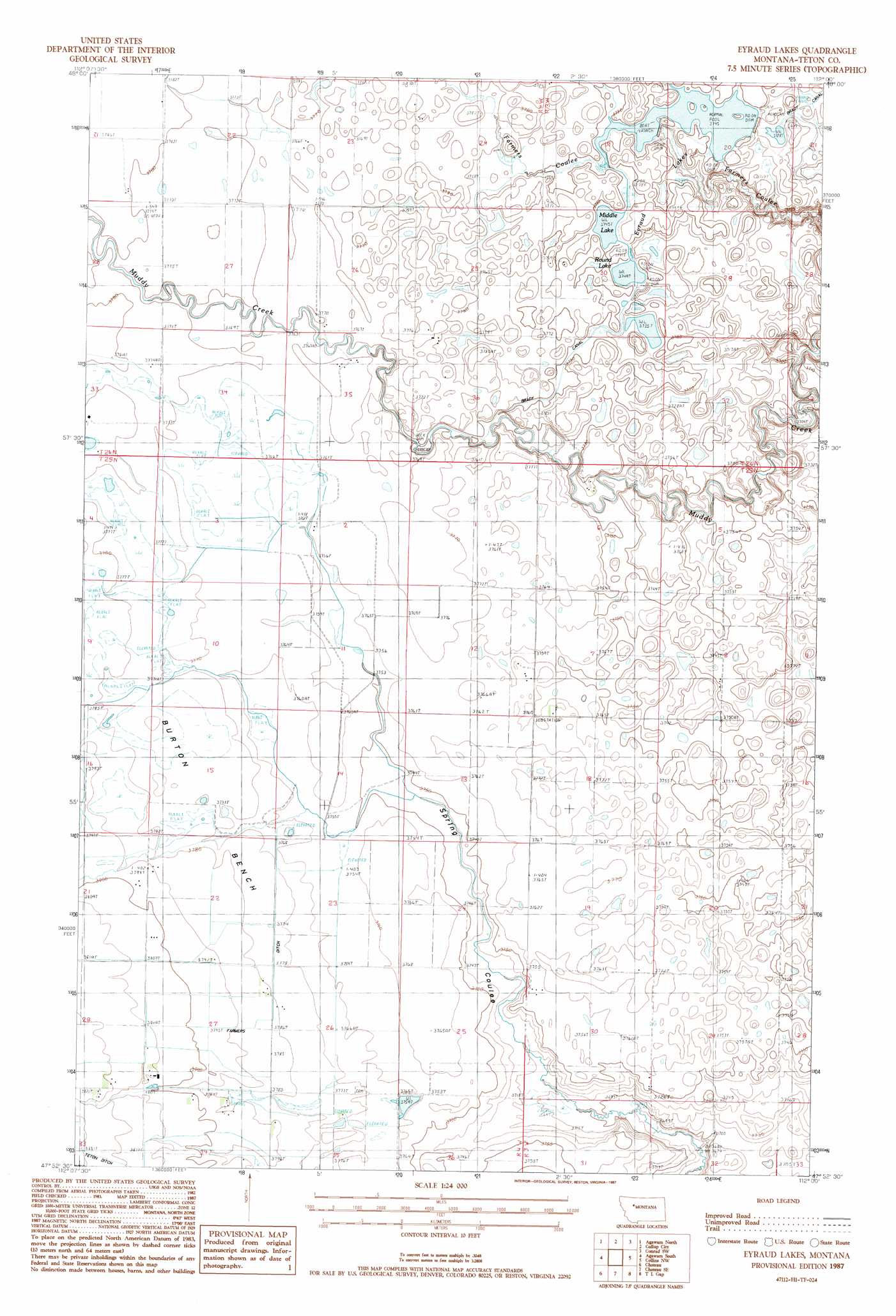
USGS Topo Quad 47112h1 - 1:24,000 scale
| Topo Map Name: | Eyraud Lakes |
| USGS Topo Quad ID: | 47112h1 |
| Print Size: | ca. 21 1/4" wide x 27" high |
| Southeast Coordinates: | 47.875° N latitude / 112° W longitude |
| Map Center Coordinates: | 47.9375° N latitude / 112.0625° W longitude |
| U.S. State: | MT |
| Filename: | o47112h1.jpg |
| Download Map JPG Image: | Eyraud Lakes topo map 1:24,000 scale |
| Map Type: | Topographic |
| Topo Series: | 7.5´ |
| Map Scale: | 1:24,000 |
| Source of Map Images: | United States Geological Survey (USGS) |
| Alternate Map Versions: |
Eyraud Lakes MT 1987, updated 1987 Download PDF Buy paper map Eyraud Lakes MT 2011 Download PDF Buy paper map Eyraud Lakes MT 2014 Download PDF Buy paper map |
1:24,000 Topo Quads surrounding Eyraud Lakes
Lone Man Coulee West |
Lone Man Coulee East |
Sam George Hill |
Conrad |
Letz Lake |
Pendroy |
Agawam North |
Gallup City |
Conrad Sw |
Brady |
Bynum |
Agawam South |
Eyraud Lakes |
Collins Nw |
Collins |
Teton Buttes |
Choteau |
Choteau Se |
T L Gap |
Collins Se |
Nunemaker Hill |
Sevenmile Hill |
Freezeout Lake |
Cleiv |
Greenfield |
> Back to 47112e1 at 1:100,000 scale
> Back to 47112a1 at 1:250,000 scale
> Back to U.S. Topo Maps home
Eyraud Lakes topo map: Gazetteer
Eyraud Lakes: Canals
Brady Canal elevation 1144m 3753′Eyraud Lakes: Dams
Brady Lakes Number 4 Dam elevation 1139m 3736′Eyraud Lakes: Lakes
Eyraud Lakes elevation 1147m 3763′Middle Lake elevation 1142m 3746′
Round Lake elevation 1144m 3753′
Eyraud Lakes: Populated Places
Burton (historical) elevation 1162m 3812′Eyraud Lakes: Post Offices
Burton Post Office (historical) elevation 1162m 3812′Eyraud Lakes: Wells
25N04W02B___01 Well elevation 1148m 3766′25N04W02C___01 Well elevation 1147m 3763′
25N04W03____01 Well elevation 1149m 3769′
25N04W03____02 Well elevation 1149m 3769′
25N04W03____03 Well elevation 1149m 3769′
25N04W03____04 Well elevation 1149m 3769′
25N04W03____05 Well elevation 1149m 3769′
25N04W03____06 Well elevation 1149m 3769′
25N04W03____07 Well elevation 1149m 3769′
25N04W03D___01 Well elevation 1148m 3766′
25N04W03D___02 Well elevation 1148m 3766′
25N04W11A___01 Well elevation 1148m 3766′
25N04W11C___01 Well elevation 1147m 3763′
25N04W11C___02 Well elevation 1147m 3763′
25N04W11D___01 Well elevation 1144m 3753′
25N04W11D___02 Well elevation 1144m 3753′
25N04W23C___01 Well elevation 1148m 3766′
25N04W28D___01 Well elevation 1165m 3822′
26N04W21D___01 Well elevation 1153m 3782′
26N04W23D___01 Well elevation 1151m 3776′
26N04W35B___01 Well elevation 1150m 3772′
26N04W35C___01 Well elevation 1149m 3769′
26N04W36DCDB01 Well elevation 1150m 3772′
Eyraud Lakes digital topo map on disk
Buy this Eyraud Lakes topo map showing relief, roads, GPS coordinates and other geographical features, as a high-resolution digital map file on DVD: