Lozeau Topo Map Montana
To zoom in, hover over the map of Lozeau
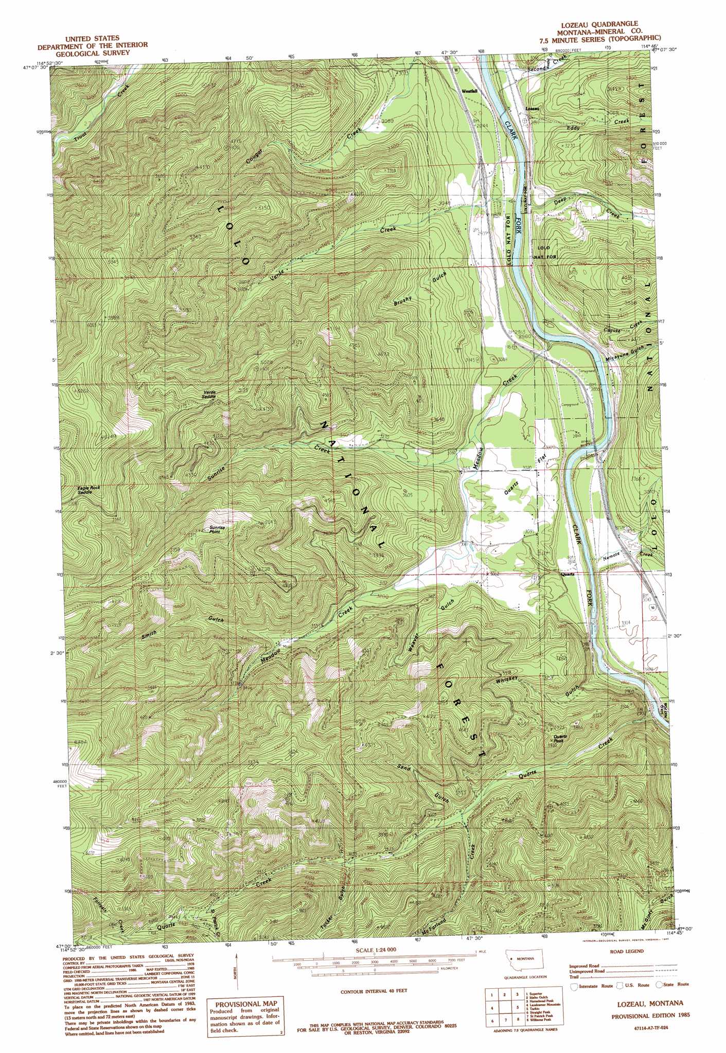
USGS Topo Quad 47114a7 - 1:24,000 scale
| Topo Map Name: | Lozeau |
| USGS Topo Quad ID: | 47114a7 |
| Print Size: | ca. 21 1/4" wide x 27" high |
| Southeast Coordinates: | 47° N latitude / 114.75° W longitude |
| Map Center Coordinates: | 47.0625° N latitude / 114.8125° W longitude |
| U.S. State: | MT |
| Filename: | o47114a7.jpg |
| Download Map JPG Image: | Lozeau topo map 1:24,000 scale |
| Map Type: | Topographic |
| Topo Series: | 7.5´ |
| Map Scale: | 1:24,000 |
| Source of Map Images: | United States Geological Survey (USGS) |
| Alternate Map Versions: |
Lozeau MT 1985, updated 1985 Download PDF Buy paper map Lozeau MT 1999, updated 2003 Download PDF Buy paper map Lozeau MT 2011 Download PDF Buy paper map Lozeau MT 2014 Download PDF Buy paper map |
| FStopo: | US Forest Service topo Lozeau is available: Download FStopo PDF Download FStopo TIF |
1:24,000 Topo Quads surrounding Lozeau
Saint Regis |
Keystone Peak |
Quinns Hot Springs |
Knowles |
Perma |
Wilson Gulch |
Superior |
Idaho Gulch |
Horsehead Peak |
Stark North |
Illinois Peak |
Landowner Mountain |
Lozeau |
Tarkio |
Stark South |
Hoodoo Pass |
Straight Peak |
Saint Patrick Peak |
Williams Peak |
Deer Peak |
Osier Ridge |
Bruin Hill |
Schley Mountain |
White Mountain |
Lupine Creek |
> Back to 47114a1 at 1:100,000 scale
> Back to 47114a1 at 1:250,000 scale
> Back to U.S. Topo Maps home
Lozeau topo map: Gazetteer
Lozeau: Crossings
Interchange 55 elevation 880m 2887′Lozeau: Flats
Quartz Flat elevation 943m 3093′Lozeau: Gaps
Eagle Rock Saddle elevation 1739m 5705′Verde Saddle elevation 1535m 5036′
Lozeau: Mines
Joe Doris Mine elevation 1108m 3635′Lucky 7 Mine elevation 1176m 3858′
Quartz Creek Mine elevation 1412m 4632′
Triangle Mine elevation 1519m 4983′
Wingo Mine elevation 1431m 4694′
X-Ray Vision Mine elevation 888m 2913′
Lozeau: Parks
Iron Mountain Mine Historical Marker elevation 872m 2860′Lozeau: Populated Places
Crescent City (historical) elevation 1024m 3359′Lozeau elevation 857m 2811′
Quartz elevation 883m 2896′
Westfall elevation 859m 2818′
Lozeau: Post Offices
Lozeau Post Office (historical) elevation 859m 2818′Quartz Post Office (historical) elevation 883m 2896′
Lozeau: Streams
Cayuse Creek elevation 825m 2706′Deep Creek elevation 843m 2765′
Eddy Creek elevation 883m 2896′
Fortysix Creek elevation 1436m 4711′
McFarland Creek elevation 1031m 3382′
Meadow Creek elevation 828m 2716′
Nellie Creek elevation 932m 3057′
Nemote Creek elevation 840m 2755′
Quartz Creek elevation 849m 2785′
Saint Patrick Creek elevation 1278m 4192′
Second Creek elevation 828m 2716′
Sunrise Creek elevation 915m 3001′
Verde Creek elevation 833m 2732′
Westfall Creek elevation 886m 2906′
Lozeau: Summits
Magone Mountain elevation 1681m 5515′Quartz Peak elevation 1199m 3933′
Sunrise Point elevation 1638m 5374′
Lozeau: Valleys
Brushy Gulch elevation 902m 2959′Louisiana Gulch elevation 1430m 4691′
Micayune Gulch elevation 874m 2867′
Sand Gulch elevation 1036m 3398′
Smith Gulch elevation 1058m 3471′
Tucker Gulch elevation 1135m 3723′
Weaver Gulch elevation 956m 3136′
Whiskey Gulch elevation 882m 2893′
Lozeau digital topo map on disk
Buy this Lozeau topo map showing relief, roads, GPS coordinates and other geographical features, as a high-resolution digital map file on DVD: