Saint Patrick Peak Topo Map Montana
To zoom in, hover over the map of Saint Patrick Peak
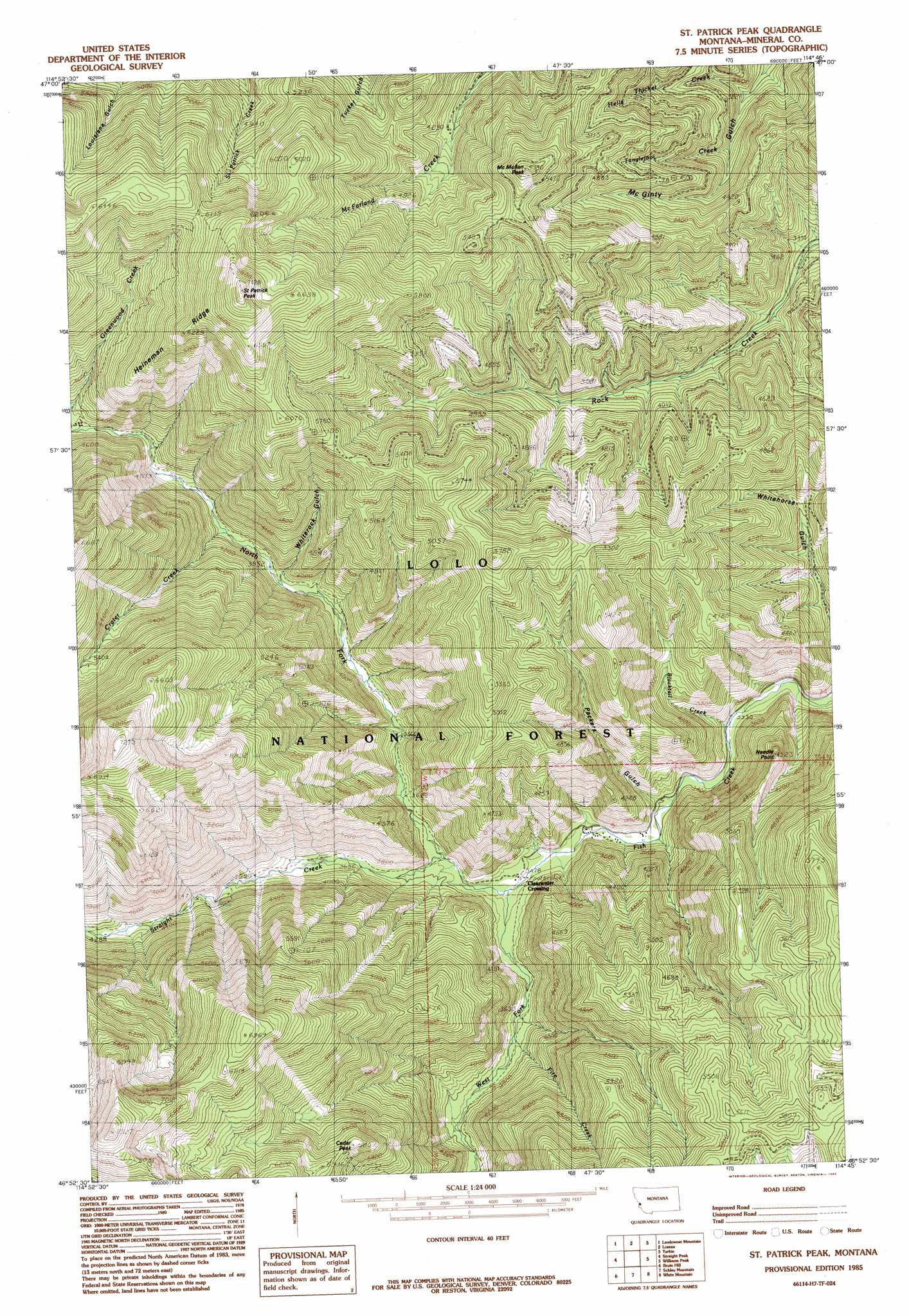
USGS Topo Quad 46114h7 - 1:24,000 scale
| Topo Map Name: | Saint Patrick Peak |
| USGS Topo Quad ID: | 46114h7 |
| Print Size: | ca. 21 1/4" wide x 27" high |
| Southeast Coordinates: | 46.875° N latitude / 114.75° W longitude |
| Map Center Coordinates: | 46.9375° N latitude / 114.8125° W longitude |
| U.S. State: | MT |
| Filename: | o46114h7.jpg |
| Download Map JPG Image: | Saint Patrick Peak topo map 1:24,000 scale |
| Map Type: | Topographic |
| Topo Series: | 7.5´ |
| Map Scale: | 1:24,000 |
| Source of Map Images: | United States Geological Survey (USGS) |
| Alternate Map Versions: |
St Patrick Peak MT 1985, updated 1985 Download PDF Buy paper map Saint Patrick Peak MT 1999, updated 2003 Download PDF Buy paper map Saint Patrick Peak MT 2011 Download PDF Buy paper map Saint Patrick Peak MT 2014 Download PDF Buy paper map |
| FStopo: | US Forest Service topo Saint Patrick Peak is available: Download FStopo PDF Download FStopo TIF |
1:24,000 Topo Quads surrounding Saint Patrick Peak
Wilson Gulch |
Superior |
Idaho Gulch |
Horsehead Peak |
Stark North |
Illinois Peak |
Landowner Mountain |
Lozeau |
Tarkio |
Stark South |
Hoodoo Pass |
Straight Peak |
Saint Patrick Peak |
Williams Peak |
Deer Peak |
Osier Ridge |
Bruin Hill |
Schley Mountain |
White Mountain |
Lupine Creek |
Gorman Hill |
Toboggan Ridge |
Rhodes Peak |
Granite Pass |
Lolo Hot Springs |
> Back to 46114e1 at 1:100,000 scale
> Back to 46114a1 at 1:250,000 scale
> Back to U.S. Topo Maps home
Saint Patrick Peak topo map: Gazetteer
Saint Patrick Peak: Ridges
Heineman Ridge elevation 1676m 5498′Saint Patrick Peak: Streams
Blacktail Creek elevation 1020m 3346′Crater Creek elevation 1227m 4025′
Fire Creek elevation 1130m 3707′
Hells Thicket Creek elevation 1043m 3421′
North Fork Fish Creek elevation 1064m 3490′
Straight Creek elevation 1082m 3549′
Tanglefoot Creek elevation 1114m 3654′
West Fork Fish Creek elevation 998m 3274′
Saint Patrick Peak: Summits
Cedar Peak elevation 1771m 5810′McMullan Peak elevation 1746m 5728′
Needle Point elevation 1375m 4511′
Rivulet Peak elevation 1441m 4727′
Saint Patrick Peak elevation 2132m 6994′
Saint Patrick Peak: Valleys
Packers Gulch elevation 1042m 3418′Whiterock Gulch elevation 1171m 3841′
Saint Patrick Peak digital topo map on disk
Buy this Saint Patrick Peak topo map showing relief, roads, GPS coordinates and other geographical features, as a high-resolution digital map file on DVD: