Bend Topo Map Montana
To zoom in, hover over the map of Bend
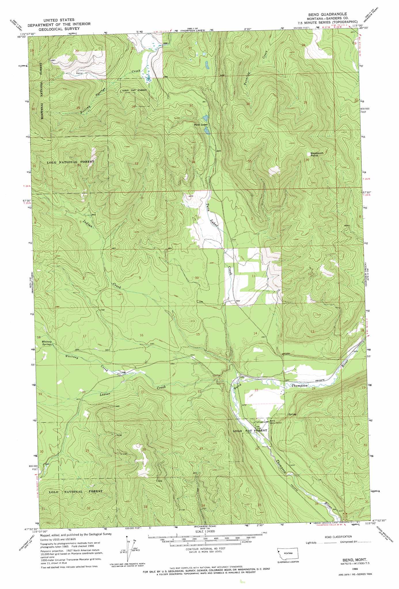
USGS Topo Quad 47115h1 - 1:24,000 scale
| Topo Map Name: | Bend |
| USGS Topo Quad ID: | 47115h1 |
| Print Size: | ca. 21 1/4" wide x 27" high |
| Southeast Coordinates: | 47.875° N latitude / 115° W longitude |
| Map Center Coordinates: | 47.9375° N latitude / 115.0625° W longitude |
| U.S. State: | MT |
| Filename: | o47115h1.jpg |
| Download Map JPG Image: | Bend topo map 1:24,000 scale |
| Map Type: | Topographic |
| Topo Series: | 7.5´ |
| Map Scale: | 1:24,000 |
| Source of Map Images: | United States Geological Survey (USGS) |
| Alternate Map Versions: |
Bend MT 1966, updated 1970 Download PDF Buy paper map Bend MT 1999, updated 2003 Download PDF Buy paper map Bend MT 2011 Download PDF Buy paper map Bend MT 2014 Download PDF Buy paper map |
| FStopo: | US Forest Service topo Bend is available: Download FStopo PDF Download FStopo TIF |
1:24,000 Topo Quads surrounding Bend
Fisher Mountain |
Calx Mountain |
Deer Creek |
Lynch Lake |
Dahl Lake |
Kenelty Mountain |
Loon Lake |
Thompson Lakes |
Meadow Peak |
Mcgregor Peak |
Miller Lake |
Mantrap Fork |
Bend |
Shroder Creek |
Murr Peak |
Vermilion Peak |
Fishtrap Lake |
Richards Peak |
Cook Mountain |
Bassoo Peak |
Mount Headley |
Priscilla Peak |
Calico Creek |
Loneman Creek |
Coney Peak |
> Back to 47115e1 at 1:100,000 scale
> Back to 47114a1 at 1:250,000 scale
> Back to U.S. Topo Maps home
Bend topo map: Gazetteer
Bend: Lakes
Twin Lakes elevation 1182m 3877′Bend: Populated Places
Bend elevation 991m 3251′Bend: Springs
Whitney Springs elevation 1123m 3684′Bend: Streams
Indian Creek elevation 987m 3238′Lazier Creek elevation 984m 3228′
Twin Lakes Creek elevation 1009m 3310′
Whitney Creek elevation 1091m 3579′
Bend: Summits
Skookum Point elevation 1573m 5160′Bend digital topo map on disk
Buy this Bend topo map showing relief, roads, GPS coordinates and other geographical features, as a high-resolution digital map file on DVD: