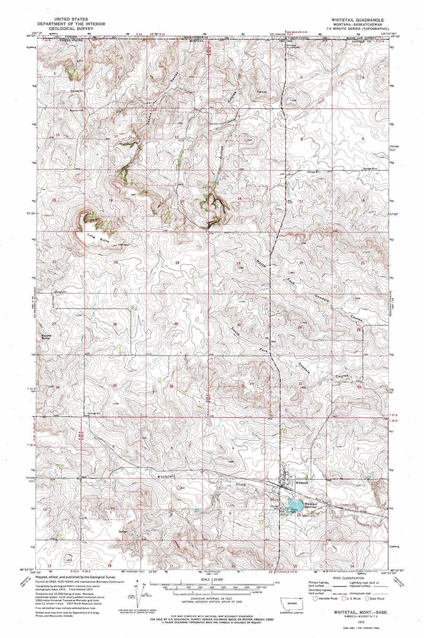
Whitetail Topo Map Montana
To zoom in, hover over the map of Whitetail
USGS Topo Quad 48105h2 - 1:24,000 scale
| Topo Map Name: | Whitetail |
| USGS Topo Quad ID: | 48105h2 |
| Print Size: | ca. 21 1/4" wide x 27" high |
| Southeast Coordinates: | 48.875° N latitude / 105.125° W longitude |
| Map Center Coordinates: | 48.9375° N latitude / 105.1875° W longitude |
| U.S. State: | MT |
| Filename: | o48105h2.jpg |
| Download Map JPG Image: | Whitetail topo map 1:24,000 scale |
| Map Type: | Topographic |
| Topo Series: | 7.5´ |
| Map Scale: | 1:24,000 |
| Source of Map Images: | United States Geological Survey (USGS) |
| Alternate Map Versions: |
Whitetail MT 1973, updated 1976 Download PDF Buy paper map Whitetail MT 2011 Download PDF Buy paper map Whitetail MT 2014 Download PDF Buy paper map |
1:24,000 Topo Quads surrounding Whitetail
Scobey Nw |
Si Merrell Slough |
Whitetail |
Goodale Coulee |
Daleview |
Scobey |
Madoc |
Flaxville |
Navajo |
Redstone |
Cabarett Coulee |
Line Coulee |
Pleasant Prairie Nw |
Pleasant Prairie Ne |
Soo Nw |
> Back to 48105e1 at 1:100,000 scale
> Back to 48104a1 at 1:250,000 scale
> Back to U.S. Topo Maps home
Whitetail topo map: Gazetteer
Whitetail: Dams
Hediger Dam elevation 825m 2706′Whitetail Dam elevation 761m 2496′
Whitetail: Populated Places
Whitetail elevation 763m 2503′Whitetail: Post Offices
Whitetail Post Office elevation 763m 2503′Whitetail: Reservoirs
Whitetail Reservoir elevation 754m 2473′Whitetail Storage Reservoir elevation 761m 2496′
Whitetail: Summits
Long Butte elevation 883m 2896′Whitetail: Valleys
Outlaw Coulee elevation 746m 2447′Whitetail: Wells
36N49E01DCAC01 Well elevation 826m 2709′36N49E01DCAC02 Well elevation 826m 2709′
36N49E12DCDC01 Well elevation 845m 2772′
36N49E12DCDD01 Well elevation 845m 2772′
36N50E03CBDD01 Well elevation 767m 2516′
36N50E03CDDC01 Well elevation 761m 2496′
36N50E03DDCC01 Well elevation 760m 2493′
36N50E10BACA01 Well elevation 763m 2503′
36N50E15BBAD01 Well elevation 786m 2578′
37N49E01CADB01 Well elevation 755m 2477′
37N49E01CCCC01 Well elevation 765m 2509′
37N49E01CCCC02 Well elevation 765m 2509′
37N49E03AADC01 Well elevation 773m 2536′
37N49E11DCDA01 Well elevation 805m 2641′
37N49E12AABB01 Well elevation 772m 2532′
37N49E12ABAA01 Well elevation 778m 2552′
37N49E13DBCB01 Well elevation 816m 2677′
37N50E05BBAA01 Well elevation 741m 2431′
37N50E17BABA01 Well elevation 776m 2545′
37N50E18ADAA01 Well elevation 787m 2582′
37N50E19DDDB01 Well elevation 813m 2667′
Whitetail digital topo map on disk
Buy this Whitetail topo map showing relief, roads, GPS coordinates and other geographical features, as a high-resolution digital map file on DVD:
Eastern Montana & Western North Dakota
Buy digital topo maps: Eastern Montana & Western North Dakota