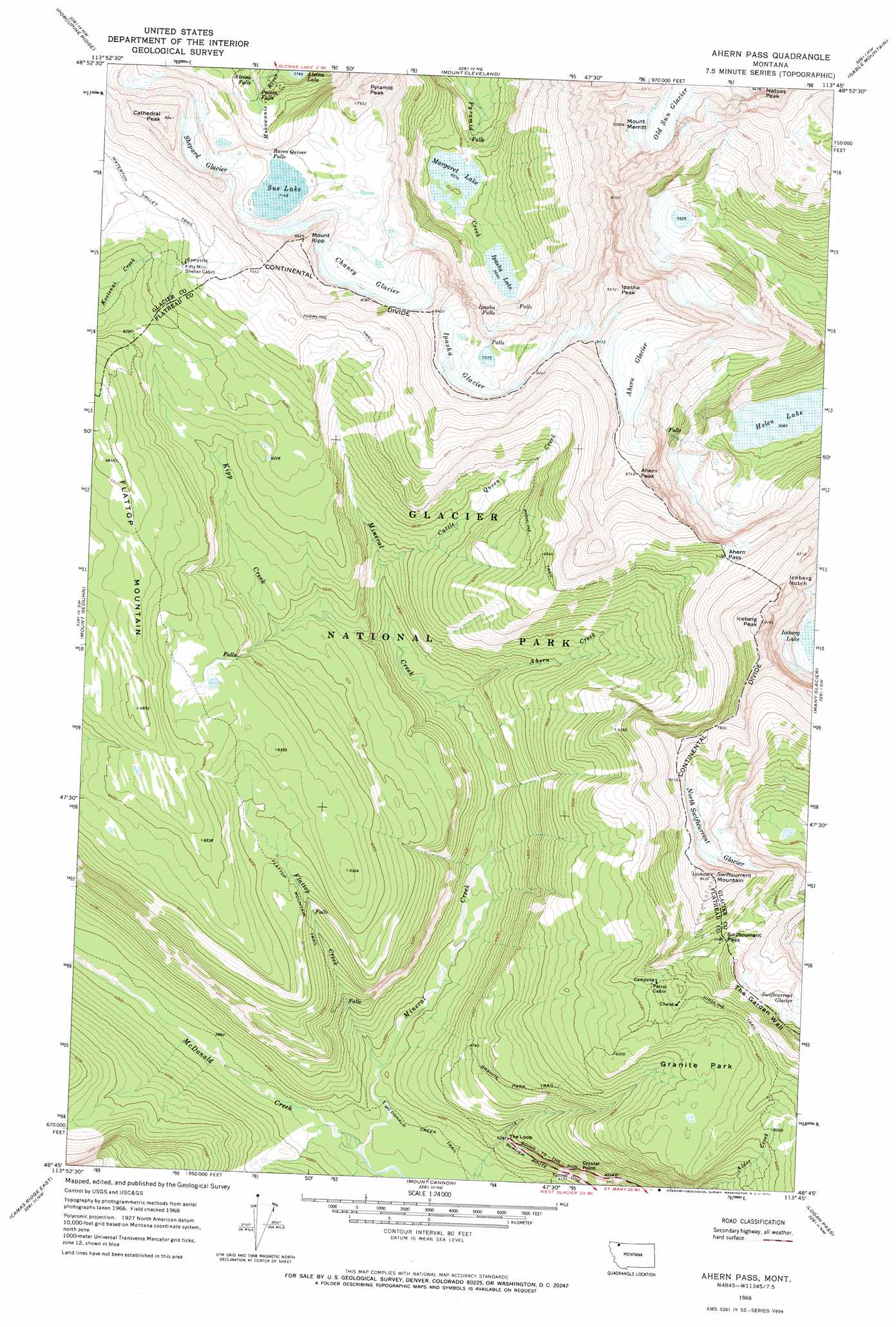
Ahern Pass Topo Map Montana
To zoom in, hover over the map of Ahern Pass
USGS Topo Quad 48113g7 - 1:24,000 scale
| Topo Map Name: | Ahern Pass |
| USGS Topo Quad ID: | 48113g7 |
| Print Size: | ca. 21 1/4" wide x 27" high |
| Southeast Coordinates: | 48.75° N latitude / 113.75° W longitude |
| Map Center Coordinates: | 48.8125° N latitude / 113.8125° W longitude |
| U.S. State: | MT |
| Filename: | o48113g7.jpg |
| Download Map JPG Image: | Ahern Pass topo map 1:24,000 scale |
| Map Type: | Topographic |
| Topo Series: | 7.5´ |
| Map Scale: | 1:24,000 |
| Source of Map Images: | United States Geological Survey (USGS) |
| Alternate Map Versions: |
Ahern Pass MT 1968, updated 1971 Download PDF Buy paper map Ahern Pass MT 1968, updated 1972 Download PDF Buy paper map Ahern Pass MT 1968, updated 1972 Download PDF Buy paper map Ahern Pass MT 2011 Download PDF Buy paper map Ahern Pass MT 2014 Download PDF Buy paper map |
1:24,000 Topo Quads surrounding Ahern Pass
Mount Carter |
Porcupine Ridge |
Mount Cleveland |
Gable Mountain |
Chief Mountain |
Vulture Peak |
Mount Geduhn |
Ahern Pass |
Many Glacier |
Lake Sherburne |
Camas Ridge West |
Camas Ridge East |
Mount Cannon |
Logan Pass |
Rising Sun |
Mcgee Meadow |
Lake Mcdonald West |
Lake Mcdonald East |
Mount Jackson |
Mount Stimson |
> Back to 48113e1 at 1:100,000 scale
> Back to 48112a1 at 1:250,000 scale
> Back to U.S. Topo Maps home
Ahern Pass topo map: Gazetteer
Ahern Pass: Falls
Atsina Falls elevation 1904m 6246′Ipasha Falls elevation 1915m 6282′
Paiota Falls elevation 1902m 6240′
Raven Quiver Falls elevation 2157m 7076′
Ahern Pass: Flats
Granite Park elevation 1850m 6069′Ahern Pass: Gaps
Ahern Pass elevation 2169m 7116′Iceberg Notch elevation 2535m 8316′
Swiftcurrent Pass elevation 2191m 7188′
Ahern Pass: Glaciers
Ahern Glacier elevation 2490m 8169′Chaney Glacier elevation 2258m 7408′
Ipasha Glacier elevation 2358m 7736′
North Swiftcurrent Glacier elevation 2185m 7168′
Old Sun Glacier elevation 2611m 8566′
Shepard Glacier elevation 2315m 7595′
Ahern Pass: Lakes
Atsina Lake elevation 1765m 5790′Helen Lake elevation 1551m 5088′
Ipasha Lake elevation 1727m 5666′
Margaret Lake elevation 1700m 5577′
Sue Lake elevation 2179m 7148′
Ahern Pass: Populated Places
Crystal Point elevation 1361m 4465′Ahern Pass: Streams
Ahern Creek elevation 1342m 4402′Cattle Queen Creek elevation 1482m 4862′
Flattop Creek elevation 1176m 3858′
Kipp Creek elevation 1402m 4599′
Mineral Creek elevation 1145m 3756′
Ahern Pass: Summits
Ahern Peak elevation 2668m 8753′Cathedral Peak elevation 2740m 8989′
Flattop Mountain elevation 2086m 6843′
Iceberg Peak elevation 2789m 9150′
Ipasha Peak elevation 2913m 9557′
Mount Kipp elevation 2686m 8812′
Mount Merritt elevation 3054m 10019′
Natoas Peak elevation 2820m 9251′
Pyramid Peak elevation 2487m 8159′
Swiftcurrent Mountain elevation 2551m 8369′
Ahern Pass: Trails
Flattop Mountain Trail elevation 1675m 5495′Granite Park Trail elevation 1547m 5075′
Highline Trail elevation 2003m 6571′
McDonald Creek Trail elevation 1167m 3828′
Ahern Pass digital topo map on disk
Buy this Ahern Pass topo map showing relief, roads, GPS coordinates and other geographical features, as a high-resolution digital map file on DVD: