Martin Peak Topo Map Washington
To zoom in, hover over the map of Martin Peak
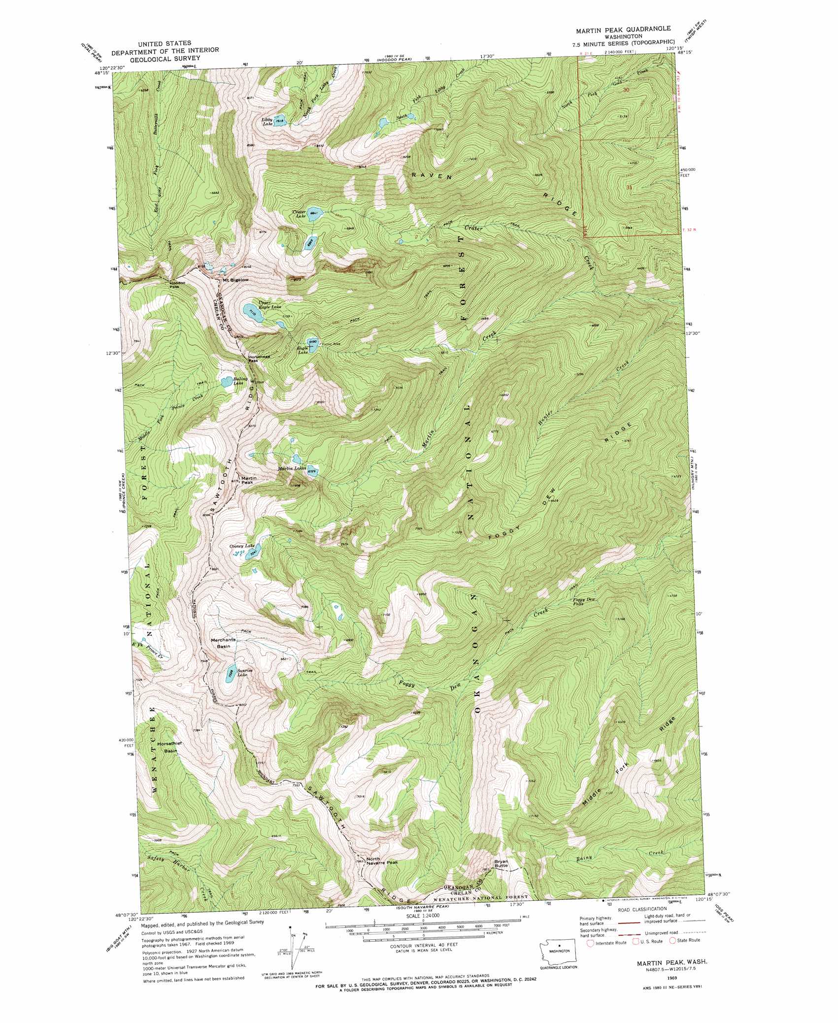
USGS Topo Quad 48120b3 - 1:24,000 scale
| Topo Map Name: | Martin Peak |
| USGS Topo Quad ID: | 48120b3 |
| Print Size: | ca. 21 1/4" wide x 27" high |
| Southeast Coordinates: | 48.125° N latitude / 120.25° W longitude |
| Map Center Coordinates: | 48.1875° N latitude / 120.3125° W longitude |
| U.S. State: | WA |
| Filename: | o48120b3.jpg |
| Download Map JPG Image: | Martin Peak topo map 1:24,000 scale |
| Map Type: | Topographic |
| Topo Series: | 7.5´ |
| Map Scale: | 1:24,000 |
| Source of Map Images: | United States Geological Survey (USGS) |
| Alternate Map Versions: |
Martin Peak WA 1969, updated 1972 Download PDF Buy paper map Martin Peak WA 1969, updated 1980 Download PDF Buy paper map Martin Peak WA 2002, updated 2006 Download PDF Buy paper map Martin Peak WA 2002, updated 2006 Download PDF Buy paper map Martin Peak WA 2011 Download PDF Buy paper map Martin Peak WA 2014 Download PDF Buy paper map |
| FStopo: | US Forest Service topo Martin Peak is available: Download FStopo PDF Download FStopo TIF |
1:24,000 Topo Quads surrounding Martin Peak
Gilbert |
Midnight Mountain |
Thompson Ridge |
Winthrop |
Blue Buck Mountain |
Sun Mountain |
Oval Peak |
Hoodoo Peak |
Twisp West |
Twisp East |
Lucerne |
Prince Creek |
Martin Peak |
Hungry Mountain |
Methow |
Pyramid Mountain |
Big Goat Mountain |
South Navarre Peak |
Oss Peak |
Cooper Mountain |
Silver Falls |
Brief |
Stormy Mountain |
Manson |
Cooper Ridge |
> Back to 48120a1 at 1:100,000 scale
> Back to 48120a1 at 1:250,000 scale
> Back to U.S. Topo Maps home
Martin Peak topo map: Gazetteer
Martin Peak: Basins
Horsethief Basin elevation 1977m 6486′Merchants Basin elevation 2094m 6870′
Martin Peak: Dams
Libby Lake Dam elevation 2325m 7627′Martin Peak: Falls
Foggy Dew Falls elevation 1307m 4288′Martin Peak: Gaps
Hoodoo Pass elevation 2271m 7450′Horsehead Pass elevation 2298m 7539′
Martin Peak: Lakes
Boiling Lake elevation 2119m 6952′Cooney Lake elevation 2209m 7247′
Crater Lake elevation 2093m 6866′
Eagle Lake elevation 1981m 6499′
Martin Lakes elevation 2072m 6797′
Sunrise Lake elevation 2205m 7234′
Upper Eagle Lake elevation 2169m 7116′
Martin Peak: Reservoirs
Libby Lake elevation 2325m 7627′Martin Peak: Ridges
Foggy Dew Ridge elevation 1956m 6417′Raven Ridge elevation 1973m 6473′
Sawtooth Ridge elevation 2508m 8228′
Martin Peak: Streams
Hunter Creek elevation 998m 3274′Martin Creek elevation 1157m 3795′
Martin Peak: Summits
Bryan Butte elevation 2385m 7824′Martin Peak elevation 2545m 8349′
Mount Bigelow elevation 2574m 8444′
North Navarre Peak elevation 2433m 7982′
Martin Peak digital topo map on disk
Buy this Martin Peak topo map showing relief, roads, GPS coordinates and other geographical features, as a high-resolution digital map file on DVD: