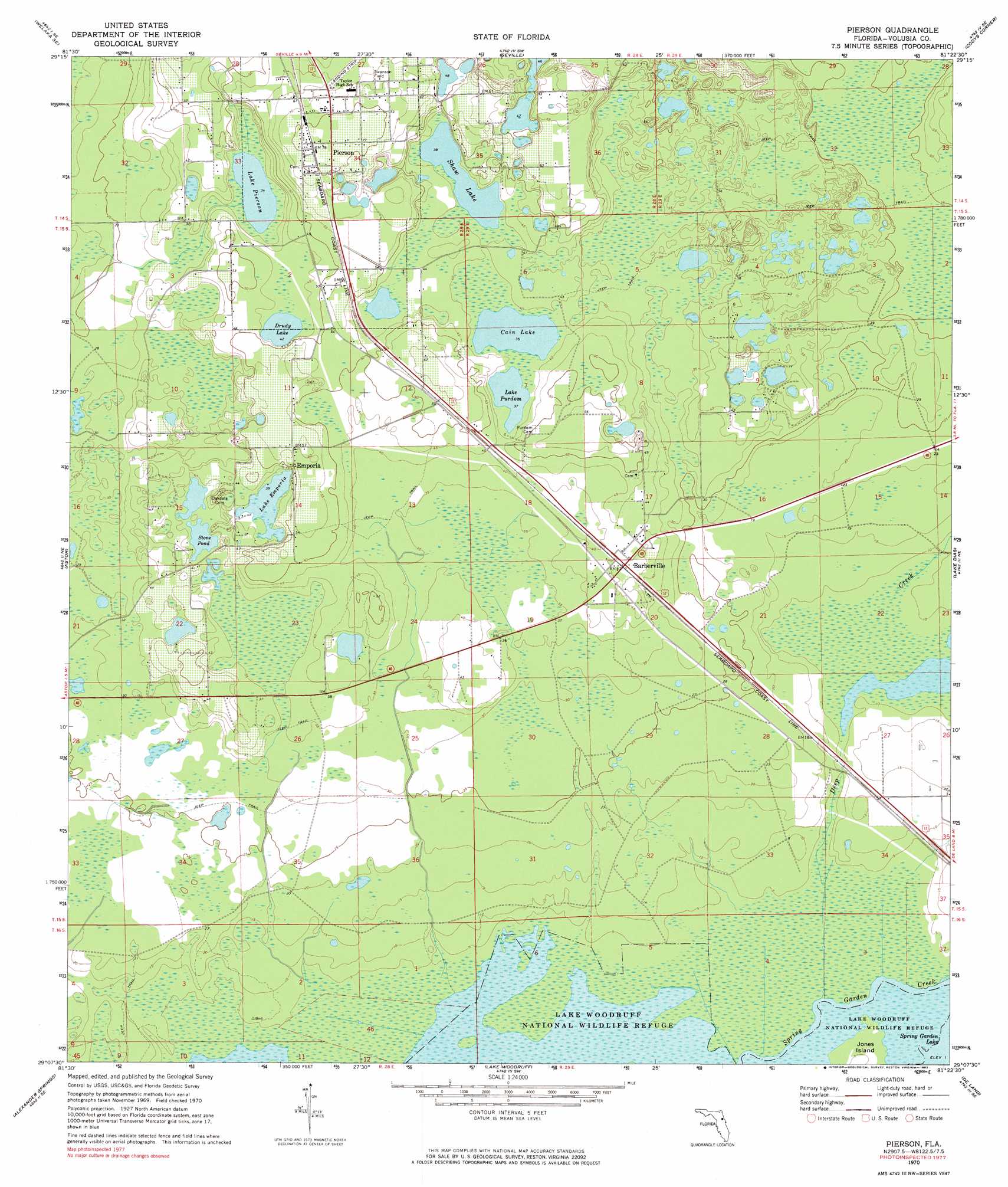
Pierson Topo Map Florida
To zoom in, hover over the map of Pierson
USGS Topo Quad 29081b4 - 1:24,000 scale
| Topo Map Name: | Pierson |
| USGS Topo Quad ID: | 29081b4 |
| Print Size: | ca. 21 1/4" wide x 27" high |
| Southeast Coordinates: | 29.125° N latitude / 81.375° W longitude |
| Map Center Coordinates: | 29.1875° N latitude / 81.4375° W longitude |
| U.S. State: | FL |
| Filename: | O29081B4.jpg |
| Download Map JPG Image: | Pierson topo map 1:24,000 scale |
| Map Type: | Topographic |
| Topo Series: | 7.5´ |
| Map Scale: | 1:24,000 |
| Source of Map Images: | United States Geological Survey (USGS) |
| Alternate Map Versions: |
Pierson FL 1970, updated 1973 Download PDF Buy paper map Pierson FL 1970, updated 1983 Download PDF Buy paper map Pierson FL 2012 Download PDF Buy paper map Pierson FL 2015 Download PDF Buy paper map |
1:24,000 Topo Quads surrounding Pierson
Welaka |
Crescent City |
Saint Johns Park |
Bunnell |
Flagler Beach West |
Salt Springs |
Welaka Se |
Seville |
Codys Corner |
Favoretta |
Juniper Springs |
Astor |
Pierson |
Lake Dias |
Daytona Beach Nw |
Farles Lake |
Alexander Springs |
Lake Woodruff |
De Land |
Daytona Beach Sw |
Umatilla |
Paisley |
Pine Lakes |
Orange City |
Lake Helen |
> Back to 29081a1 at 1:100,000 scale
> Back to 29080a1 at 1:250,000 scale
> Back to U.S. Topo Maps home
Pierson topo map: Gazetteer
Pierson: Airports
Pierson Municipal Airport elevation 18m 59′Pierson: Lakes
Cain Lake elevation 11m 36′Drudy Lake elevation 12m 39′
Lake Emporia elevation 12m 39′
Lake Pierson elevation 10m 32′
Lake Purdom elevation 11m 36′
Shaw Lake elevation 11m 36′
Stone Pond elevation 11m 36′
Pierson: Parks
Lake Woodruff National Wildlife Refuge elevation 0m 0′Pierson Town Park Sports Complex elevation 20m 65′
Swanson Field elevation 20m 65′
Pierson: Populated Places
Barberville elevation 14m 45′Conrad elevation 4m 13′
Eldridge elevation 15m 49′
Emporia elevation 14m 45′
Pierson elevation 23m 75′
Pierson: Post Offices
Barbersville Post Office elevation 13m 42′Pierson Post Office elevation 23m 75′
Pierson: Streams
Deep Creek elevation 0m 0′Pierson digital topo map on disk
Buy this Pierson topo map showing relief, roads, GPS coordinates and other geographical features, as a high-resolution digital map file on DVD: