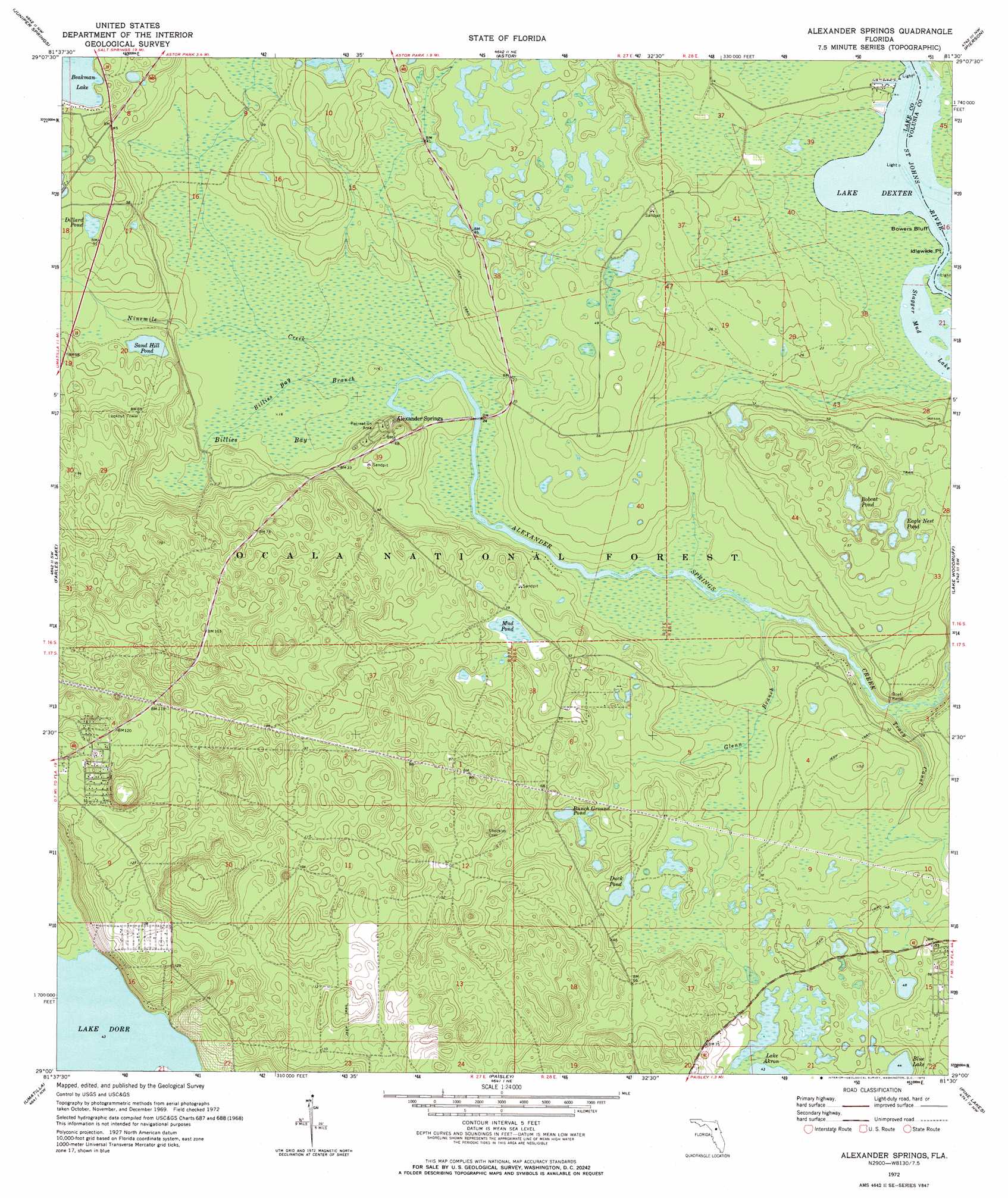
Alexander Springs Topo Map Florida
To zoom in, hover over the map of Alexander Springs
USGS Topo Quad 29081a5 - 1:24,000 scale
| Topo Map Name: | Alexander Springs |
| USGS Topo Quad ID: | 29081a5 |
| Print Size: | ca. 21 1/4" wide x 27" high |
| Southeast Coordinates: | 29° N latitude / 81.5° W longitude |
| Map Center Coordinates: | 29.0625° N latitude / 81.5625° W longitude |
| U.S. State: | FL |
| Filename: | O29081A5.jpg |
| Download Map JPG Image: | Alexander Springs topo map 1:24,000 scale |
| Map Type: | Topographic |
| Topo Series: | 7.5´ |
| Map Scale: | 1:24,000 |
| Source of Map Images: | United States Geological Survey (USGS) |
| Alternate Map Versions: |
Alexander Springs FL 1972, updated 1973 Download PDF Buy paper map Alexander Springs FL 1994, updated 1998 Download PDF Buy paper map Alexander Springs FL 2012 Download PDF Buy paper map Alexander Springs FL 2015 Download PDF Buy paper map |
| FStopo: | US Forest Service topo Alexander Springs is available: Download FStopo PDF Download FStopo TIF |
1:24,000 Topo Quads surrounding Alexander Springs
Lake Kerr |
Salt Springs |
Welaka Se |
Seville |
Codys Corner |
Halfmoon Lake |
Juniper Springs |
Astor |
Pierson |
Lake Dias |
Lake Mary |
Farles Lake |
Alexander Springs |
Lake Woodruff |
De Land |
Emeralda Island |
Umatilla |
Paisley |
Pine Lakes |
Orange City |
Leesburg East |
Eustis |
Sorrento |
Sanford Sw |
Sanford |
> Back to 29081a1 at 1:100,000 scale
> Back to 29080a1 at 1:250,000 scale
> Back to U.S. Topo Maps home
Alexander Springs topo map: Gazetteer
Alexander Springs: Bays
Billies Bay elevation 5m 16′Alexander Springs: Canals
Tracy Canal elevation 10m 32′Alexander Springs: Capes
Idlewilde Point elevation 0m 0′Alexander Springs: Cliffs
Bowers Bluff elevation 0m 0′Alexander Springs: Lakes
Blue Lake elevation 13m 42′Bobcat Pond elevation 11m 36′
Bunch Ground Pond elevation 11m 36′
Dillard Pond elevation 14m 45′
Duck Pond elevation 12m 39′
Eagle Nest Pond elevation 9m 29′
Lake Dorr elevation 13m 42′
Mud Pond elevation 11m 36′
Sand Hill Pond elevation 9m 29′
Scrub Jay Pond elevation 14m 45′
Stagger Mud Lake elevation 0m 0′
Alexander Springs: Parks
Alexander Springs Recreation Area elevation 12m 39′Lakeview Park elevation 14m 45′
Alexander Springs: Populated Places
Alexander Springs elevation 11m 36′Powells Campground Mobile Home Park elevation 0m 0′
Alexander Springs: Streams
Billies Branch elevation 4m 13′Glenn Branch elevation 1m 3′
Ninemile Creek elevation 4m 13′
Alexander Springs: Trails
Flatwoods Trail elevation 32m 104′Alexander Springs digital topo map on disk
Buy this Alexander Springs topo map showing relief, roads, GPS coordinates and other geographical features, as a high-resolution digital map file on DVD: