Newberry Sw Topo Map Florida
To zoom in, hover over the map of Newberry Sw
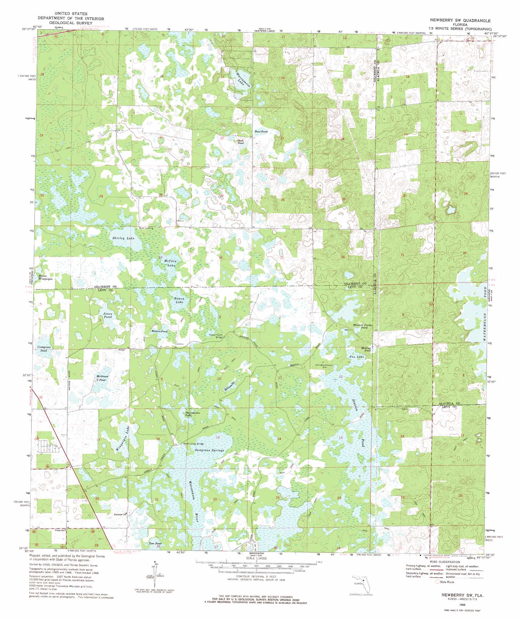
USGS Topo Quad 29082e6 - 1:24,000 scale
| Topo Map Name: | Newberry Sw |
| USGS Topo Quad ID: | 29082e6 |
| Print Size: | ca. 21 1/4" wide x 27" high |
| Southeast Coordinates: | 29.5° N latitude / 82.625° W longitude |
| Map Center Coordinates: | 29.5625° N latitude / 82.6875° W longitude |
| U.S. State: | FL |
| Filename: | O29082E6.jpg |
| Download Map JPG Image: | Newberry Sw topo map 1:24,000 scale |
| Map Type: | Topographic |
| Topo Series: | 7.5´ |
| Map Scale: | 1:24,000 |
| Source of Map Images: | United States Geological Survey (USGS) |
| Alternate Map Versions: |
Newberry SW FL 1968, updated 1969 Download PDF Buy paper map Newberry SW FL 1968, updated 1977 Download PDF Buy paper map Newberry SW FL 2012 Download PDF Buy paper map Newberry SW FL 2015 Download PDF Buy paper map |
1:24,000 Topo Quads surrounding Newberry Sw
Hatchbend |
Bell |
High Springs Sw |
High Springs |
Alachua |
Wannee |
Fourmile Lake |
Waters Lake |
Newberry |
Gainesville West |
Suwannee River |
Trenton |
Newberry Sw |
Archer |
Arredondo |
Manatee Springs |
Chiefland |
Bronson |
Bronson Ne |
Williston |
Chiefland Sw |
Otter Creek |
Bronson Sw |
Bronson Se |
Morriston |
> Back to 29082e1 at 1:100,000 scale
> Back to 29082a1 at 1:250,000 scale
> Back to U.S. Topo Maps home
Newberry Sw topo map: Gazetteer
Newberry Sw: Bridges
Asbell Creek Bridge elevation 16m 52′Porter Smith Bridge elevation 17m 55′
Newberry Sw: Lakes
Billups Pond elevation 16m 52′Boat Pond elevation 28m 91′
Bowen Lake elevation 17m 55′
Crabgrass Pond elevation 16m 52′
Doorshutter Lake elevation 16m 52′
Duck Pond elevation 25m 82′
Jones Pond elevation 16m 52′
McCain Lake elevation 17m 55′
McGowen Pond elevation 16m 52′
Shirley Lake elevation 17m 55′
Station Pond elevation 16m 52′
Waccasassa Lake elevation 27m 88′
Waters Pond elevation 16m 52′
Newberry Sw: Reservoirs
Fox Lake elevation 16m 52′Meeting Pond elevation 17m 55′
Mineral Feeder Pond elevation 17m 55′
Winquipin Lake elevation 16m 52′
Newberry Sw: Swamps
Sawgrass Springs elevation 16m 52′Tom Pond elevation 16m 52′
Waccasassa River elevation 16m 52′
Newberry Sw digital topo map on disk
Buy this Newberry Sw topo map showing relief, roads, GPS coordinates and other geographical features, as a high-resolution digital map file on DVD: