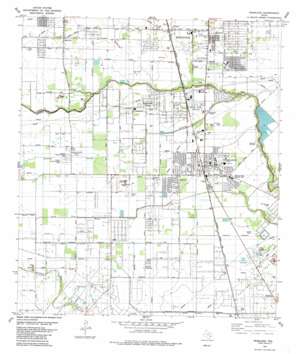
Pearland Topo Map Texas
To zoom in, hover over the map of Pearland
USGS Topo Quad 29095e3 - 1:24,000 scale
| Topo Map Name: | Pearland |
| USGS Topo Quad ID: | 29095e3 |
| Print Size: | ca. 21 1/4" wide x 27" high |
| Southeast Coordinates: | 29.5° N latitude / 95.25° W longitude |
| Map Center Coordinates: | 29.5625° N latitude / 95.3125° W longitude |
| U.S. State: | TX |
| Filename: | o29095e3.jpg |
| Download Map JPG Image: | Pearland topo map 1:24,000 scale |
| Map Type: | Topographic |
| Topo Series: | 7.5´ |
| Map Scale: | 1:24,000 |
| Source of Map Images: | United States Geological Survey (USGS) |
| Alternate Map Versions: |
Pearland TX 1955, updated 1957 Download PDF Buy paper map Pearland TX 1955, updated 1970 Download PDF Buy paper map Pearland TX 1982, updated 1983 Download PDF Buy paper map Pearland TX 1995, updated 1998 Download PDF Buy paper map Pearland TX 2010 Download PDF Buy paper map Pearland TX 2013 Download PDF Buy paper map Pearland TX 2016 Download PDF Buy paper map |
1:24,000 Topo Quads surrounding Pearland
> Back to 29095e1 at 1:100,000 scale
> Back to 29094a1 at 1:250,000 scale
> Back to U.S. Topo Maps home
Pearland topo map: Gazetteer
Pearland: Airports
A and A Flying Service Airport elevation 14m 45′Bradair Heliport elevation 15m 49′
Gulfcoast Heliport elevation 16m 52′
Houston Airpark elevation 14m 45′
Joe Rye Heliport elevation 15m 49′
M D K Field Heliport elevation 15m 49′
Metro Heli-Pad elevation 16m 52′
Pearland Heliport elevation 14m 45′
Skyway Manor Airport elevation 16m 52′
Pearland: Dams
Nelson Levee elevation 10m 32′Pearland: Guts
Hickory Slough elevation 17m 55′Pearland: Oilfields
Manvel Oil Field elevation 18m 59′Mykawa Oil Field elevation 15m 49′
Pearland: Parks
Christia Adair County Park elevation 16m 52′Dads Club Community Park elevation 16m 52′
Independence Park elevation 14m 45′
Jones Park elevation 14m 45′
McLean Road Park elevation 14m 45′
Pearland Stadium elevation 14m 45′
Presner Stadium elevation 14m 45′
Pearland: Populated Places
Alexander Landing elevation 14m 45′Almeda Genoa elevation 15m 49′
Banbury Cross elevation 13m 42′
Brookside Village elevation 16m 52′
Cobblestone elevation 15m 49′
Country Place elevation 17m 55′
Fairway Village elevation 17m 55′
Garden Acres elevation 16m 52′
Hastings elevation 14m 45′
Heritage Green elevation 14m 45′
Hickory Creek Place elevation 15m 49′
Holloway Heights elevation 17m 55′
Lakepointe elevation 17m 55′
Lakes of Country Place elevation 16m 52′
Langston Place elevation 15m 49′
Linwood elevation 14m 45′
Magnolia Place elevation 14m 45′
Meadowview elevation 17m 55′
Minnetex elevation 16m 52′
Mykawa elevation 15m 49′
Oakbrook Estates elevation 14m 45′
Parkview elevation 15m 49′
Pearland elevation 15m 49′
Ravenwood Estates elevation 16m 52′
Regency Park elevation 14m 45′
Ryan Acres elevation 15m 49′
Sedgewood elevation 18m 59′
Shadycrest elevation 15m 49′
Shamrock Manor elevation 16m 52′
Sherwood elevation 14m 45′
Skyscraper Shadows elevation 14m 45′
Southdown elevation 17m 55′
Southwyck elevation 17m 55′
Turner elevation 12m 39′
Val Verde East elevation 15m 49′
West Lea elevation 16m 52′
West Oaks elevation 16m 52′
West Oaks Village elevation 16m 52′
Westchester Estates elevation 17m 55′
Westminster elevation 15m 49′
Westwood Village elevation 15m 49′
Pearland: Post Offices
Pearland Post Office elevation 15m 49′Pearland: Reservoirs
Nelson Reservoir elevation 10m 32′Pearland: Streams
North Fork Marys Creek elevation 15m 49′South Fork Marys Creek elevation 15m 49′
Pearland digital topo map on disk
Buy this Pearland topo map showing relief, roads, GPS coordinates and other geographical features, as a high-resolution digital map file on DVD:


