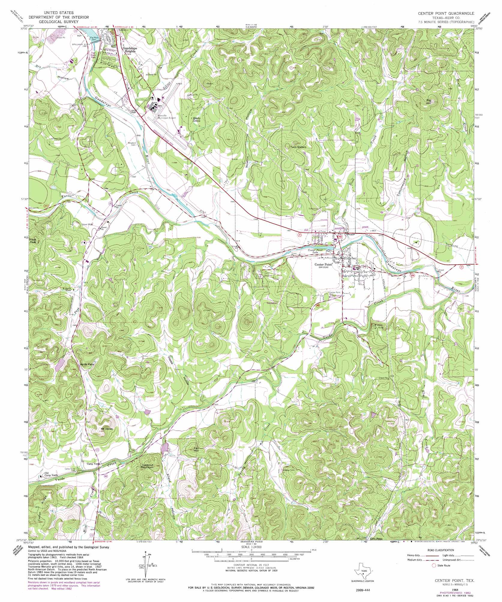
Center Point Topo Map Texas
To zoom in, hover over the map of Center Point
USGS Topo Quad 29099h1 - 1:24,000 scale
| Topo Map Name: | Center Point |
| USGS Topo Quad ID: | 29099h1 |
| Print Size: | ca. 21 1/4" wide x 27" high |
| Southeast Coordinates: | 29.875° N latitude / 99° W longitude |
| Map Center Coordinates: | 29.9375° N latitude / 99.0625° W longitude |
| U.S. State: | TX |
| Filename: | o29099h1.jpg |
| Download Map JPG Image: | Center Point topo map 1:24,000 scale |
| Map Type: | Topographic |
| Topo Series: | 7.5´ |
| Map Scale: | 1:24,000 |
| Source of Map Images: | United States Geological Survey (USGS) |
| Alternate Map Versions: |
Center Point TX 1964, updated 1966 Download PDF Buy paper map Center Point TX 1964, updated 1983 Download PDF Buy paper map Center Point TX 2010 Download PDF Buy paper map Center Point TX 2013 Download PDF Buy paper map Center Point TX 2016 Download PDF Buy paper map |
1:24,000 Topo Quads surrounding Center Point
Mountain Home |
Nott Branch |
Morris Ranch |
Oak Crest Park |
Cain City |
Hunt |
Kerrville |
Legion |
Cypress Creek |
Rafter Hollow |
Echo Hill Ranch |
Fall Creek |
Center Point |
Comfort |
Waring |
A Bar A Ranch |
Rock Cliff Reservoir |
Bandera Pass |
Turkey Knob |
Ranger Creek |
Tarpley |
Tarpley Pass |
Bandera |
Pipe Creek |
Jack Mountain |
> Back to 29099e1 at 1:100,000 scale
> Back to 29098a1 at 1:250,000 scale
> Back to U.S. Topo Maps home
Center Point topo map: Gazetteer
Center Point: Airports
Kerrville Municipal/Louis Schreiner Field elevation 485m 1591′Center Point: Dams
Center Point Lake Dam elevation 450m 1476′Flat Rock Dam elevation 477m 1564′
Kerrville Lake Dam elevation 479m 1571′
Tuck Lake Dam elevation 489m 1604′
Center Point: Gaps
Verde Pass elevation 545m 1788′Center Point: Parks
Flatrock Park elevation 475m 1558′Center Point: Populated Places
Camp Verde elevation 491m 1610′Center Point elevation 467m 1532′
Guadalupe Heights elevation 498m 1633′
Shady Grove elevation 504m 1653′
Center Point: Reservoirs
Center Point Lake elevation 450m 1476′Dam C Lake elevation 450m 1476′
Kerrville Lake elevation 479m 1571′
Tuck Lake elevation 489m 1604′
Center Point: Streams
Elm Creek elevation 445m 1459′Mico Creek elevation 487m 1597′
Pass Creek elevation 464m 1522′
Silver Creek elevation 469m 1538′
Spring Creek elevation 469m 1538′
Steel Creek elevation 450m 1476′
Turtle Creek elevation 463m 1519′
Verde Creek elevation 443m 1453′
Center Point: Summits
Big Hill elevation 580m 1902′Fall Hill elevation 530m 1738′
Lookout Mountain elevation 542m 1778′
Mount Verde elevation 574m 1883′
Pikes Peak elevation 557m 1827′
Twin Sisters elevation 533m 1748′
Center Point: Valleys
Cottonwood Hollow elevation 461m 1512′Dry Hollow elevation 469m 1538′
Happy Hollow elevation 476m 1561′
Klein Hollow elevation 482m 1581′
Nowlin Hollow elevation 463m 1519′
Center Point digital topo map on disk
Buy this Center Point topo map showing relief, roads, GPS coordinates and other geographical features, as a high-resolution digital map file on DVD: