Prairieville Topo Map Louisiana
To zoom in, hover over the map of Prairieville
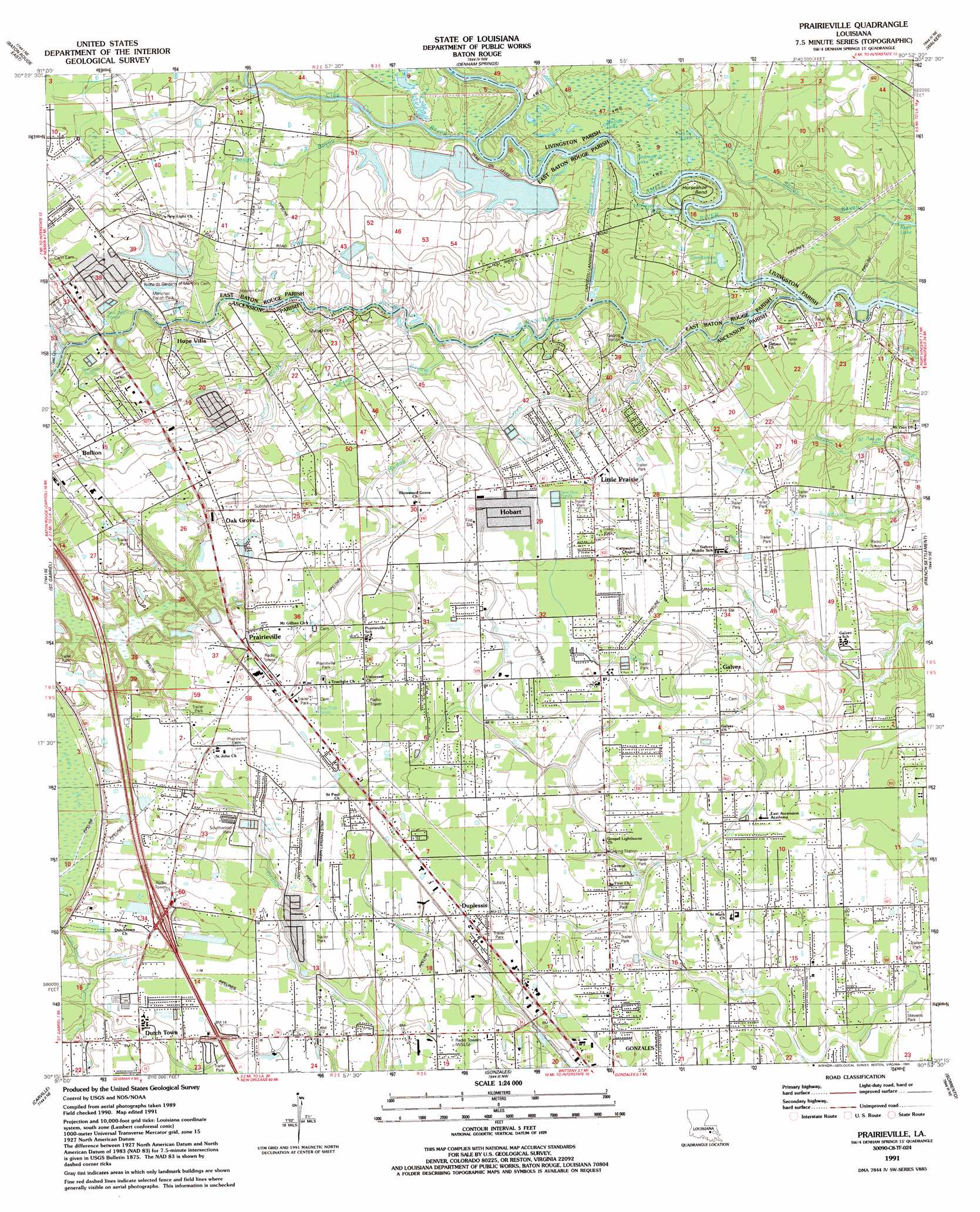
USGS Topo Quad 30090c8 - 1:24,000 scale
| Topo Map Name: | Prairieville |
| USGS Topo Quad ID: | 30090c8 |
| Print Size: | ca. 21 1/4" wide x 27" high |
| Southeast Coordinates: | 30.25° N latitude / 90.875° W longitude |
| Map Center Coordinates: | 30.3125° N latitude / 90.9375° W longitude |
| U.S. State: | LA |
| Filename: | o30090c8.jpg |
| Download Map JPG Image: | Prairieville topo map 1:24,000 scale |
| Map Type: | Topographic |
| Topo Series: | 7.5´ |
| Map Scale: | 1:24,000 |
| Source of Map Images: | United States Geological Survey (USGS) |
| Alternate Map Versions: |
Prairieville LA 1953, updated 1954 Download PDF Buy paper map Prairieville LA 1963, updated 1964 Download PDF Buy paper map Prairieville LA 1963, updated 1972 Download PDF Buy paper map Prairieville LA 1963, updated 1981 Download PDF Buy paper map Prairieville LA 1963, updated 1984 Download PDF Buy paper map Prairieville LA 1991, updated 1991 Download PDF Buy paper map Prairieville LA 1991, updated 1991 Download PDF Buy paper map Prairieville LA 1995, updated 1998 Download PDF Buy paper map Prairieville LA 2012 Download PDF Buy paper map Prairieville LA 2015 Download PDF Buy paper map |
1:24,000 Topo Quads surrounding Prairieville
Scotlandville |
Comite |
Watson |
Satsuma |
Holden |
Baton Rouge West |
Baton Rouge East |
Denham Springs |
Walker |
Frost |
Plaquemine |
Saint Gabriel |
Prairieville |
French Settlement |
Whitehall |
White Castle |
Carville |
Gonzales |
Sorrento |
Mount Airy Nw |
Lone Star |
Belle Rose |
Donaldsonville |
Convent |
Lutcher |
> Back to 30090a1 at 1:100,000 scale
> Back to 30090a1 at 1:250,000 scale
> Back to U.S. Topo Maps home
Prairieville topo map: Gazetteer
Prairieville: Airports
Capozzoli Landing Strip elevation 3m 9′Don Babin Airport elevation 5m 16′
Prairieville: Bends
Horseshoe Bend elevation 2m 6′Prairieville: Cliffs
Mallets Bluff elevation 6m 19′Prairieville: Crossings
Interchange 173 elevation 6m 19′Prairieville: Lakes
Ficklin Lake elevation 3m 9′Horseshoe Lake elevation 2m 6′
Melton Lake elevation 3m 9′
Redman Junior Lake elevation 1m 3′
Redman Lake elevation 1m 3′
Sportsman Lake elevation 1m 3′
Prairieville: Oilfields
Gonzales Oil Field elevation 4m 13′Little Prairie Gas Field elevation 7m 22′
Mallets Bluff Oil Field elevation 3m 9′
Prairieville: Parks
Airline Highway Parish Park elevation 5m 16′Manchac Parish Park elevation 4m 13′
Paula Park elevation 5m 16′
Prairieville Park elevation 6m 19′
Southwood Park elevation 4m 13′
Stevens Park elevation 2m 6′
Prairieville: Populated Places
Bullion elevation 9m 29′Duplessis elevation 5m 16′
Dutch Town elevation 4m 13′
Elliot Acres elevation 7m 22′
Galvez elevation 5m 16′
Galvez Town elevation 3m 9′
Hobart elevation 7m 22′
Hope Villa elevation 8m 26′
Hopeville (historical) elevation 4m 13′
Little Prairie elevation 6m 19′
Oak Grove elevation 7m 22′
Pecan Cove elevation 8m 26′
Pecan Creek elevation 8m 26′
Prairieville elevation 7m 22′
Prairieville: Post Offices
Duplessis Post Office elevation 6m 19′Prairieville Post Office elevation 7m 22′
Prairieville: Streams
Bayou Manchac elevation 0m 0′Boggy Cut Bayou elevation 5m 16′
Clay Cut Bayou elevation 4m 13′
Cotton Bayou elevation 1m 3′
Jim Bayou elevation 2m 6′
Johnson Bayou elevation 2m 6′
Muddy Creek elevation 0m 0′
Roddy Bayou elevation 4m 13′
Sides Bayou elevation 2m 6′
Welsh Gully elevation 1m 3′
Prairieville digital topo map on disk
Buy this Prairieville topo map showing relief, roads, GPS coordinates and other geographical features, as a high-resolution digital map file on DVD: