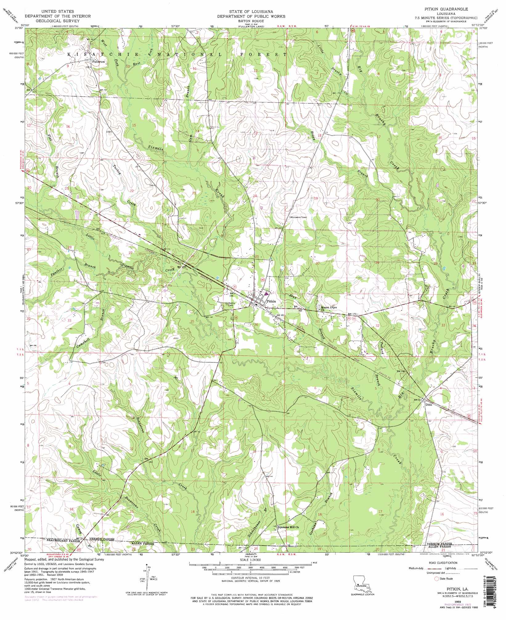
Pitkin Topo Map Louisiana
To zoom in, hover over the map of Pitkin
USGS Topo Quad 30092h8 - 1:24,000 scale
| Topo Map Name: | Pitkin |
| USGS Topo Quad ID: | 30092h8 |
| Print Size: | ca. 21 1/4" wide x 27" high |
| Southeast Coordinates: | 30.875° N latitude / 92.875° W longitude |
| Map Center Coordinates: | 30.9375° N latitude / 92.9375° W longitude |
| U.S. State: | LA |
| Filename: | o30092h8.jpg |
| Download Map JPG Image: | Pitkin topo map 1:24,000 scale |
| Map Type: | Topographic |
| Topo Series: | 7.5´ |
| Map Scale: | 1:24,000 |
| Source of Map Images: | United States Geological Survey (USGS) |
| Alternate Map Versions: |
Pitkin LA 1951, updated 1952 Download PDF Buy paper map Pitkin LA 1959, updated 1960 Download PDF Buy paper map Pitkin LA 1959, updated 1962 Download PDF Buy paper map Pitkin LA 1959, updated 1976 Download PDF Buy paper map Pitkin LA 1959, updated 1976 Download PDF Buy paper map Pitkin LA 2003, updated 2005 Download PDF Buy paper map Pitkin LA 2012 Download PDF Buy paper map Pitkin LA 2015 Download PDF Buy paper map |
| FStopo: | US Forest Service topo Pitkin is available: Download FStopo PDF Download FStopo TIF |
1:24,000 Topo Quads surrounding Pitkin
Slagle |
Simpson South |
Lacamp |
Sieper |
Elmer |
Fort Polk |
Birds Creek |
Fullerton Lake |
Afeman |
Melder |
Hurricane Branch |
Sugrue |
Pitkin |
Steep Gully |
Pawnee |
Boneset Creek |
Sugartown |
Grant |
Elizabeth |
Oakdale |
Redhead Branch |
Dry Creek |
Mittie |
Pine Chapel |
Guy |
> Back to 30092e1 at 1:100,000 scale
> Back to 30092a1 at 1:250,000 scale
> Back to U.S. Topo Maps home
Pitkin topo map: Gazetteer
Pitkin: Populated Places
Dido elevation 43m 141′Fullerton elevation 62m 203′
Nitram (historical) elevation 53m 173′
Pitkin elevation 51m 167′
Pitkin: Post Offices
Pitkin Post Office elevation 51m 167′Pitkin: Streams
Big Brushy Creek elevation 38m 124′Blue Branch elevation 39m 127′
Boggy Branch elevation 45m 147′
Campbell Branch elevation 47m 154′
Denard Branch elevation 49m 160′
East Fork Sixmile Creek elevation 52m 170′
Flat Branch elevation 50m 164′
Gum Branch elevation 49m 160′
Little Brushy Creek elevation 50m 164′
Little Sixmile Creek elevation 43m 141′
Oakey Branch elevation 50m 164′
Panther Branch elevation 47m 154′
Pollard Branch elevation 38m 124′
Turkey Creek elevation 46m 150′
West Fork Sixmile Creek elevation 51m 167′
Pitkin digital topo map on disk
Buy this Pitkin topo map showing relief, roads, GPS coordinates and other geographical features, as a high-resolution digital map file on DVD: