Jamestown Topo Map Texas
To zoom in, hover over the map of Jamestown
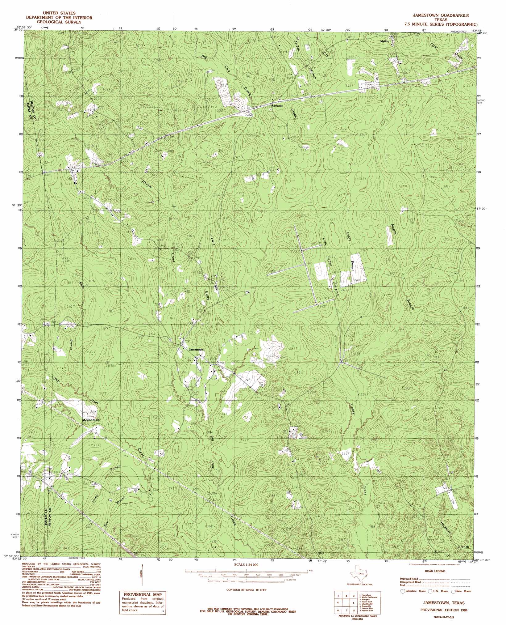
USGS Topo Quad 30093h7 - 1:24,000 scale
| Topo Map Name: | Jamestown |
| USGS Topo Quad ID: | 30093h7 |
| Print Size: | ca. 21 1/4" wide x 27" high |
| Southeast Coordinates: | 30.875° N latitude / 93.75° W longitude |
| Map Center Coordinates: | 30.9375° N latitude / 93.8125° W longitude |
| U.S. State: | TX |
| Filename: | o30093h7.jpg |
| Download Map JPG Image: | Jamestown topo map 1:24,000 scale |
| Map Type: | Topographic |
| Topo Series: | 7.5´ |
| Map Scale: | 1:24,000 |
| Source of Map Images: | United States Geological Survey (USGS) |
| Alternate Map Versions: |
Jamestown TX 1984, updated 1985 Download PDF Buy paper map Jamestown TX 2010 Download PDF Buy paper map Jamestown TX 2012 Download PDF Buy paper map Jamestown TX 2016 Download PDF Buy paper map |
1:24,000 Topo Quads surrounding Jamestown
Buck Bay |
Pineland South |
Hurricane Creek |
Fairmount |
Haddens |
Mcgee Bend |
Harrisburg |
Weeks Settlement |
Wiergate |
Wiergate Se |
Jasper West |
Jasper East |
Jamestown |
Shankleville |
Evans |
Beech Grove |
Roganville |
Newton West |
Newton East |
Merryville North |
Magnolia Springs |
Kirbyville |
Bleakwood |
Bon Wier |
Merryville South |
> Back to 30093e1 at 1:100,000 scale
> Back to 30092a1 at 1:250,000 scale
> Back to U.S. Topo Maps home
Jamestown topo map: Gazetteer
Jamestown: Populated Places
Farrsville elevation 80m 262′Jamestown elevation 72m 236′
Mattox elevation 94m 308′
Jamestown: Streams
Bay Branch elevation 58m 190′Blue Branch elevation 61m 200′
Caney Branch elevation 64m 209′
Dry Creek elevation 69m 226′
Fannie Branch elevation 61m 200′
Huff Creek elevation 62m 203′
Irving Branch elevation 58m 190′
Jordan Branch elevation 86m 282′
Little Caney Branch elevation 73m 239′
Martin Branch elevation 64m 209′
Jamestown: Valleys
Lewis Gully elevation 61m 200′Jamestown digital topo map on disk
Buy this Jamestown topo map showing relief, roads, GPS coordinates and other geographical features, as a high-resolution digital map file on DVD: