Mcgee Bend Topo Map Texas
To zoom in, hover over the map of Mcgee Bend
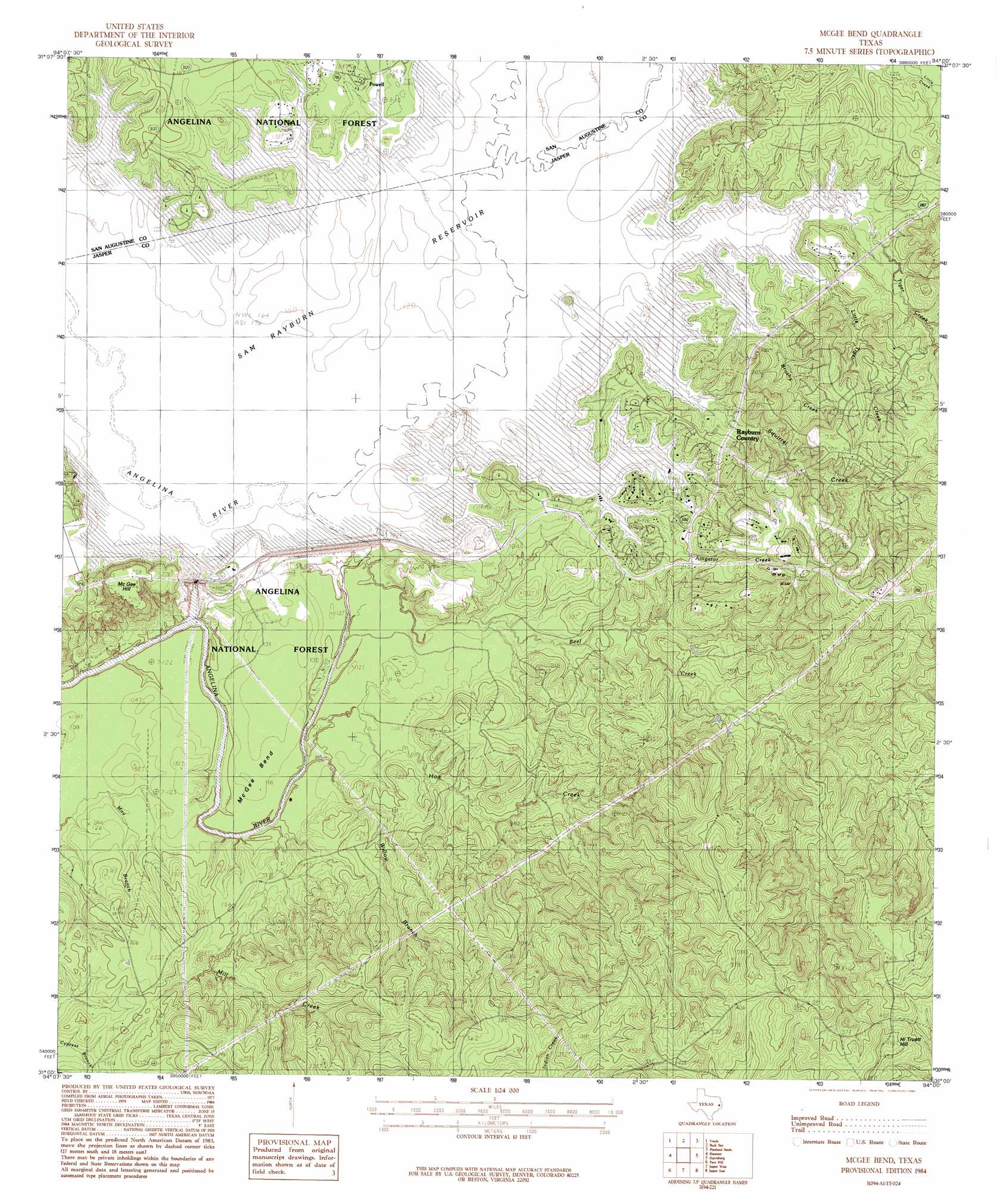
USGS Topo Quad 31094a1 - 1:24,000 scale
| Topo Map Name: | Mcgee Bend |
| USGS Topo Quad ID: | 31094a1 |
| Print Size: | ca. 21 1/4" wide x 27" high |
| Southeast Coordinates: | 31° N latitude / 94° W longitude |
| Map Center Coordinates: | 31.0625° N latitude / 94.0625° W longitude |
| U.S. State: | TX |
| Filename: | o31094a1.jpg |
| Download Map JPG Image: | Mcgee Bend topo map 1:24,000 scale |
| Map Type: | Topographic |
| Topo Series: | 7.5´ |
| Map Scale: | 1:24,000 |
| Source of Map Images: | United States Geological Survey (USGS) |
| Alternate Map Versions: |
McGee Bend TX 1984, updated 1984 Download PDF Buy paper map McGee Bend TX 2003, updated 2004 Download PDF Buy paper map McGee Bend TX 2010 Download PDF Buy paper map McGee Bend TX 2013 Download PDF Buy paper map McGee Bend TX 2016 Download PDF Buy paper map |
| FStopo: | US Forest Service topo McGee Bend is available: Download FStopo PDF Download FStopo TIF |
1:24,000 Topo Quads surrounding Mcgee Bend
Broaddus |
Harvey Creek |
Bronson |
Pineland North |
Hemphill |
Cassells-Boykin Park |
Veach |
Buck Bay |
Pineland South |
Hurricane Creek |
Boykin Spring |
Ebenezer |
Mcgee Bend |
Harrisburg |
Weeks Settlement |
Boggy Lake |
Pace Hill |
Jasper West |
Jasper East |
Jamestown |
Birdwell Lake |
Town Bluff |
Beech Grove |
Roganville |
Newton West |
> Back to 31094a1 at 1:100,000 scale
> Back to 31094a1 at 1:250,000 scale
> Back to U.S. Topo Maps home
Mcgee Bend topo map: Gazetteer
Mcgee Bend: Bends
McGee Bend elevation 36m 118′Mcgee Bend: Dams
Sam Rayburn Dam elevation 60m 196′Mcgee Bend: Parks
Twin Dikes Park elevation 52m 170′Mcgee Bend: Populated Places
Powell elevation 55m 180′Sam Rayburn elevation 61m 200′
Mcgee Bend: Reservoirs
Sam Rayburn Reservoir elevation 60m 196′Mcgee Bend: Streams
Alligator Creek elevation 50m 164′Bear Creek elevation 50m 164′
Beef Creek elevation 31m 101′
Big Branch elevation 50m 164′
Brushy Creek elevation 50m 164′
Drake Springs Branch elevation 50m 164′
Hog Creek elevation 28m 91′
Little Tiger Creek elevation 50m 164′
Meadows Branch elevation 50m 164′
Mill Creek elevation 26m 85′
Powell Branch elevation 50m 164′
Squirrel Creek elevation 50m 164′
Tiger Creek elevation 50m 164′
Willow Branch elevation 31m 101′
Mcgee Bend: Summits
Hi Truett Hill elevation 143m 469′McGee Hill elevation 78m 255′
Mcgee Bend digital topo map on disk
Buy this Mcgee Bend topo map showing relief, roads, GPS coordinates and other geographical features, as a high-resolution digital map file on DVD: