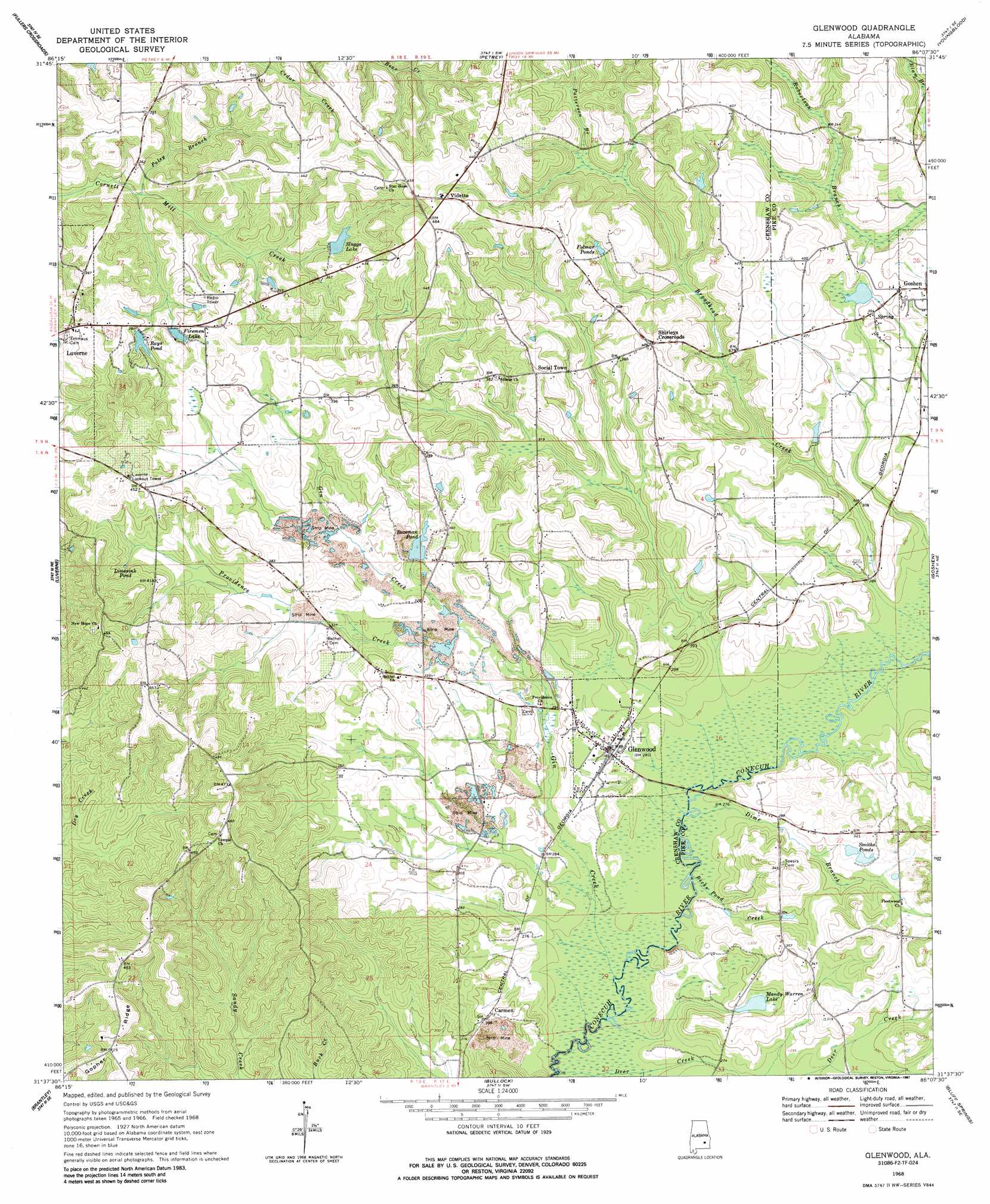
Glenwood Topo Map Alabama
To zoom in, hover over the map of Glenwood
USGS Topo Quad 31086f2 - 1:24,000 scale
| Topo Map Name: | Glenwood |
| USGS Topo Quad ID: | 31086f2 |
| Print Size: | ca. 21 1/4" wide x 27" high |
| Southeast Coordinates: | 31.625° N latitude / 86.125° W longitude |
| Map Center Coordinates: | 31.6875° N latitude / 86.1875° W longitude |
| U.S. State: | AL |
| Filename: | o31086f2.jpg |
| Download Map JPG Image: | Glenwood topo map 1:24,000 scale |
| Map Type: | Topographic |
| Topo Series: | 7.5´ |
| Map Scale: | 1:24,000 |
| Source of Map Images: | United States Geological Survey (USGS) |
| Alternate Map Versions: |
Glenwood AL 1968, updated 1970 Download PDF Buy paper map Glenwood AL 1968, updated 1987 Download PDF Buy paper map Glenwood AL 2011 Download PDF Buy paper map Glenwood AL 2014 Download PDF Buy paper map |
1:24,000 Topo Quads surrounding Glenwood
Danielsville |
Lapine |
Grady |
Ansley |
Needmore |
Honoraville |
Fullers Crossroads |
Petrey |
Youngblood |
Troy |
Moodys Crossroads |
Luverne |
Glenwood |
Goshen |
Brundidge Nw |
Leon |
Brantley |
Bullock |
Bluff Springs |
Victoria |
Gantt |
Dozier |
Danleys Crossroads |
Elba |
New Brockton |
> Back to 31086e1 at 1:100,000 scale
> Back to 31086a1 at 1:250,000 scale
> Back to U.S. Topo Maps home
Glenwood topo map: Gazetteer
Glenwood: Bridges
Speirs Bridge (historical) elevation 79m 259′Glenwood: Dams
Bozeman Pond Dam elevation 106m 347′Rays Pond Dam elevation 106m 347′
Sluggs Dam elevation 108m 354′
Glenwood: Lakes
Limesink Pond elevation 112m 367′Mandy Warren Lake elevation 90m 295′
Glenwood: Populated Places
Carmen elevation 92m 301′Glenwood elevation 85m 278′
Shirleys Crossroads elevation 122m 400′
Social Town elevation 117m 383′
Vidette elevation 143m 469′
Glenwood: Reservoirs
Bozeman Pond elevation 99m 324′Firemen Lake elevation 104m 341′
Folmer Ponds elevation 121m 396′
Rays Pond elevation 106m 347′
Sluggs Lake elevation 109m 357′
Smiths Ponds elevation 93m 305′
Glenwood: Ridges
Gopher Ridge elevation 119m 390′Glenwood: Streams
Becks Pond Creek elevation 79m 259′Cedar Creek elevation 80m 262′
Deer Creek elevation 76m 249′
Devilin Branch elevation 79m 259′
Dime Branch elevation 81m 265′
Gin Creek elevation 77m 252′
Patterson Branch elevation 106m 347′
Poley Branch elevation 90m 295′
Providence Creek elevation 94m 308′
Glenwood digital topo map on disk
Buy this Glenwood topo map showing relief, roads, GPS coordinates and other geographical features, as a high-resolution digital map file on DVD:
Gulf Coast (LA, MS, AL, FL) & Southwestern Georgia
Buy digital topo maps: Gulf Coast (LA, MS, AL, FL) & Southwestern Georgia
 & Southwestern Georgia map DVD")