Bilbo Island Topo Map Alabama
To zoom in, hover over the map of Bilbo Island
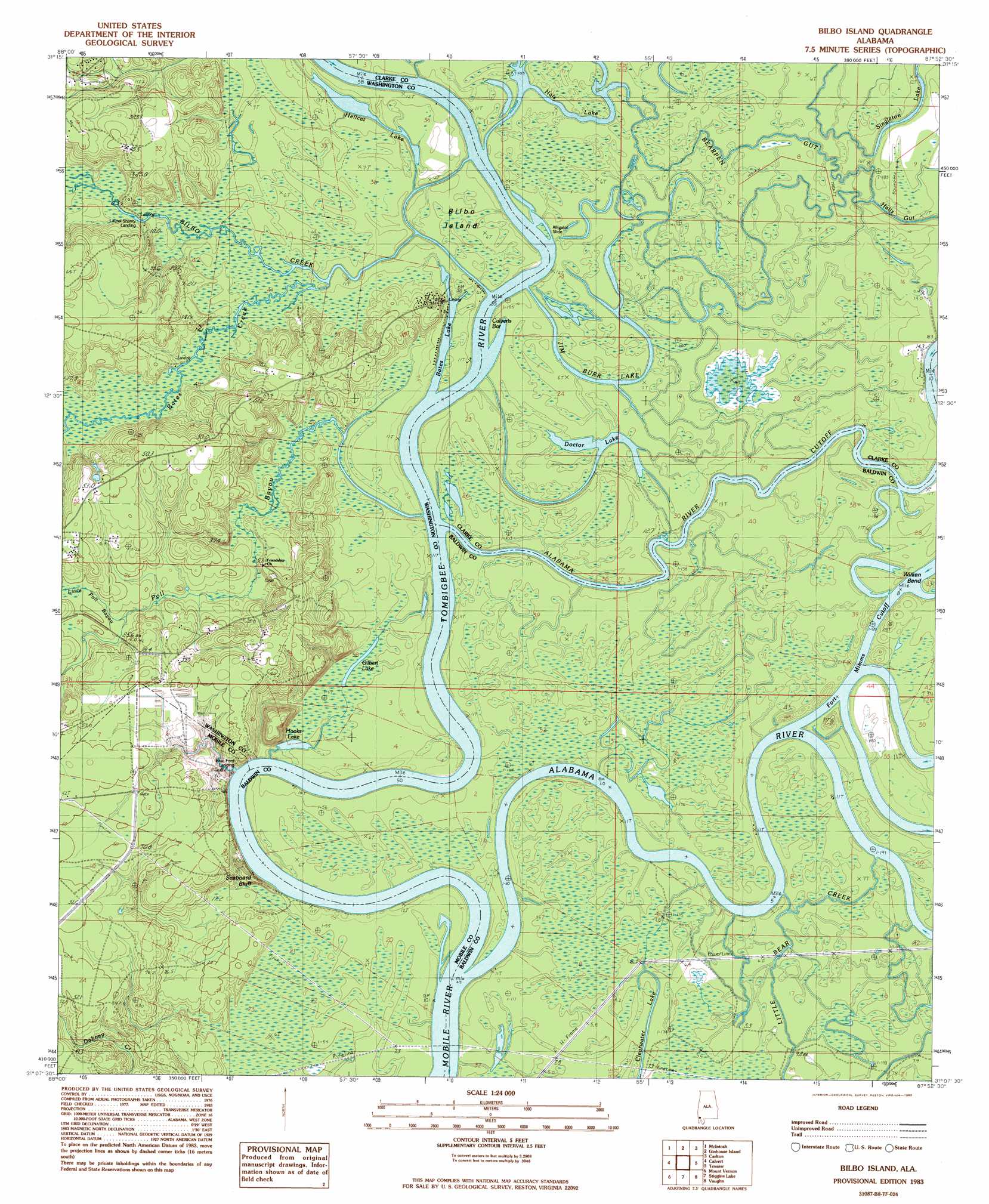
USGS Topo Quad 31087b8 - 1:24,000 scale
| Topo Map Name: | Bilbo Island |
| USGS Topo Quad ID: | 31087b8 |
| Print Size: | ca. 21 1/4" wide x 27" high |
| Southeast Coordinates: | 31.125° N latitude / 87.875° W longitude |
| Map Center Coordinates: | 31.1875° N latitude / 87.9375° W longitude |
| U.S. State: | AL |
| Filename: | o31087b8.jpg |
| Download Map JPG Image: | Bilbo Island topo map 1:24,000 scale |
| Map Type: | Topographic |
| Topo Series: | 7.5´ |
| Map Scale: | 1:24,000 |
| Source of Map Images: | United States Geological Survey (USGS) |
| Alternate Map Versions: |
Bilbo Island AL 1983, updated 1983 Download PDF Buy paper map Bilbo Island AL 1983, updated 1983 Download PDF Buy paper map Bilbo Island AL 2011 Download PDF Buy paper map Bilbo Island AL 2014 Download PDF Buy paper map |
1:24,000 Topo Quads surrounding Bilbo Island
Rutan |
Wagarville |
Prestwick |
Choctaw Bluff |
Gainestown |
Seaboard |
Mcintosh |
Gin House Island |
Carlton |
Chrysler |
Sims Chapel |
Calvert |
Bilbo Island |
Tensaw |
Blacksher |
Citronelle East |
Mount Vernon |
Stiggins Lake |
Vaughn |
Perdido |
Chunchula |
Creola |
The Basin |
Bay Minette North |
Dyas |
> Back to 31087a1 at 1:100,000 scale
> Back to 31086a1 at 1:250,000 scale
> Back to U.S. Topo Maps home
Bilbo Island topo map: Gazetteer
Bilbo Island: Bars
Calverts Bar elevation 2m 6′Bilbo Island: Bends
Wilken Bend elevation 2m 6′Bilbo Island: Cliffs
Nanahubba Bluff elevation 9m 29′Seaboard Bluff elevation 13m 42′
Bilbo Island: Guts
Alabama River Cutoff elevation 1m 3′Alligator Slide elevation 2m 6′
Bear Creek elevation 2m 6′
Bearpen Gut elevation 2m 6′
Deep Slough elevation 2m 6′
Horsepen Creek elevation 2m 6′
Joe Bayou elevation 2m 6′
Woodyard Gut elevation 2m 6′
Bilbo Island: Islands
Bilbo Island elevation 2m 6′Jim Burns Island elevation 2m 6′
Bilbo Island: Lakes
Bates Lake elevation 1m 3′Clearwater Lake elevation 2m 6′
Doctor Lake elevation 1m 3′
Gilbert Lake elevation 2m 6′
Hellcat Lake elevation 1m 3′
Hooks Lake elevation 2m 6′
Jim Burr Lake elevation 2m 6′
Singleton Lake elevation 1m 3′
Turpin Slough elevation 2m 6′
Bilbo Island: Streams
Alabama River elevation 1m 3′Bates Creek elevation 2m 6′
Bilbo Creek elevation 2m 6′
Griers Creek elevation 2m 6′
Little Poll Bayou elevation 6m 19′
Poll Bayou elevation 2m 6′
Tombigbee River elevation 1m 3′
Tombigbee River elevation 1m 3′
West River elevation 1m 3′
Bilbo Island digital topo map on disk
Buy this Bilbo Island topo map showing relief, roads, GPS coordinates and other geographical features, as a high-resolution digital map file on DVD:
Gulf Coast (LA, MS, AL, FL) & Southwestern Georgia
Buy digital topo maps: Gulf Coast (LA, MS, AL, FL) & Southwestern Georgia
 & Southwestern Georgia map DVD")