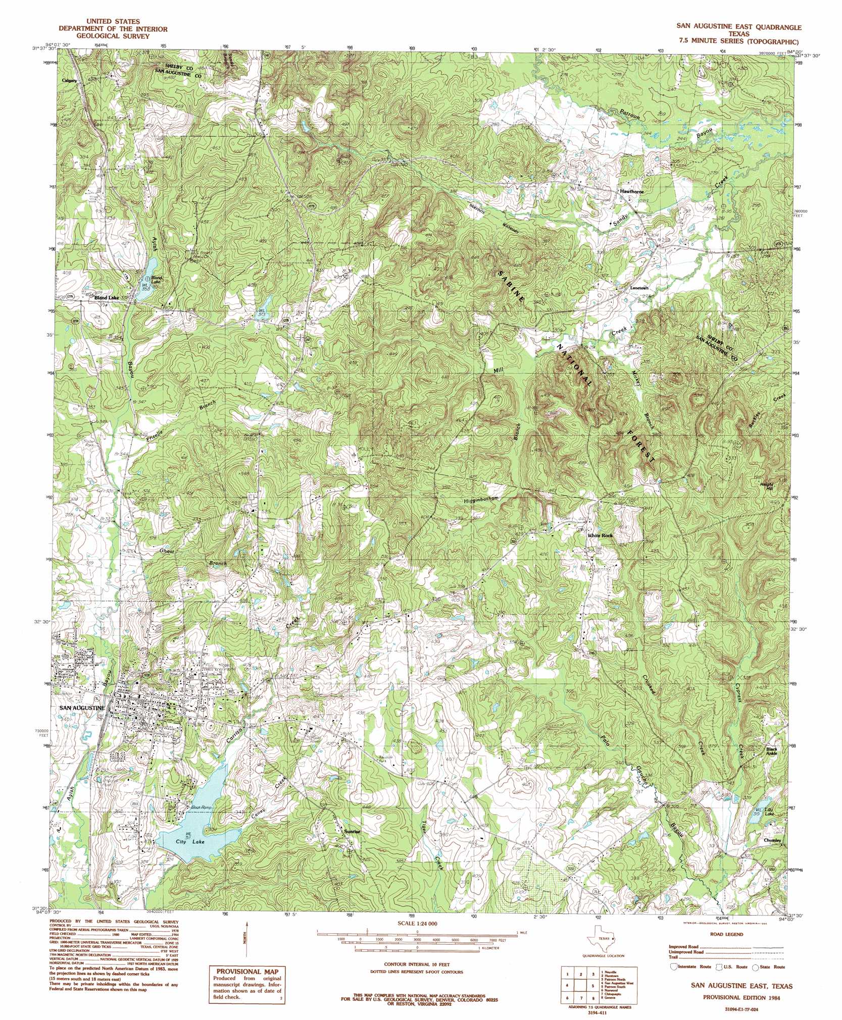
San Augustine East Topo Map Texas
To zoom in, hover over the map of San Augustine East
USGS Topo Quad 31094e1 - 1:24,000 scale
| Topo Map Name: | San Augustine East |
| USGS Topo Quad ID: | 31094e1 |
| Print Size: | ca. 21 1/4" wide x 27" high |
| Southeast Coordinates: | 31.5° N latitude / 94° W longitude |
| Map Center Coordinates: | 31.5625° N latitude / 94.0625° W longitude |
| U.S. State: | TX |
| Filename: | o31094e1.jpg |
| Download Map JPG Image: | San Augustine East topo map 1:24,000 scale |
| Map Type: | Topographic |
| Topo Series: | 7.5´ |
| Map Scale: | 1:24,000 |
| Source of Map Images: | United States Geological Survey (USGS) |
| Alternate Map Versions: |
San Augustine East TX 1984, updated 1985 Download PDF Buy paper map San Augustine East TX 2003, updated 2004 Download PDF Buy paper map San Augustine East TX 2010 Download PDF Buy paper map San Augustine East TX 2013 Download PDF Buy paper map San Augustine East TX 2016 Download PDF Buy paper map |
| FStopo: | US Forest Service topo San Augustine East is available: Download FStopo PDF Download FStopo TIF |
1:24,000 Topo Quads surrounding San Augustine East
Arcadia |
Center |
Shelbyville |
Huxley |
Union Springs |
Mount Herman |
Neuville |
Hurstown |
Patroon North |
Brushy Creek |
Chireno North |
San Augustine West |
San Augustine East |
Patroon South |
East Hamilton |
Chireno South |
Norwood |
Chinquapin |
Geneva |
Milam |
Broaddus |
Harvey Creek |
Bronson |
Pineland North |
Hemphill |
> Back to 31094e1 at 1:100,000 scale
> Back to 31094a1 at 1:250,000 scale
> Back to U.S. Topo Maps home
San Augustine East topo map: Gazetteer
San Augustine East: Dams
Bland Lake Dam elevation 108m 354′Lilly Lake Dam elevation 95m 311′
San Augustine City Lake Dam elevation 86m 282′
San Augustine East: Lakes
City Lake elevation 95m 311′San Augustine East: Populated Places
Black Ankle elevation 117m 383′Bland Lake elevation 112m 367′
Calgary elevation 139m 456′
Chumley elevation 99m 324′
Hawthorne elevation 88m 288′
Lanetown elevation 92m 301′
San Augustine elevation 113m 370′
Sunrise elevation 133m 436′
White Rock elevation 137m 449′
San Augustine East: Reservoirs
Bland Lake elevation 109m 357′Lilly Lake elevation 117m 383′
San Augustine City Lake elevation 86m 282′
San Augustine East: Springs
San Augustine Spring elevation 108m 354′San Augustine Spring elevation 138m 452′
San Augustine Spring elevation 117m 383′
San Augustine East: Streams
Caney Creek elevation 95m 311′Crooked Creek elevation 88m 288′
Cypress Creek elevation 87m 285′
Frizelle Branch elevation 102m 334′
Ghost Branch elevation 99m 324′
Higginbotham Branch elevation 94m 308′
Mickey Branch elevation 85m 278′
Mill Creek elevation 74m 242′
San Augustine East: Summits
Height Hill elevation 151m 495′Hieght Hill elevation 156m 511′
San Augustine East digital topo map on disk
Buy this San Augustine East topo map showing relief, roads, GPS coordinates and other geographical features, as a high-resolution digital map file on DVD: