Brady Sw Topo Map Texas
To zoom in, hover over the map of Brady Sw
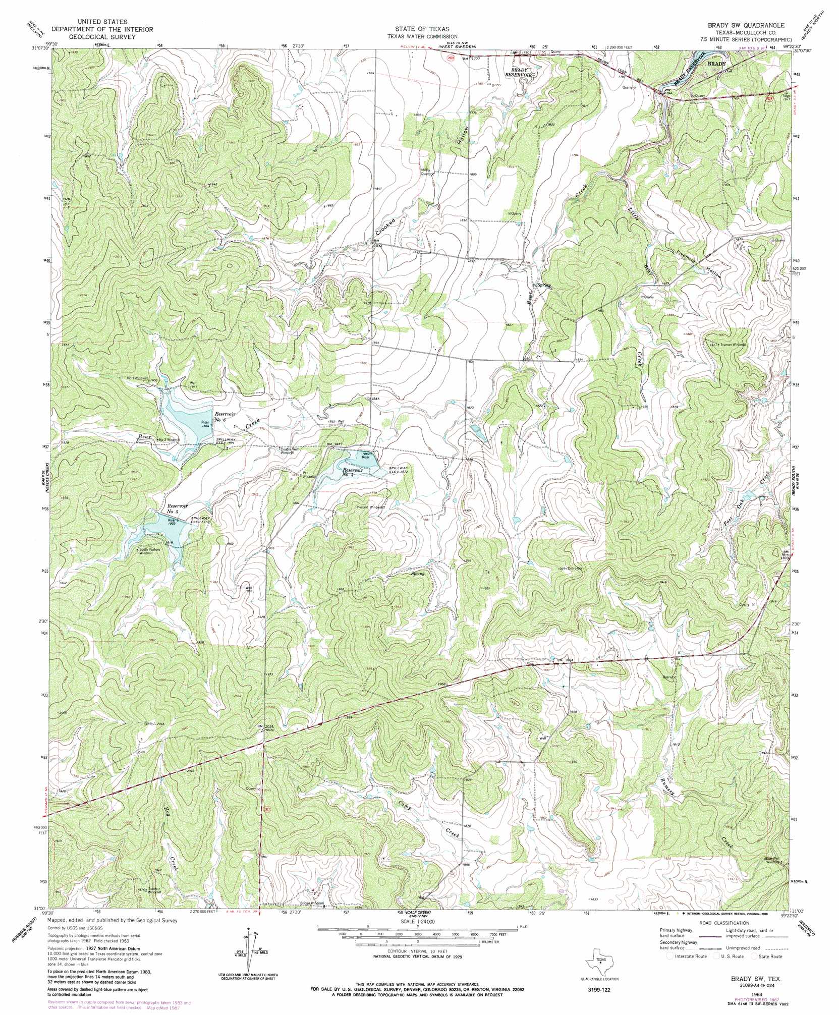
USGS Topo Quad 31099a4 - 1:24,000 scale
| Topo Map Name: | Brady Sw |
| USGS Topo Quad ID: | 31099a4 |
| Print Size: | ca. 21 1/4" wide x 27" high |
| Southeast Coordinates: | 31° N latitude / 99.375° W longitude |
| Map Center Coordinates: | 31.0625° N latitude / 99.4375° W longitude |
| U.S. State: | TX |
| Filename: | o31099a4.jpg |
| Download Map JPG Image: | Brady Sw topo map 1:24,000 scale |
| Map Type: | Topographic |
| Topo Series: | 7.5´ |
| Map Scale: | 1:24,000 |
| Source of Map Images: | United States Geological Survey (USGS) |
| Alternate Map Versions: |
Brady SW TX 1963, updated 1964 Download PDF Buy paper map Brady SW TX 1963, updated 1988 Download PDF Buy paper map Brady SW TX 2010 Download PDF Buy paper map Brady SW TX 2013 Download PDF Buy paper map Brady SW TX 2016 Download PDF Buy paper map |
1:24,000 Topo Quads surrounding Brady Sw
Doole Sw |
Salt Gap |
Lohn |
Bluff Creek |
Placid |
Pasche |
Melvin |
West Sweden |
Brady North |
Rochelle |
Callan |
Needle Creek |
Brady Sw |
Brady South |
Voca |
Chapman Draw |
Robbers Roost |
Calf Creek |
Katemcy |
Spy Rock |
East Elm Creek |
Hext |
Long Mountain |
Grit |
Purdy Hill |
> Back to 31099a1 at 1:100,000 scale
> Back to 31098a1 at 1:250,000 scale
> Back to U.S. Topo Maps home
Brady Sw topo map: Gazetteer
Brady Sw: Dams
Soil Conservation Service Site 4 Dam elevation 564m 1850′Soil Conservation Service Site 5 Dam elevation 581m 1906′
Soil Conservation Service Site 6 Dam elevation 583m 1912′
Brady Sw: Reservoirs
Brady Reservoir elevation 531m 1742′Reservoir Number Five elevation 581m 1906′
Reservoir Number Four elevation 570m 1870′
Reservoir Number Six elevation 574m 1883′
Soil Conservation Service Site 4 Reservoir elevation 564m 1850′
Soil Conservation Service Site 5 Reservoir elevation 581m 1906′
Soil Conservation Service Site 6 Reservoir elevation 583m 1912′
Brady Sw: Streams
Little Bear Creek elevation 532m 1745′Brady Sw: Valleys
Fivemile Hollow elevation 544m 1784′Brady Sw digital topo map on disk
Buy this Brady Sw topo map showing relief, roads, GPS coordinates and other geographical features, as a high-resolution digital map file on DVD: