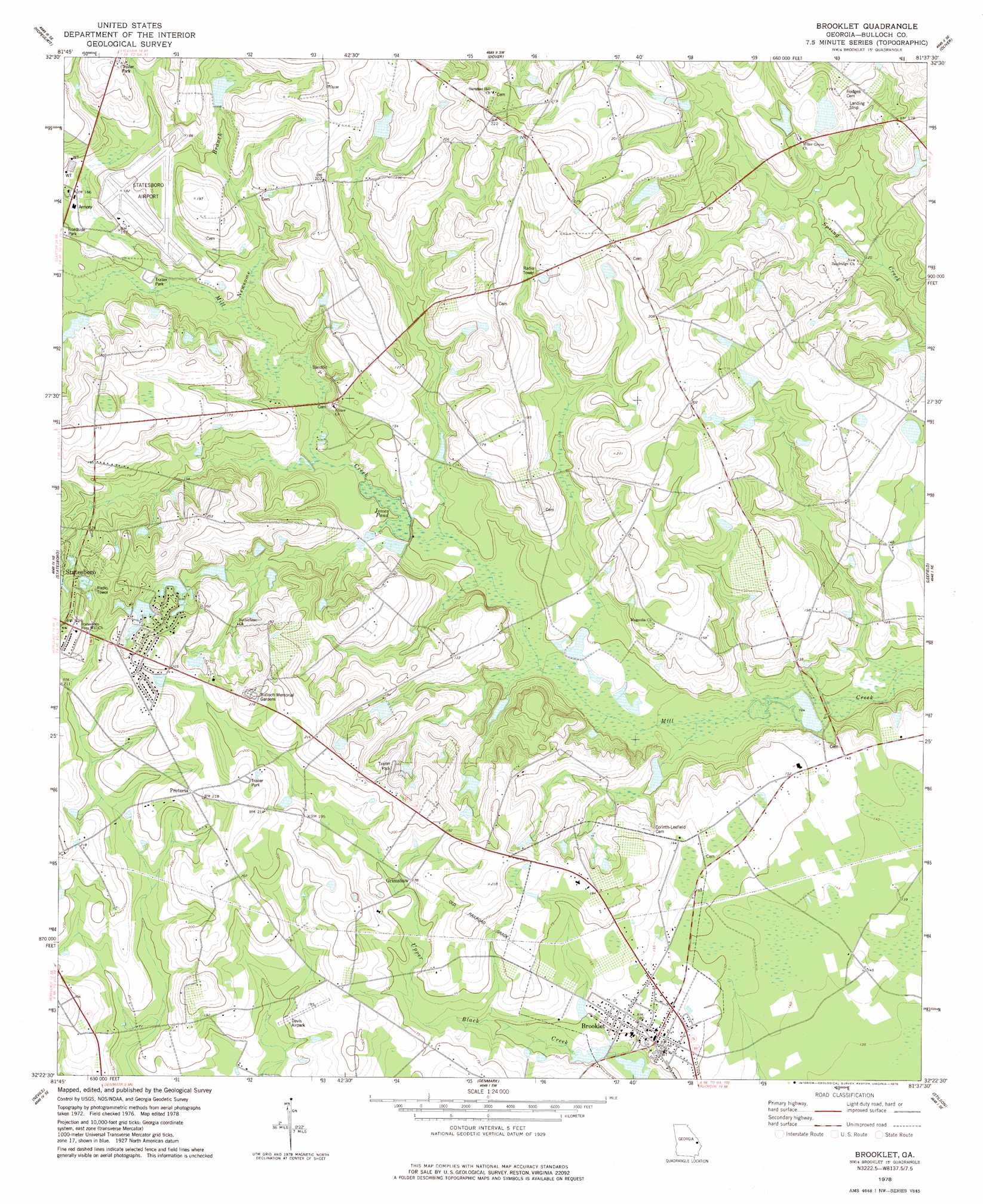
Brooklet Topo Map Georgia
To zoom in, hover over the map of Brooklet
USGS Topo Quad 32081d6 - 1:24,000 scale
| Topo Map Name: | Brooklet |
| USGS Topo Quad ID: | 32081d6 |
| Print Size: | ca. 21 1/4" wide x 27" high |
| Southeast Coordinates: | 32.375° N latitude / 81.625° W longitude |
| Map Center Coordinates: | 32.4375° N latitude / 81.6875° W longitude |
| U.S. State: | GA |
| Filename: | o32081d6.jpg |
| Download Map JPG Image: | Brooklet topo map 1:24,000 scale |
| Map Type: | Topographic |
| Topo Series: | 7.5´ |
| Map Scale: | 1:24,000 |
| Source of Map Images: | United States Geological Survey (USGS) |
| Alternate Map Versions: |
Brooklet GA 1978, updated 1978 Download PDF Buy paper map Brooklet GA 2011 Download PDF Buy paper map Brooklet GA 2014 Download PDF Buy paper map |
1:24,000 Topo Quads surrounding Brooklet
Four Points |
Rocky Ford |
Sylvania South |
Hunters |
Blue Springs Landing |
Portal |
Hopeulikit |
Dover |
Oliver |
Kildare |
Pulaski |
Statesboro |
Brooklet |
Leefield |
Egypt |
Register |
Nevils |
Denmark |
Stilson |
Guyton |
Claxton |
Daisy |
Groveland |
Lanier |
Eden |
> Back to 32081a1 at 1:100,000 scale
> Back to 32080a1 at 1:250,000 scale
> Back to U.S. Topo Maps home
Brooklet topo map: Gazetteer
Brooklet: Airports
Brooklet Airpark elevation 58m 190′Statesboro Municipal Airport elevation 52m 170′
Brooklet: Dams
Lee Pond Dam elevation 37m 121′Youngblood Pond Dam elevation 31m 101′
Brooklet: Lakes
Jones Pond elevation 37m 121′Brooklet: Populated Places
Brians Chase elevation 68m 223′Brooklet elevation 46m 150′
Colonial Heights elevation 72m 236′
English Oaks Community Mobile Home Park elevation 55m 180′
Grimshaw elevation 54m 177′
Grove Lakes elevation 67m 219′
Grove Lakes South elevation 71m 232′
Merrywood elevation 65m 213′
Mill Creek (historical) elevation 39m 127′
Plantation Mobile Home Estates elevation 60m 196′
Pretoria elevation 67m 219′
Windfield elevation 60m 196′
Brooklet: Post Offices
Brooklet Post Office elevation 47m 154′Brooklet: Reservoirs
Lee Pond elevation 37m 121′Martin Pond elevation 48m 157′
Youngblood Pond elevation 31m 101′
Brooklet: Streams
Newsome Branch elevation 41m 134′Brooklet digital topo map on disk
Buy this Brooklet topo map showing relief, roads, GPS coordinates and other geographical features, as a high-resolution digital map file on DVD:
South Carolina, Western North Carolina & Northeastern Georgia
Buy digital topo maps: South Carolina, Western North Carolina & Northeastern Georgia