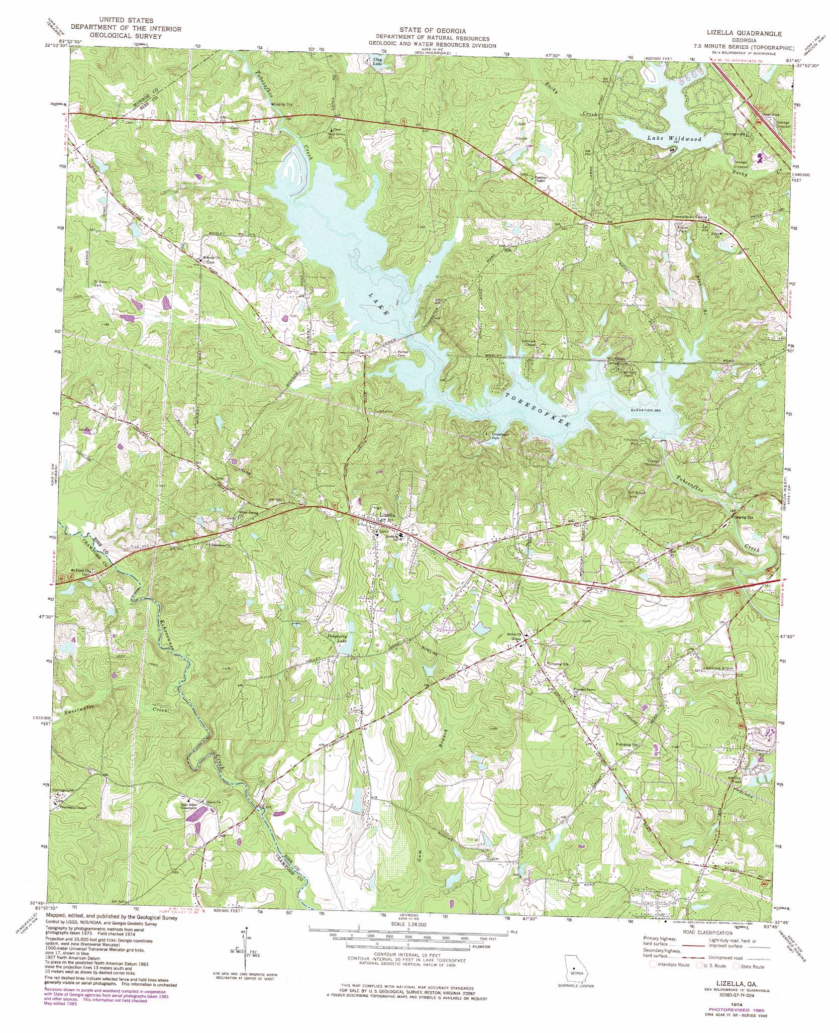
Lizella Topo Map Georgia
To zoom in, hover over the map of Lizella
USGS Topo Quad 32083g7 - 1:24,000 scale
| Topo Map Name: | Lizella |
| USGS Topo Quad ID: | 32083g7 |
| Print Size: | ca. 21 1/4" wide x 27" high |
| Southeast Coordinates: | 32.75° N latitude / 83.75° W longitude |
| Map Center Coordinates: | 32.8125° N latitude / 83.8125° W longitude |
| U.S. State: | GA |
| Filename: | o32083g7.jpg |
| Download Map JPG Image: | Lizella topo map 1:24,000 scale |
| Map Type: | Topographic |
| Topo Series: | 7.5´ |
| Map Scale: | 1:24,000 |
| Source of Map Images: | United States Geological Survey (USGS) |
| Alternate Map Versions: |
Lizella GA 1974, updated 1976 Download PDF Buy paper map Lizella GA 1974, updated 1985 Download PDF Buy paper map Lizella GA 2011 Download PDF Buy paper map Lizella GA 2014 Download PDF Buy paper map |
1:24,000 Topo Quads surrounding Lizella
Johnstonville |
Forsyth |
East Juliette |
Dames Ferry |
Gray |
Strouds |
Smarr |
Bolingbroke |
Macon Nw |
Macon Ne |
Culloden |
Moran |
Lizella |
Macon West |
Macon East |
Roberta |
Knoxville |
Byron |
Warner Robins Nw |
Warner Robins Ne |
Reynolds |
Fort Valley West |
Fort Valley East |
Warner Robins Sw |
Warner Robins Se |
> Back to 32083e1 at 1:100,000 scale
> Back to 32082a1 at 1:250,000 scale
> Back to U.S. Topo Maps home
Lizella topo map: Gazetteer
Lizella: Dams
Clay South Dam elevation 136m 446′Dougherty Lake Dam elevation 139m 456′
Fenley Ryther Dam elevation 110m 360′
Lake Wildwood Dam elevation 122m 400′
Stackler Lake Dam elevation 118m 387′
Lizella: Parks
Arrowhead Park elevation 118m 387′Claystone Park elevation 120m 393′
Flintrock Park elevation 118m 387′
Sandy Beach Park elevation 125m 410′
Lizella: Populated Places
Angels Acres elevation 121m 396′Beaveroaks elevation 130m 426′
Blanton Acres elevation 157m 515′
Camelot elevation 141m 462′
Cherokee elevation 137m 449′
Christophers Cove elevation 122m 400′
Dixie elevation 125m 410′
Dogwood Plantation elevation 152m 498′
Kings Cove elevation 151m 495′
Lakeview elevation 125m 410′
Lizella elevation 171m 561′
Phelps Estates elevation 142m 465′
Pineworth by the Lake elevation 115m 377′
Rockmill (historical) elevation 112m 367′
Rogers Acres elevation 126m 413′
Shadowood elevation 156m 511′
Sherwood Forest elevation 129m 423′
Sofkee Estates elevation 160m 524′
Tara elevation 126m 413′
Trails End elevation 149m 488′
West Point elevation 145m 475′
Whispering Pines elevation 126m 413′
Lizella: Reservoirs
Clay Lake elevation 135m 442′Clay South Lake elevation 136m 446′
Dougherty Lake elevation 139m 456′
Lake Tobesofkee elevation 110m 360′
Lake Wildwood elevation 122m 400′
Stackler Lake elevation 118m 387′
Tobesofkee Creek Structure Number One L elevation 110m 360′
Lizella: Streams
Blue Branch elevation 110m 360′Sweetwater Creek elevation 105m 344′
Lizella digital topo map on disk
Buy this Lizella topo map showing relief, roads, GPS coordinates and other geographical features, as a high-resolution digital map file on DVD:
South Carolina, Western North Carolina & Northeastern Georgia
Buy digital topo maps: South Carolina, Western North Carolina & Northeastern Georgia