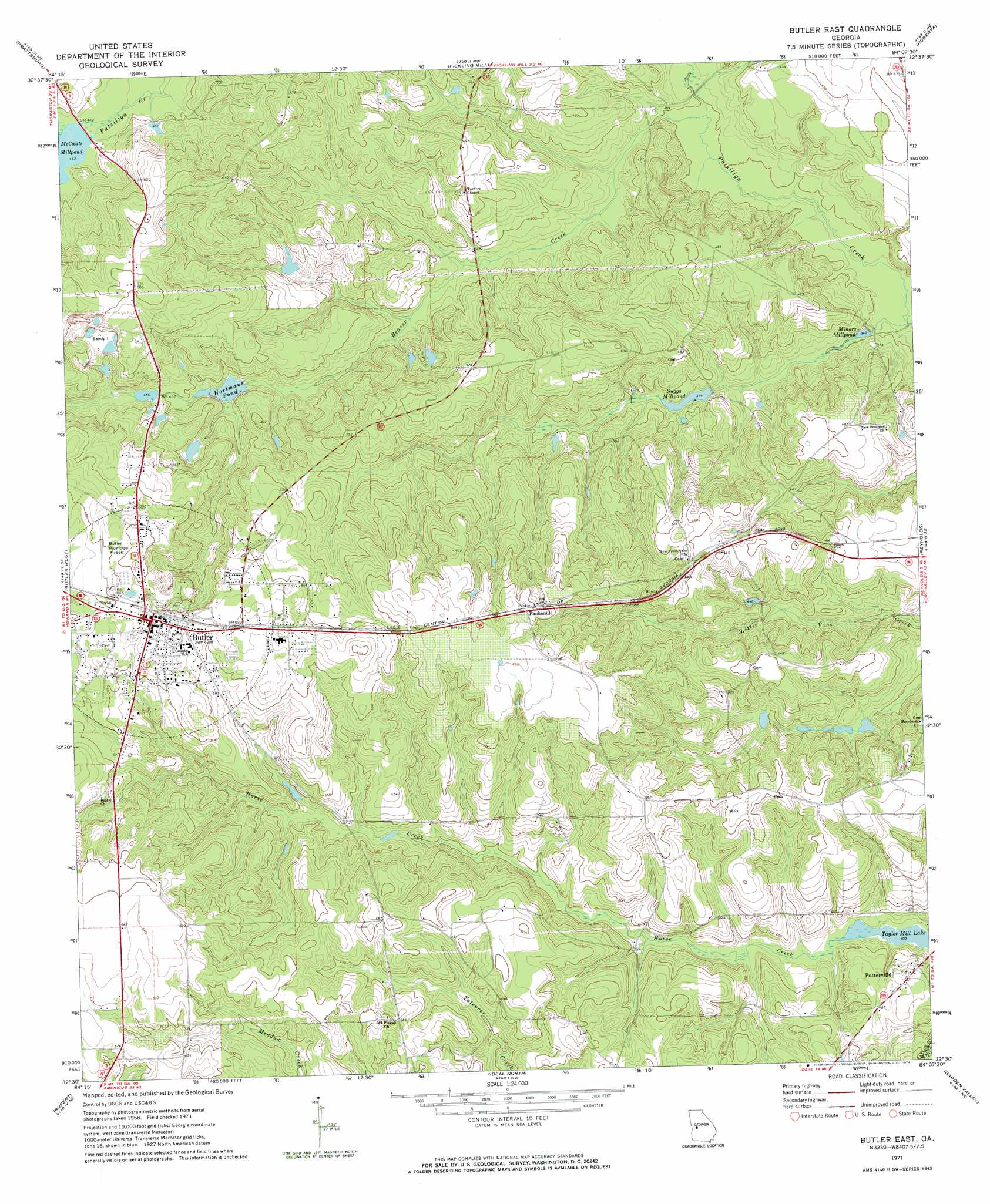
Butler East Topo Map Georgia
To zoom in, hover over the map of Butler East
USGS Topo Quad 32084e2 - 1:24,000 scale
| Topo Map Name: | Butler East |
| USGS Topo Quad ID: | 32084e2 |
| Print Size: | ca. 21 1/4" wide x 27" high |
| Southeast Coordinates: | 32.5° N latitude / 84.125° W longitude |
| Map Center Coordinates: | 32.5625° N latitude / 84.1875° W longitude |
| U.S. State: | GA |
| Filename: | o32084e2.jpg |
| Download Map JPG Image: | Butler East topo map 1:24,000 scale |
| Map Type: | Topographic |
| Topo Series: | 7.5´ |
| Map Scale: | 1:24,000 |
| Source of Map Images: | United States Geological Survey (USGS) |
| Alternate Map Versions: |
Butler East GA 1971, updated 1974 Download PDF Buy paper map Butler East GA 2011 Download PDF Buy paper map Butler East GA 2014 Download PDF Buy paper map |
1:24,000 Topo Quads surrounding Butler East
Roland |
Lincoln Park |
Logtown |
Culloden |
Moran |
Baldwinville |
Prattsburg |
Fickling Mill |
Roberta |
Knoxville |
Junction City |
Butler West |
Butler East |
Reynolds |
Fort Valley West |
Tazewell North |
Rupert |
Ideal North |
Garden Valley |
Marshallville |
Tazewell South |
Ellaville North |
Ideal South |
Montezuma |
Marshallville Sw |
> Back to 32084e1 at 1:100,000 scale
> Back to 32084a1 at 1:250,000 scale
> Back to U.S. Topo Maps home
Butler East topo map: Gazetteer
Butler East: Dams
Garant Lake Dam elevation 131m 429′Hinton Lake Dam elevation 143m 469′
Hortmans Pond Dam elevation 130m 426′
Butler East: Populated Places
Butler elevation 196m 643′Panhandle elevation 183m 600′
Butler East: Reservoirs
Garant Lake elevation 131m 429′Hinton Lake elevation 143m 469′
Hortmans Pond elevation 130m 426′
McCants Millpond elevation 134m 439′
Minors Millpond elevation 105m 344′
Suggs Millpond elevation 114m 374′
Taylor Mill Lake elevation 123m 403′
Butler East: Streams
Beaver Creek elevation 106m 347′Butler East digital topo map on disk
Buy this Butler East topo map showing relief, roads, GPS coordinates and other geographical features, as a high-resolution digital map file on DVD:
Gulf Coast (LA, MS, AL, FL) & Southwestern Georgia
Buy digital topo maps: Gulf Coast (LA, MS, AL, FL) & Southwestern Georgia
 & Southwestern Georgia map DVD")