Garden Valley Topo Map Georgia
To zoom in, hover over the map of Garden Valley
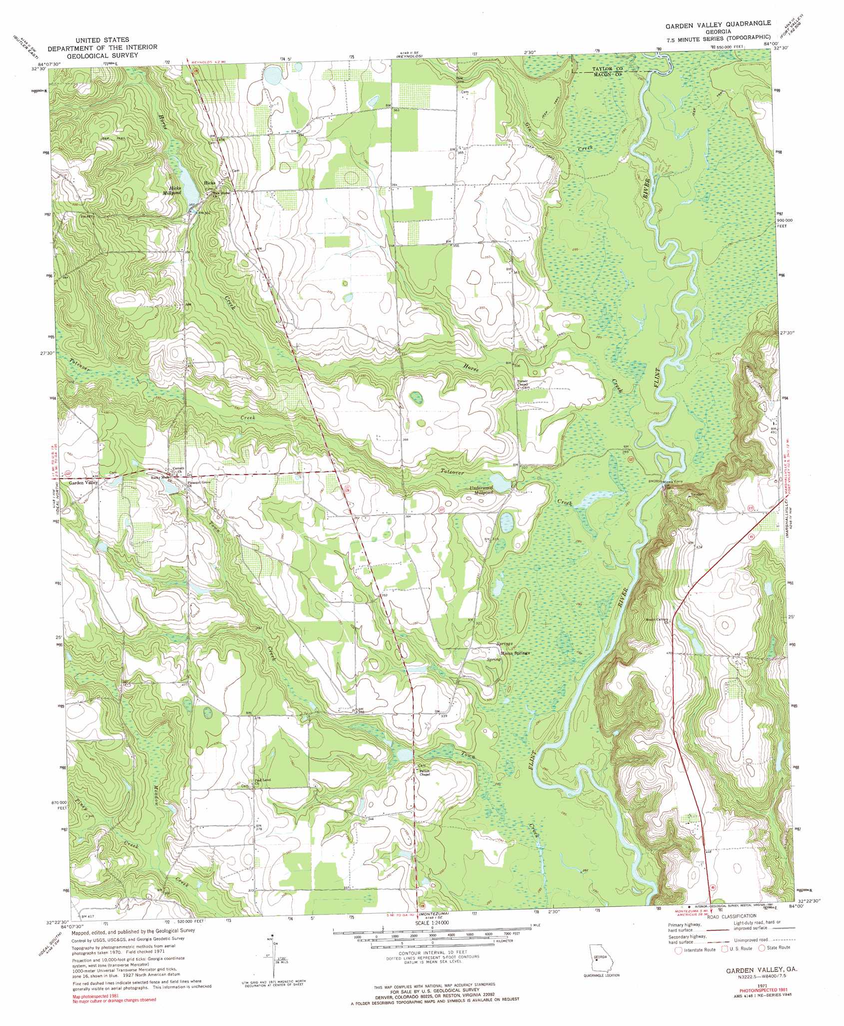
USGS Topo Quad 32084d1 - 1:24,000 scale
| Topo Map Name: | Garden Valley |
| USGS Topo Quad ID: | 32084d1 |
| Print Size: | ca. 21 1/4" wide x 27" high |
| Southeast Coordinates: | 32.375° N latitude / 84° W longitude |
| Map Center Coordinates: | 32.4375° N latitude / 84.0625° W longitude |
| U.S. State: | GA |
| Filename: | o32084d1.jpg |
| Download Map JPG Image: | Garden Valley topo map 1:24,000 scale |
| Map Type: | Topographic |
| Topo Series: | 7.5´ |
| Map Scale: | 1:24,000 |
| Source of Map Images: | United States Geological Survey (USGS) |
| Alternate Map Versions: |
Garden Valley GA 1971, updated 1974 Download PDF Buy paper map Garden Valley GA 1971, updated 1991 Download PDF Buy paper map Garden Valley GA 2011 Download PDF Buy paper map Garden Valley GA 2014 Download PDF Buy paper map |
1:24,000 Topo Quads surrounding Garden Valley
Prattsburg |
Fickling Mill |
Roberta |
Knoxville |
Byron |
Butler West |
Butler East |
Reynolds |
Fort Valley West |
Fort Valley East |
Rupert |
Ideal North |
Garden Valley |
Marshallville |
Perry West |
Ellaville North |
Ideal South |
Montezuma |
Marshallville Sw |
Henderson |
Ellaville South |
Andersonville |
Pennington |
Byromville |
Pinehurst |
> Back to 32084a1 at 1:100,000 scale
> Back to 32084a1 at 1:250,000 scale
> Back to U.S. Topo Maps home
Garden Valley topo map: Gazetteer
Garden Valley: Dams
Hartman Lake Dam elevation 121m 396′Hicks Millpond Dam elevation 110m 360′
Garden Valley: Populated Places
Garden Valley elevation 133m 436′Hicks elevation 131m 429′
Garden Valley: Reservoirs
Hartman Lake elevation 121m 396′Hicks Millpond elevation 110m 360′
Underwood Millpond elevation 91m 298′
Garden Valley: Springs
Miona Springs elevation 89m 291′Garden Valley: Streams
Beaver Creek elevation 88m 288′Gin Creek elevation 88m 288′
Horse Creek elevation 85m 278′
Piney Creek elevation 98m 321′
Toteover Creek elevation 85m 278′
Garden Valley: Swamps
Bryants Swamp elevation 87m 285′Garden Valley digital topo map on disk
Buy this Garden Valley topo map showing relief, roads, GPS coordinates and other geographical features, as a high-resolution digital map file on DVD:
Gulf Coast (LA, MS, AL, FL) & Southwestern Georgia
Buy digital topo maps: Gulf Coast (LA, MS, AL, FL) & Southwestern Georgia
 & Southwestern Georgia map DVD")