Kilgore Ne Topo Map Texas
To zoom in, hover over the map of Kilgore Ne
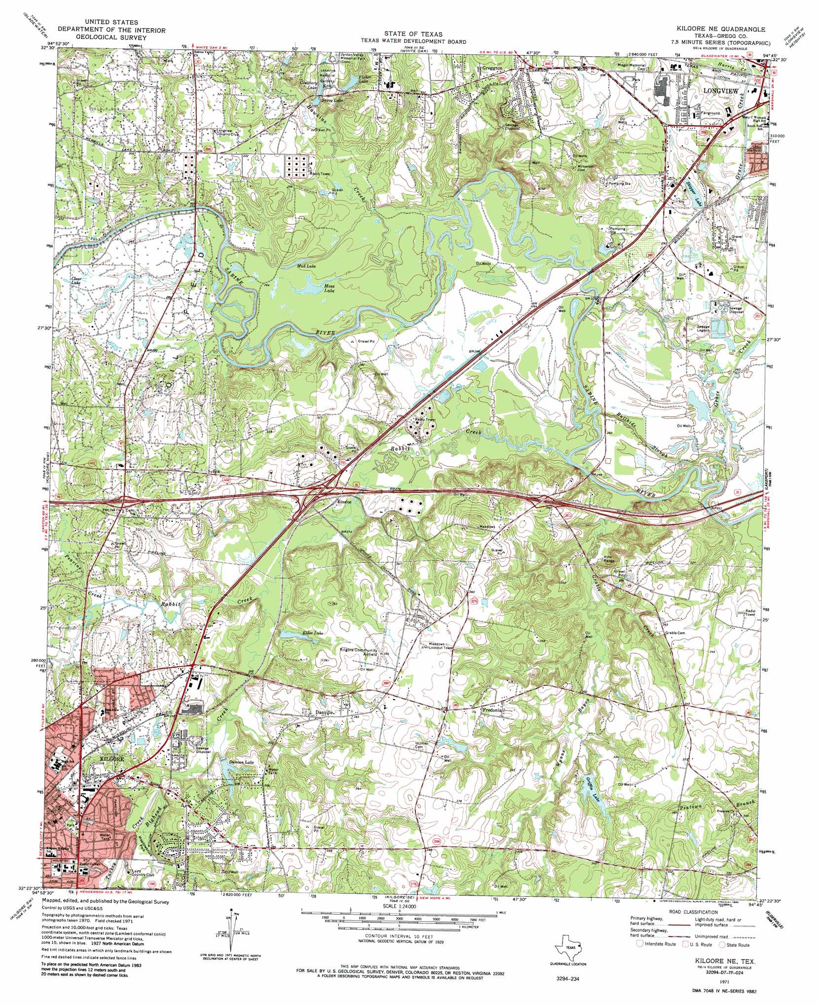
USGS Topo Quad 32094d7 - 1:24,000 scale
| Topo Map Name: | Kilgore Ne |
| USGS Topo Quad ID: | 32094d7 |
| Print Size: | ca. 21 1/4" wide x 27" high |
| Southeast Coordinates: | 32.375° N latitude / 94.75° W longitude |
| Map Center Coordinates: | 32.4375° N latitude / 94.8125° W longitude |
| U.S. State: | TX |
| Filename: | o32094d7.jpg |
| Download Map JPG Image: | Kilgore Ne topo map 1:24,000 scale |
| Map Type: | Topographic |
| Topo Series: | 7.5´ |
| Map Scale: | 1:24,000 |
| Source of Map Images: | United States Geological Survey (USGS) |
| Alternate Map Versions: |
Kilgore NE TX 1971, updated 1974 Download PDF Buy paper map Kilgore NE TX 1971, updated 1985 Download PDF Buy paper map Kilgore NE TX 2010 Download PDF Buy paper map Kilgore NE TX 2013 Download PDF Buy paper map Kilgore NE TX 2016 Download PDF Buy paper map |
1:24,000 Topo Quads surrounding Kilgore Ne
Pritchett |
Gilmer |
Glenwood |
Ashland |
Harleton |
Big Sandy |
Gladewater |
White Oak |
Longview Heights |
Hallsville |
Starrville |
Kilgore Nw |
Kilgore Ne |
Lakeport |
Easton |
Hope Pond |
Kilgore Sw |
Kilgore Se |
Elderville |
Tatum |
Troup East |
Price |
Henderson |
Church Hill |
Fair Play |
> Back to 32094a1 at 1:100,000 scale
> Back to 32094a1 at 1:250,000 scale
> Back to U.S. Topo Maps home
Kilgore Ne topo map: Gazetteer
Kilgore Ne: Airports
Kilgore Airport elevation 108m 354′Kilgore Ne: Dams
Duncan Lake Dam elevation 91m 298′Griffin Dam elevation 104m 341′
Griffin Lake Dam elevation 104m 341′
Kilgore Dam elevation 88m 288′
Low Head Weir Dam elevation 72m 236′
Wickham Dam elevation 95m 311′
Kilgore Ne: Guts
Bullhide Slough elevation 76m 249′Kilgore Ne: Lakes
Laguna de los Olmos elevation 101m 331′Moss Lake elevation 81m 265′
Mud Lake elevation 79m 259′
Kilgore Ne: Parks
Lobo Stadium elevation 88m 288′Lockeroom Indoor Soccer elevation 101m 331′
Meadowbrook Park elevation 91m 298′
Kilgore Ne: Populated Places
Danville elevation 113m 370′Fredonia elevation 111m 364′
Greggton elevation 107m 351′
Kinsloe elevation 83m 272′
Rolling Meadows elevation 109m 357′
Kilgore Ne: Reservoirs
Cemetery Lake elevation 99m 324′Duncan Lake elevation 96m 314′
Elder Lake elevation 93m 305′
Fisher Lake elevation 102m 334′
Griffin Lake elevation 102m 334′
Kilgore Lake elevation 88m 288′
Low Head Weir Reservoir elevation 72m 236′
Savoy Lake elevation 94m 308′
Skipper Lake elevation 92m 301′
Kilgore Ne: Streams
Bighead Creek elevation 82m 269′Grable Creek elevation 80m 262′
Grace Creek elevation 74m 242′
Harris Creek elevation 83m 272′
Hawkins Creek elevation 73m 239′
Peavine Creek elevation 84m 275′
Rabbit Creek elevation 73m 239′
Turkey Creek elevation 88m 288′
Wynns Bayou elevation 78m 255′
Kilgore Ne digital topo map on disk
Buy this Kilgore Ne topo map showing relief, roads, GPS coordinates and other geographical features, as a high-resolution digital map file on DVD: