Potters Point Topo Map Texas
To zoom in, hover over the map of Potters Point
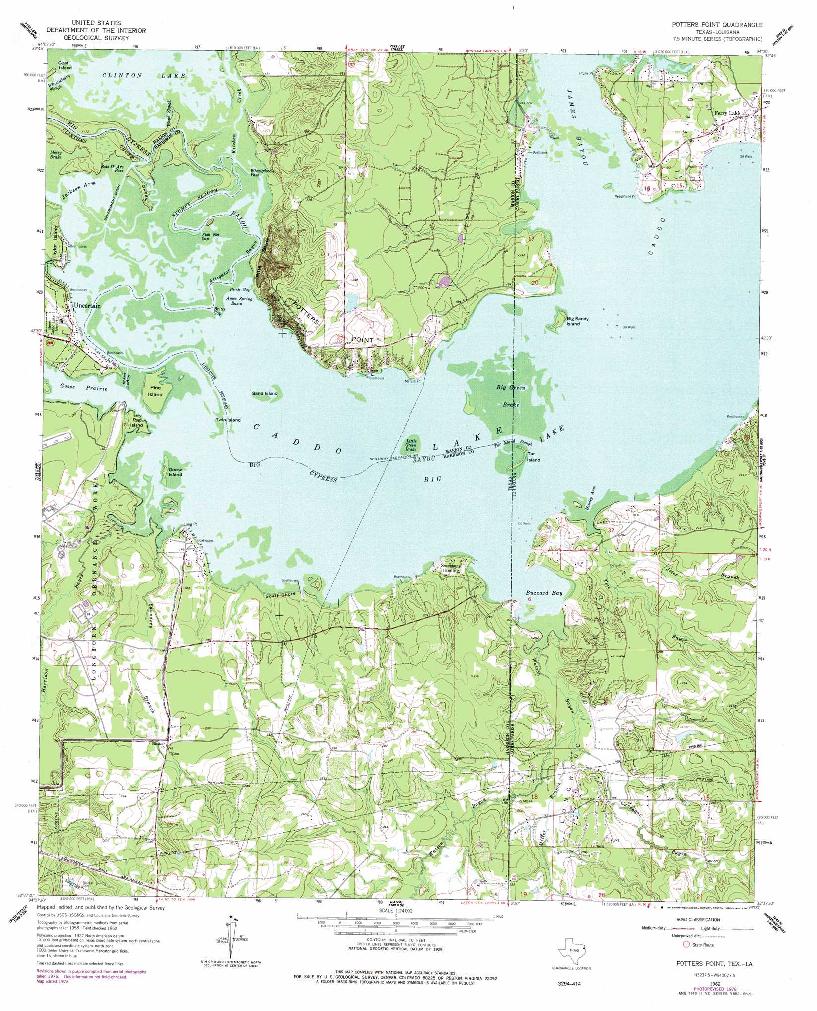
USGS Topo Quad 32094f1 - 1:24,000 scale
| Topo Map Name: | Potters Point |
| USGS Topo Quad ID: | 32094f1 |
| Print Size: | ca. 21 1/4" wide x 27" high |
| Southeast Coordinates: | 32.625° N latitude / 94° W longitude |
| Map Center Coordinates: | 32.6875° N latitude / 94.0625° W longitude |
| U.S. States: | TX, LA |
| Filename: | o32094f1.jpg |
| Download Map JPG Image: | Potters Point topo map 1:24,000 scale |
| Map Type: | Topographic |
| Topo Series: | 7.5´ |
| Map Scale: | 1:24,000 |
| Source of Map Images: | United States Geological Survey (USGS) |
| Alternate Map Versions: |
Potters Point TX 1962, updated 1964 Download PDF Buy paper map Potters Point TX 1962, updated 1977 Download PDF Buy paper map Potters Point TX 1962, updated 1978 Download PDF Buy paper map Potters Point TX 2010 Download PDF Buy paper map Potters Point TX 2013 Download PDF Buy paper map Potters Point TX 2016 Download PDF Buy paper map |
1:24,000 Topo Quads surrounding Potters Point
Lanier |
Kildare |
Mcleod |
Vivian North |
Wardview |
Jefferson |
Smithland |
Trees |
Vivian South |
Gilliam |
Woodlawn |
Karnack |
Potters Point |
Mooringsport |
Dixie |
Marshall East |
Scottsville |
Latex |
Blanchard |
North Highlands |
Colliers Creek |
Stricklin Springs |
Waskom |
Greenwood |
Shreveport West |
> Back to 32094e1 at 1:100,000 scale
> Back to 32094a1 at 1:250,000 scale
> Back to U.S. Topo Maps home
Potters Point topo map: Gazetteer
Potters Point: Airports
Fly-N-Fish Lodge Airport elevation 56m 183′Potters Point: Basins
Ames Spring Basin elevation 51m 167′Potters Point: Bays
Buzzard Bay elevation 51m 167′Goose Prairie elevation 51m 167′
Hawley Arm elevation 51m 167′
Jackson Arm elevation 51m 167′
Potters Point: Canals
Government Ditch elevation 51m 167′Starr Ditch elevation 51m 167′
Potters Point: Capes
Long Point elevation 51m 167′Millers Point elevation 51m 167′
Plum Point elevation 52m 170′
Westfield Point elevation 53m 173′
Potters Point: Cliffs
Pine Bluff elevation 68m 223′Potters Point elevation 75m 246′
Potters Point: Guts
Alligator Bayou elevation 51m 167′Blind Slough elevation 51m 167′
Britts Gap elevation 51m 167′
Clintons Chute elevation 51m 167′
Fish Net Gap elevation 51m 167′
Perch Gap elevation 51m 167′
Stumpy Slough elevation 51m 167′
Tar Island Slough elevation 51m 167′
Tar Island Slough elevation 51m 167′
Whangdoodle Pass elevation 51m 167′
Potters Point: Islands
Big Green Break elevation 51m 167′Big Sandy Island elevation 51m 167′
Goose Island elevation 52m 170′
Pine Island elevation 54m 177′
Rag Island elevation 52m 170′
Sand Island elevation 51m 167′
Tar Island elevation 51m 167′
Taylor Island elevation 52m 170′
Twin Island elevation 51m 167′
Potters Point: Lakes
Big Lake elevation 51m 167′Clinton Lake elevation 51m 167′
Potters Point: Oilfields
Caddo Oil Field elevation 54m 177′Longwood Oil Field elevation 53m 173′
Potters Point: Populated Places
Ferry Lake elevation 59m 193′South Shore elevation 52m 170′
Swansons Landing elevation 52m 170′
Uncertain elevation 55m 180′
Potters Point: Streams
Big Cypress Bayou elevation 51m 167′Gardener Bayou elevation 54m 177′
Harrison Bayou elevation 51m 167′
James Bayou elevation 51m 167′
Jeter Branch elevation 53m 173′
Kitchen Creek elevation 51m 167′
Miller Branch elevation 54m 177′
Saunders Branch elevation 51m 167′
Tete Bayou elevation 51m 167′
Watson Bayou elevation 51m 167′
Watson Bayou elevation 52m 170′
Potters Point: Swamps
Big Green Break elevation 51m 167′Little Green Brake elevation 51m 167′
Mossy Brake elevation 51m 167′
Potters Point digital topo map on disk
Buy this Potters Point topo map showing relief, roads, GPS coordinates and other geographical features, as a high-resolution digital map file on DVD: