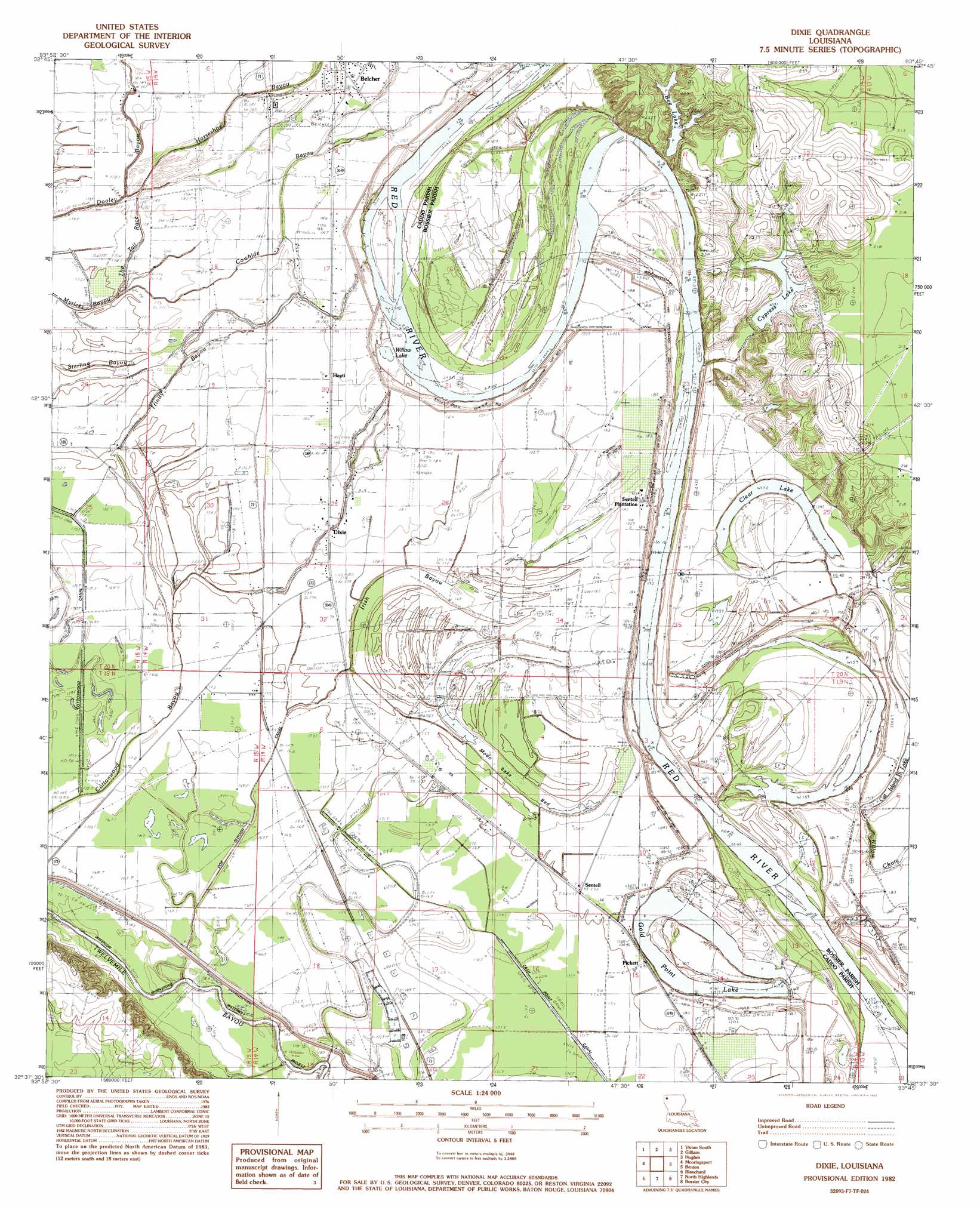
Dixie Topo Map Louisiana
To zoom in, hover over the map of Dixie
USGS Topo Quad 32093f7 - 1:24,000 scale
| Topo Map Name: | Dixie |
| USGS Topo Quad ID: | 32093f7 |
| Print Size: | ca. 21 1/4" wide x 27" high |
| Southeast Coordinates: | 32.625° N latitude / 93.75° W longitude |
| Map Center Coordinates: | 32.6875° N latitude / 93.8125° W longitude |
| U.S. State: | LA |
| Filename: | o32093f7.jpg |
| Download Map JPG Image: | Dixie topo map 1:24,000 scale |
| Map Type: | Topographic |
| Topo Series: | 7.5´ |
| Map Scale: | 1:24,000 |
| Source of Map Images: | United States Geological Survey (USGS) |
| Alternate Map Versions: |
Dixie LA 1982, updated 1982 Download PDF Buy paper map Dixie LA 2012 Download PDF Buy paper map Dixie LA 2015 Download PDF Buy paper map |
1:24,000 Topo Quads surrounding Dixie
Mcleod |
Vivian North |
Wardview |
Plain Dealing |
Carterville |
Trees |
Vivian South |
Gilliam |
Hughes |
Ivan |
Potters Point |
Mooringsport |
Dixie |
Benton |
Bodcau Lake |
Latex |
Blanchard |
North Highlands |
Bossier City |
Eastwood |
Waskom |
Greenwood |
Shreveport West |
Shreveport East |
Sligo |
> Back to 32093e1 at 1:100,000 scale
> Back to 32092a1 at 1:250,000 scale
> Back to U.S. Topo Maps home
Dixie topo map: Gazetteer
Dixie: Airports
Dixie Airstrip elevation 56m 183′Dixie: Areas
Caddo Prairie elevation 53m 173′Dixie: Canals
Cash Point Canal elevation 52m 170′Cottonwood Canal elevation 51m 167′
Doe Slough Canal elevation 52m 170′
Jefferson Shreveport Waterway Project elevation 47m 154′
Dixie: Cliffs
Hurrican Bluffs elevation 51m 167′Dixie: Crossings
Brier Field Ferry (historical) elevation 51m 167′Sentell Ferry (historical) elevation 47m 154′
Dixie: Dams
Bee Lake Dam elevation 49m 160′Dixie: Flats
Moon Lake Bed elevation 50m 164′Dixie: Guts
Dooley Bayou elevation 55m 180′The Trail Race elevation 54m 177′
Trinity Bayou elevation 54m 177′
Dixie: Lakes
Bee Lake elevation 57m 187′Clear Lake elevation 53m 173′
Cottonwood Lake (historical) elevation 52m 170′
Gold Point Lake elevation 48m 157′
Moon Lake (historical) elevation 50m 164′
Stumpy Lake (historical) elevation 50m 164′
Williams Lake (historical) elevation 50m 164′
Willow Lake elevation 51m 167′
Dixie: Oilfields
Dixie Oil Field elevation 52m 170′Rock Point Oil Field elevation 54m 177′
Dixie: Populated Places
Belcher elevation 56m 183′Dixie elevation 55m 180′
Hayti elevation 56m 183′
Pickett elevation 55m 180′
Sentell elevation 53m 173′
Uni (historical) elevation 57m 187′
Dixie: Reservoirs
Cypress Lake elevation 58m 190′Dixie: Streams
Cowhide Bayou elevation 53m 173′Horseshoe Bayou elevation 54m 177′
Irish Bayou elevation 52m 170′
Sullivan Slough elevation 46m 150′
Thompson Bayou elevation 54m 177′
Willow Chute elevation 52m 170′
Dixie digital topo map on disk
Buy this Dixie topo map showing relief, roads, GPS coordinates and other geographical features, as a high-resolution digital map file on DVD: