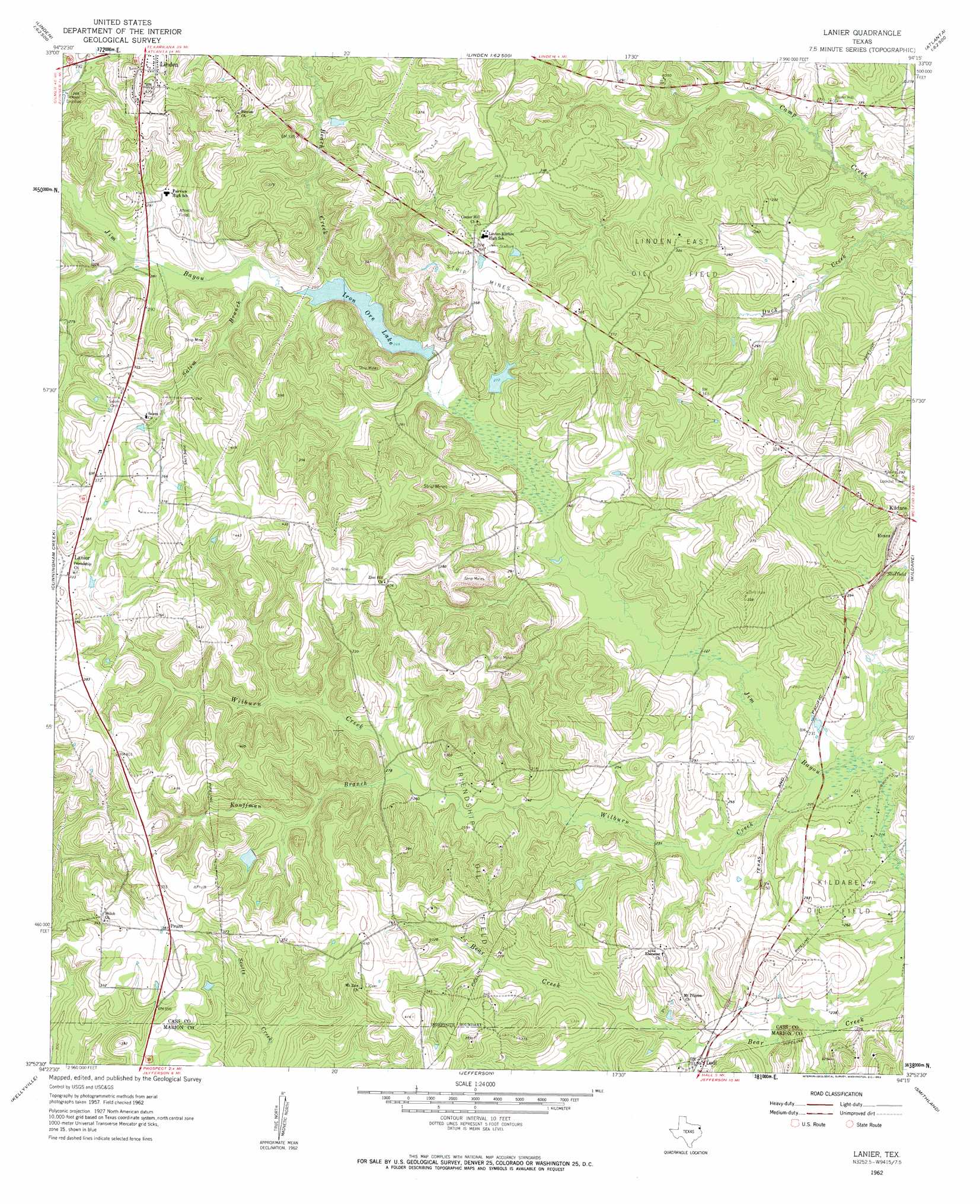
Lanier Topo Map Texas
To zoom in, hover over the map of Lanier
USGS Topo Quad 32094h3 - 1:24,000 scale
| Topo Map Name: | Lanier |
| USGS Topo Quad ID: | 32094h3 |
| Print Size: | ca. 21 1/4" wide x 27" high |
| Southeast Coordinates: | 32.875° N latitude / 94.25° W longitude |
| Map Center Coordinates: | 32.9375° N latitude / 94.3125° W longitude |
| U.S. State: | TX |
| Filename: | o32094h3.jpg |
| Download Map JPG Image: | Lanier topo map 1:24,000 scale |
| Map Type: | Topographic |
| Topo Series: | 7.5´ |
| Map Scale: | 1:24,000 |
| Source of Map Images: | United States Geological Survey (USGS) |
| Alternate Map Versions: |
Lanier TX 1962, updated 1963 Download PDF Buy paper map Lanier TX 2010 Download PDF Buy paper map Lanier TX 2013 Download PDF Buy paper map Lanier TX 2016 Download PDF Buy paper map |
1:24,000 Topo Quads surrounding Lanier
Marietta |
Bryans Mill |
Douglassville |
Atlanta North |
Bloomburg |
Sardis |
Carterville |
Linden |
Atlanta South |
Ravanna |
Avinger |
Cunningham Creek |
Lanier |
Kildare |
Mcleod |
Lassater |
Kellyville |
Jefferson |
Smithland |
Trees |
Harleton |
Marshall Nw |
Woodlawn |
Karnack |
Potters Point |
> Back to 32094e1 at 1:100,000 scale
> Back to 32094a1 at 1:250,000 scale
> Back to U.S. Topo Maps home
Lanier topo map: Gazetteer
Lanier: Dams
Hall Lake Number 1 Dam elevation 83m 272′Hall Lake Number 2 Dam elevation 80m 262′
Iron Ore Lake Dam elevation 76m 249′
Lanier: Oilfields
Friendship Oil Field elevation 98m 321′Linden East Oil Field elevation 101m 331′
Lanier: Populated Places
Evans elevation 88m 288′Lanier elevation 103m 337′
Lodi elevation 77m 252′
Pruett elevation 116m 380′
Sheffield elevation 76m 249′
Lanier: Reservoirs
Hall Lake Number 1 elevation 83m 272′Hall Lake Number 2 elevation 80m 262′
Iron Ore Lake elevation 77m 252′
Lanier: Streams
Beach Creek elevation 76m 249′Kouffman Branch elevation 77m 252′
Salem Branch elevation 77m 252′
Wilburn Creek elevation 66m 216′
Lanier digital topo map on disk
Buy this Lanier topo map showing relief, roads, GPS coordinates and other geographical features, as a high-resolution digital map file on DVD: