Hephzibah Topo Map Georgia
To zoom in, hover over the map of Hephzibah
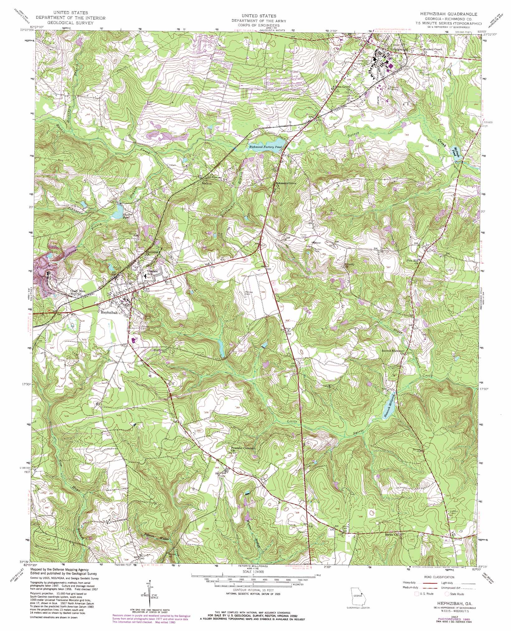
USGS Topo Quad 33082c1 - 1:24,000 scale
| Topo Map Name: | Hephzibah |
| USGS Topo Quad ID: | 33082c1 |
| Print Size: | ca. 21 1/4" wide x 27" high |
| Southeast Coordinates: | 33.25° N latitude / 82° W longitude |
| Map Center Coordinates: | 33.3125° N latitude / 82.0625° W longitude |
| U.S. State: | GA |
| Filename: | o33082c1.jpg |
| Download Map JPG Image: | Hephzibah topo map 1:24,000 scale |
| Map Type: | Topographic |
| Topo Series: | 7.5´ |
| Map Scale: | 1:24,000 |
| Source of Map Images: | United States Geological Survey (USGS) |
| Alternate Map Versions: |
Hephzibah GA 1950 Download PDF Buy paper map Hephzibah GA 1957, updated 1960 Download PDF Buy paper map Hephzibah GA 1957, updated 1973 Download PDF Buy paper map Hephzibah GA 1957, updated 1981 Download PDF Buy paper map Hephzibah GA 2011 Download PDF Buy paper map Hephzibah GA 2014 Download PDF Buy paper map |
1:24,000 Topo Quads surrounding Hephzibah
Appling |
Evans |
Martinez |
North Augusta |
Graniteville |
Harlem |
Grovetown |
Augusta West |
Augusta East |
Hollow Creek |
Avondale |
Blythe |
Hephzibah |
Mechanic Hill |
Jackson |
Matthews |
Keysville |
Storys Millpond |
Mcbean |
Shell Bluff Landing |
Kellys Pond |
Gough |
Waynesboro |
Idlewood |
Alexander |
> Back to 33082a1 at 1:100,000 scale
> Back to 33082a1 at 1:250,000 scale
> Back to U.S. Topo Maps home
Hephzibah topo map: Gazetteer
Hephzibah: Dams
Babcock Wilcox Lake Dam elevation 80m 262′Carrolls Lake Dam elevation 119m 390′
Hancock Millpond Dam elevation 53m 173′
Rhodes Pond Dam elevation 68m 223′
Richmond Factory Pond Dam elevation 56m 183′
Hephzibah: Populated Places
DeBruce elevation 61m 200′Gracewood elevation 98m 321′
Hephzibah elevation 122m 400′
Melton elevation 78m 255′
Rain Tree elevation 128m 419′
Town and Country elevation 130m 426′
Hephzibah: Reservoirs
Babcock Wilcox Lake elevation 80m 262′Carrolls Lake elevation 119m 390′
Hancock Millpond elevation 53m 173′
McDade Pond elevation 47m 154′
Rhodes Pond elevation 68m 223′
Richmond Factory Pond elevation 54m 177′
Hephzibah: Streams
Boggy Branch elevation 48m 157′Bowlmaker Branch elevation 57m 187′
Grindstone Branch elevation 69m 226′
Horsepen Branch elevation 64m 209′
Johnsons Branch elevation 61m 200′
Hephzibah digital topo map on disk
Buy this Hephzibah topo map showing relief, roads, GPS coordinates and other geographical features, as a high-resolution digital map file on DVD:
South Carolina, Western North Carolina & Northeastern Georgia
Buy digital topo maps: South Carolina, Western North Carolina & Northeastern Georgia