Harlem Topo Map Georgia
To zoom in, hover over the map of Harlem
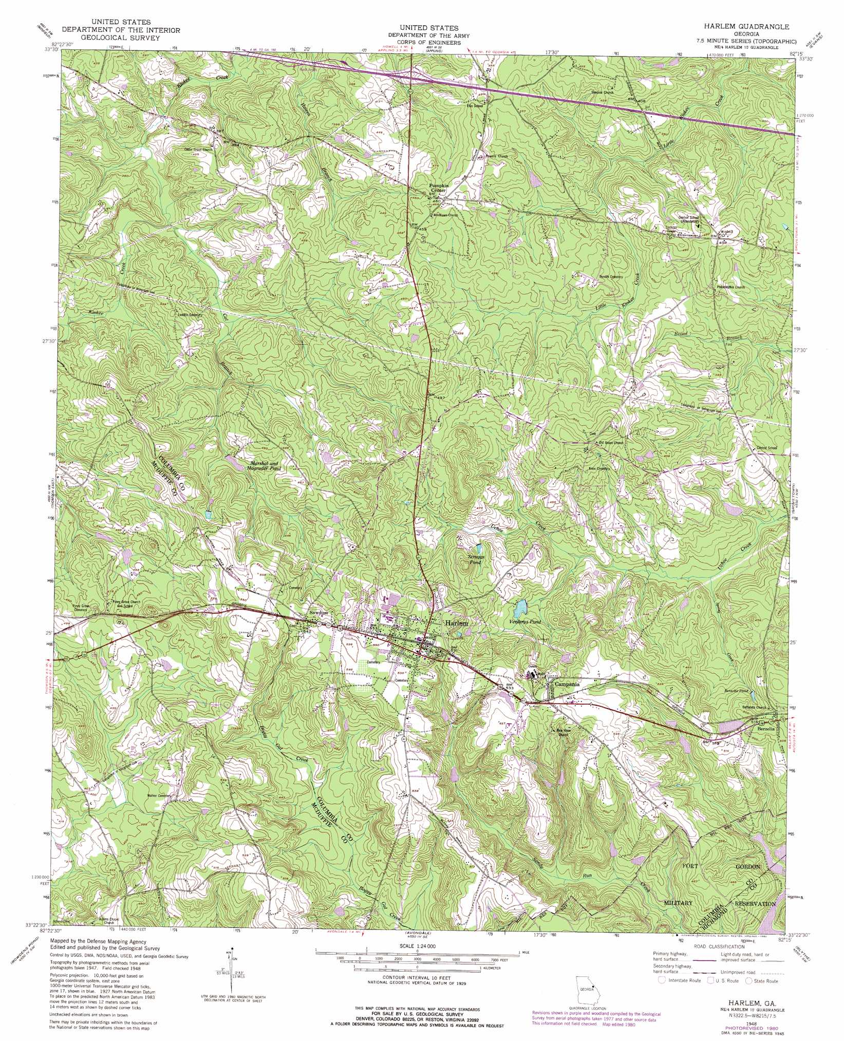
USGS Topo Quad 33082d3 - 1:24,000 scale
| Topo Map Name: | Harlem |
| USGS Topo Quad ID: | 33082d3 |
| Print Size: | ca. 21 1/4" wide x 27" high |
| Southeast Coordinates: | 33.375° N latitude / 82.25° W longitude |
| Map Center Coordinates: | 33.4375° N latitude / 82.3125° W longitude |
| U.S. State: | GA |
| Filename: | o33082d3.jpg |
| Download Map JPG Image: | Harlem topo map 1:24,000 scale |
| Map Type: | Topographic |
| Topo Series: | 7.5´ |
| Map Scale: | 1:24,000 |
| Source of Map Images: | United States Geological Survey (USGS) |
| Alternate Map Versions: |
Harlem GA 1948, updated 1969 Download PDF Buy paper map Harlem GA 1948, updated 1980 Download PDF Buy paper map Harlem GA 1950 Download PDF Buy paper map Harlem GA 2011 Download PDF Buy paper map Harlem GA 2014 Download PDF Buy paper map |
1:24,000 Topo Quads surrounding Harlem
Aonia |
Woodlawn |
Leah |
Clarks Hill |
Colliers |
Wrightsboro |
Winfield |
Appling |
Evans |
Martinez |
Thomson West |
Thompson East |
Harlem |
Grovetown |
Augusta West |
Bastonville |
Bowdens Pond |
Avondale |
Blythe |
Hephzibah |
Gibson |
Wrens |
Matthews |
Keysville |
Storys Millpond |
> Back to 33082a1 at 1:100,000 scale
> Back to 33082a1 at 1:250,000 scale
> Back to U.S. Topo Maps home
Harlem topo map: Gazetteer
Harlem: Crossings
Exit 61 elevation 113m 370′Harlem: Dams
Hill Lake Dam elevation 120m 393′Morris Lake Dam elevation 125m 410′
Verderys Pond Dam elevation 122m 400′
Harlem: Populated Places
Adamsville elevation 136m 446′Berzelia elevation 150m 492′
Campania elevation 161m 528′
Harlem elevation 163m 534′
Sawdust elevation 165m 541′
Harlem: Reservoirs
Berzelia Pond elevation 136m 446′Hill Lake elevation 120m 393′
Marshal and Magruder Pond elevation 116m 380′
Morris Lake elevation 125m 410′
Scruggs Pond elevation 127m 416′
Verderys Pond elevation 122m 400′
Harlem: Streams
Allen Branch elevation 102m 334′Cat Branch elevation 97m 318′
Spring Creek elevation 102m 334′
Harlem digital topo map on disk
Buy this Harlem topo map showing relief, roads, GPS coordinates and other geographical features, as a high-resolution digital map file on DVD:
South Carolina, Western North Carolina & Northeastern Georgia
Buy digital topo maps: South Carolina, Western North Carolina & Northeastern Georgia