Sugarloaf Peak Topo Map New Mexico
To zoom in, hover over the map of Sugarloaf Peak
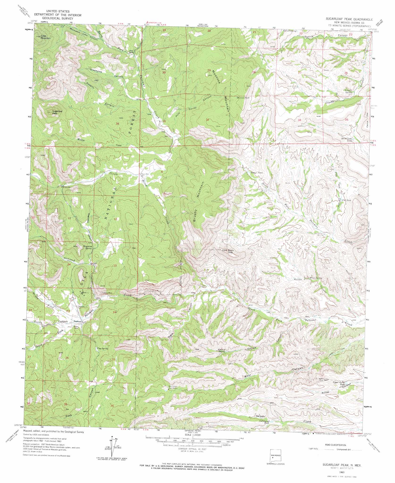
USGS Topo Quad 33107b6 - 1:24,000 scale
| Topo Map Name: | Sugarloaf Peak |
| USGS Topo Quad ID: | 33107b6 |
| Print Size: | ca. 21 1/4" wide x 27" high |
| Southeast Coordinates: | 33.125° N latitude / 107.625° W longitude |
| Map Center Coordinates: | 33.1875° N latitude / 107.6875° W longitude |
| U.S. State: | NM |
| Filename: | o33107b6.jpg |
| Download Map JPG Image: | Sugarloaf Peak topo map 1:24,000 scale |
| Map Type: | Topographic |
| Topo Series: | 7.5´ |
| Map Scale: | 1:24,000 |
| Source of Map Images: | United States Geological Survey (USGS) |
| Alternate Map Versions: |
Sugarloaf Peak NM 1963, updated 1965 Download PDF Buy paper map Sugarloaf Peak NM 1999, updated 2002 Download PDF Buy paper map Sugarloaf Peak NM 2011 Download PDF Buy paper map Sugarloaf Peak NM 2013 Download PDF Buy paper map Sugarloaf Peak NM 2017 Download PDF Buy paper map |
| FStopo: | US Forest Service topo Sugarloaf Peak is available: Download FStopo PDF Download FStopo TIF |
1:24,000 Topo Quads surrounding Sugarloaf Peak
Taylor Peak |
Sawmill Peak |
Iron Mountain |
Jaralosa Mountain |
Monticello |
Baily Points |
Lookout Mountain |
Winston |
Chise |
Priest Tank |
Bonner Canyon |
Reeds Peak |
Sugarloaf Peak |
Thumb Tank Peak |
Williamsburg Nw |
Hay Mesa |
Victoria Park |
Apache Peak |
Bell Mountain |
Saladone Tank |
Hendricks Peak |
Hillsboro Peak |
Kingston |
Hillsboro |
Skute Stone Arroyo |
> Back to 33107a1 at 1:100,000 scale
> Back to 33106a1 at 1:250,000 scale
> Back to U.S. Topo Maps home
Sugarloaf Peak topo map: Gazetteer
Sugarloaf Peak: Mines
American Flag and Flagstaff Mine elevation 1917m 6289′Argonaut elevation 1856m 6089′
Cliff-L-Embolite elevation 1863m 6112′
Ocean Wave and Antelope elevation 1872m 6141′
Palomas Chief elevation 1854m 6082′
Pelican elevation 1875m 6151′
Pelican Group Mines elevation 1883m 6177′
Proctor Mine elevation 1938m 6358′
Protector Mine elevation 1936m 6351′
Wolford elevation 1915m 6282′
Sugarloaf Peak: Populated Places
Hermosa elevation 1862m 6108′Sugarloaf Peak: Post Offices
Hermosa Post Office (historical) elevation 1862m 6108′Sugarloaf Peak: Reservoirs
Bear Canyon Tank elevation 1976m 6482′Cottonwood Tank elevation 1932m 6338′
Flat Tank elevation 1821m 5974′
Lookout Tank elevation 2089m 6853′
Montosa Tank elevation 2130m 6988′
Rattlesnake Tank elevation 1873m 6145′
Romero Tank elevation 1829m 6000′
Upper Avilas Tank elevation 1890m 6200′
Sugarloaf Peak: Springs
Emrick Spring elevation 1886m 6187′Flag Spring elevation 1904m 6246′
Grapevine Spring elevation 1961m 6433′
Gurule Spring elevation 1913m 6276′
Poverty Spring elevation 1937m 6354′
Rouse Spring elevation 1765m 5790′
Sandstone Spring elevation 1962m 6437′
Sugarloaf Spring elevation 2012m 6601′
Trujillo Spring elevation 1875m 6151′
Wagonbed Spring elevation 1916m 6286′
Sugarloaf Peak: Streams
Circle Seven Creek elevation 1759m 5770′Morgan Creek elevation 1863m 6112′
Willow Creek elevation 1879m 6164′
Sugarloaf Peak: Summits
Black Peak elevation 2020m 6627′Brushy Mountain elevation 2242m 7355′
Cobb Mountain elevation 2367m 7765′
Montosa Mountain elevation 2167m 7109′
Sugarloaf Peak elevation 2293m 7522′
Sugarloaf Peak: Valleys
Curtis Canyon elevation 1864m 6115′Dark Canyon elevation 1770m 5807′
Emrick Canyon elevation 1722m 5649′
Flat Tank Canyon elevation 1778m 5833′
Grapevine Canyon elevation 1920m 6299′
Gurule Canyon elevation 1816m 5958′
Hickland Canyon elevation 1850m 6069′
Moccasin John Canyon elevation 1970m 6463′
Pole Corral Canyon elevation 1883m 6177′
Poverty Canyon elevation 1900m 6233′
Rouse Canyon elevation 1696m 5564′
Wagonbed Canyon elevation 1891m 6204′
Sugarloaf Peak: Wells
Circle Seven Well elevation 1765m 5790′Lower Coyote Well elevation 1838m 6030′
Middle Well elevation 1951m 6400′
Moccasin John Well elevation 2006m 6581′
Negro Bob Well elevation 1906m 6253′
Rouse Well elevation 1719m 5639′
Upper Coyote Well elevation 1930m 6332′
Upper House Well elevation 1947m 6387′
Sugarloaf Peak digital topo map on disk
Buy this Sugarloaf Peak topo map showing relief, roads, GPS coordinates and other geographical features, as a high-resolution digital map file on DVD: