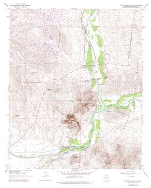
Granite Reef Dam Topo Map Arizona
To zoom in, hover over the map of Granite Reef Dam
USGS Topo Quad 33111e6 - 1:24,000 scale
| Topo Map Name: | Granite Reef Dam |
| USGS Topo Quad ID: | 33111e6 |
| Print Size: | ca. 21 1/4" wide x 27" high |
| Southeast Coordinates: | 33.5° N latitude / 111.625° W longitude |
| Map Center Coordinates: | 33.5625° N latitude / 111.6875° W longitude |
| U.S. State: | AZ |
| Filename: | o33111e6.jpg |
| Download Map JPG Image: | Granite Reef Dam topo map 1:24,000 scale |
| Map Type: | Topographic |
| Topo Series: | 7.5´ |
| Map Scale: | 1:24,000 |
| Source of Map Images: | United States Geological Survey (USGS) |
| Alternate Map Versions: |
Granite Reef Dam AZ 1964, updated 1965 Download PDF Buy paper map Granite Reef Dam AZ 1964, updated 1972 Download PDF Buy paper map Granite Reef Dam AZ 1964, updated 1977 Download PDF Buy paper map Granite Reef Dam AZ 1971, updated 1972 Download PDF Buy paper map Granite Reef Dam AZ 2004, updated 2007 Download PDF Buy paper map Granite Reef Dam AZ 2011 Download PDF Buy paper map Granite Reef Dam AZ 2014 Download PDF Buy paper map |
| FStopo: | US Forest Service topo Granite Reef Dam is available: Download FStopo PDF Download FStopo TIF |
1:24,000 Topo Quads surrounding Granite Reef Dam
> Back to 33111e1 at 1:100,000 scale
> Back to 33110a1 at 1:250,000 scale
> Back to U.S. Topo Maps home
Granite Reef Dam topo map: Gazetteer
Granite Reef Dam: Airports
Fountain Hills Airport elevation 403m 1322′Granite Reef Dam: Arroyos
Ashbrook Wash elevation 524m 1719′Colony Wash elevation 462m 1515′
Granite Reef Dam: Dams
Fountain Hills Dam elevation 476m 1561′Fountain Hills Dam Number Eleven elevation 526m 1725′
Fountain Hills Dam Number Four elevation 512m 1679′
Fountain Hills Dam Number Nineteen elevation 522m 1712′
Granite Reef Dam elevation 399m 1309′
Granite Reef Dam: Gaps
McDowell Pass elevation 479m 1571′Granite Reef Dam: Lakes
Fountain Lake elevation 481m 1578′Maxwell Lake (historical) elevation 406m 1332′
Granite Reef Dam: Parks
Camp Reno Historical Marker elevation 421m 1381′Fountain Park elevation 481m 1578′
Phon D Sutton Recreation Area elevation 407m 1335′
Granite Reef Dam: Populated Places
Fountain Hills elevation 489m 1604′Fountain View elevation 529m 1735′
Granite Reef Dam: Post Offices
Fountain Hills Post Office elevation 505m 1656′Granite Reef Dam: Reservoirs
McDowell Tank elevation 479m 1571′Granite Reef Dam: Streams
Verde River elevation 404m 1325′Granite Reef Dam: Summits
Apache Peak elevation 493m 1617′Arizona Dam Butte elevation 724m 2375′
Coon Bluff elevation 469m 1538′
Mount McDowell elevation 796m 2611′
Schlechts Butte elevation 537m 1761′
Usery Mountains elevation 886m 2906′
Granite Reef Dam digital topo map on disk
Buy this Granite Reef Dam topo map showing relief, roads, GPS coordinates and other geographical features, as a high-resolution digital map file on DVD:


