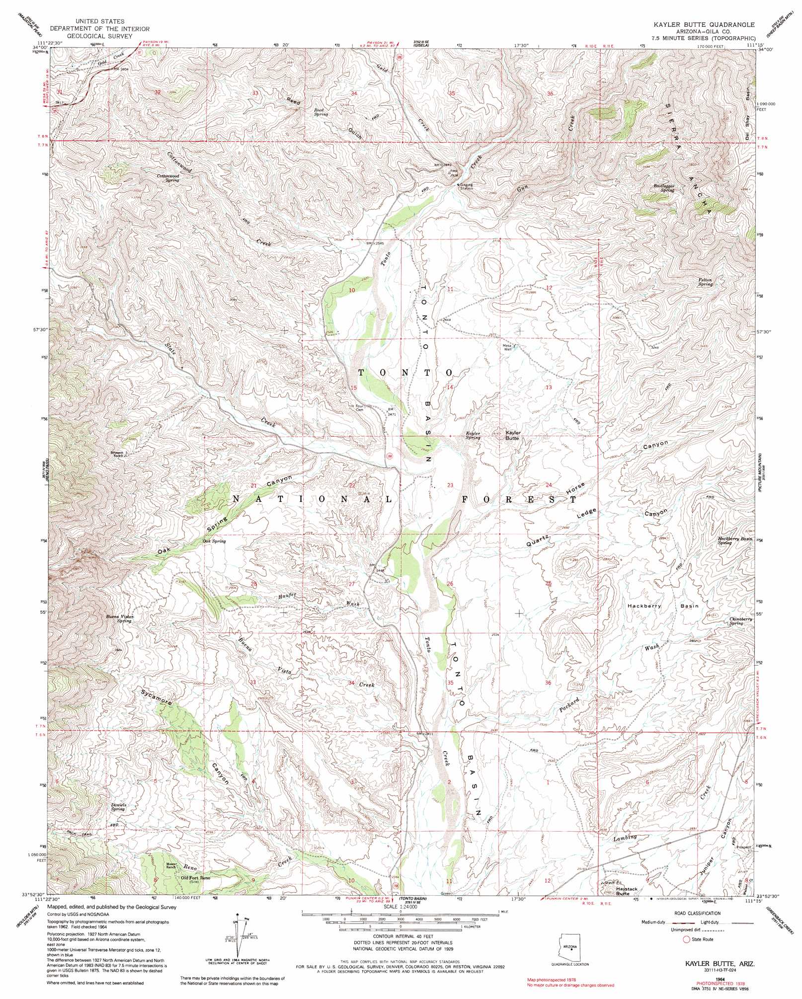
Kayler Butte Topo Map Arizona
To zoom in, hover over the map of Kayler Butte
USGS Topo Quad 33111h3 - 1:24,000 scale
| Topo Map Name: | Kayler Butte |
| USGS Topo Quad ID: | 33111h3 |
| Print Size: | ca. 21 1/4" wide x 27" high |
| Southeast Coordinates: | 33.875° N latitude / 111.25° W longitude |
| Map Center Coordinates: | 33.9375° N latitude / 111.3125° W longitude |
| U.S. State: | AZ |
| Filename: | o33111h3.jpg |
| Download Map JPG Image: | Kayler Butte topo map 1:24,000 scale |
| Map Type: | Topographic |
| Topo Series: | 7.5´ |
| Map Scale: | 1:24,000 |
| Source of Map Images: | United States Geological Survey (USGS) |
| Alternate Map Versions: |
Kayler Butte AZ 1964, updated 1965 Download PDF Buy paper map Kayler Butte AZ 1964, updated 1973 Download PDF Buy paper map Kayler Butte AZ 1964, updated 1991 Download PDF Buy paper map Kayler Butte AZ 2004, updated 2006 Download PDF Buy paper map Kayler Butte AZ 2011 Download PDF Buy paper map Kayler Butte AZ 2014 Download PDF Buy paper map |
| FStopo: | US Forest Service topo Kayler Butte is available: Download FStopo PDF Download FStopo TIF |
1:24,000 Topo Quads surrounding Kayler Butte
Cypress Butte |
North Peak |
Payson South |
Mcdonald Mountain |
Diamond Butte |
Table Mountain |
Mazatzal Peak |
Gisela |
Sheep Basin Mountain |
Buzzard Roost Mesa |
Lion Mountain |
Reno Pass |
Kayler Butte |
Picture Mountain |
Copper Mountain |
Maverick Mountain |
Boulder Mountain |
Tonto Basin |
Greenback Creek |
Armer Mountain |
Adams Mesa |
Mine Mountain |
Four Peaks |
Theodore Roosevelt Dam |
Windy Hill |
> Back to 33111e1 at 1:100,000 scale
> Back to 33110a1 at 1:250,000 scale
> Back to U.S. Topo Maps home
Kayler Butte topo map: Gazetteer
Kayler Butte: Areas
Haufer Research Natural Area elevation 820m 2690′Kayler Butte: Basins
Hackberry Basin elevation 844m 2769′Tonto Basin elevation 736m 2414′
Kayler Butte: Reservoirs
Gold Creek Tank elevation 1100m 3608′Gun Tank elevation 1009m 3310′
H Four Tank elevation 828m 2716′
Haystack Tank elevation 815m 2673′
Mesa Tank elevation 849m 2785′
Midway Tank elevation 932m 3057′
Quartz Ledge Tank elevation 853m 2798′
Sheep Tank elevation 793m 2601′
Kayler Butte: Springs
Ash Spring elevation 1333m 4373′Bootlegger Spring elevation 1125m 3690′
Buena Vista Spring elevation 817m 2680′
Buena Vista Spring elevation 1034m 3392′
Chinaberry Spring elevation 866m 2841′
Cottonwood Spring elevation 938m 3077′
Daniels Spring elevation 934m 3064′
Dipper Spring elevation 988m 3241′
Felton Spring elevation 1072m 3517′
Hackberry Basin Spring elevation 892m 2926′
Haufner Spring elevation 1208m 3963′
Kayler Spring elevation 749m 2457′
Oak Spring elevation 914m 2998′
Oak Spring elevation 872m 2860′
Point of Rock Spring elevation 901m 2956′
Reed Spring elevation 869m 2851′
Water Wheel Spring elevation 1034m 3392′
Kayler Butte: Streams
Buena Vista Creek elevation 718m 2355′Cottonwood Creek elevation 768m 2519′
Gold Creek elevation 772m 2532′
Gun Creek elevation 767m 2516′
Hardt Creek elevation 789m 2588′
Haufer Wash elevation 726m 2381′
Packard Wash elevation 719m 2358′
Slate Creek elevation 742m 2434′
Kayler Butte: Summits
Haystack Butte elevation 839m 2752′Kayler Butte elevation 880m 2887′
Kayler Butte: Valleys
Horse Canyon elevation 742m 2434′Oak Spring Canyon elevation 764m 2506′
Quartz Ledge Canyon elevation 737m 2417′
Reed Gulch elevation 781m 2562′
Sycamore Canyon elevation 743m 2437′
Kayler Butte: Wells
Mesa Well elevation 827m 2713′Kayler Butte digital topo map on disk
Buy this Kayler Butte topo map showing relief, roads, GPS coordinates and other geographical features, as a high-resolution digital map file on DVD: