Phoenix Topo Map Arizona
To zoom in, hover over the map of Phoenix
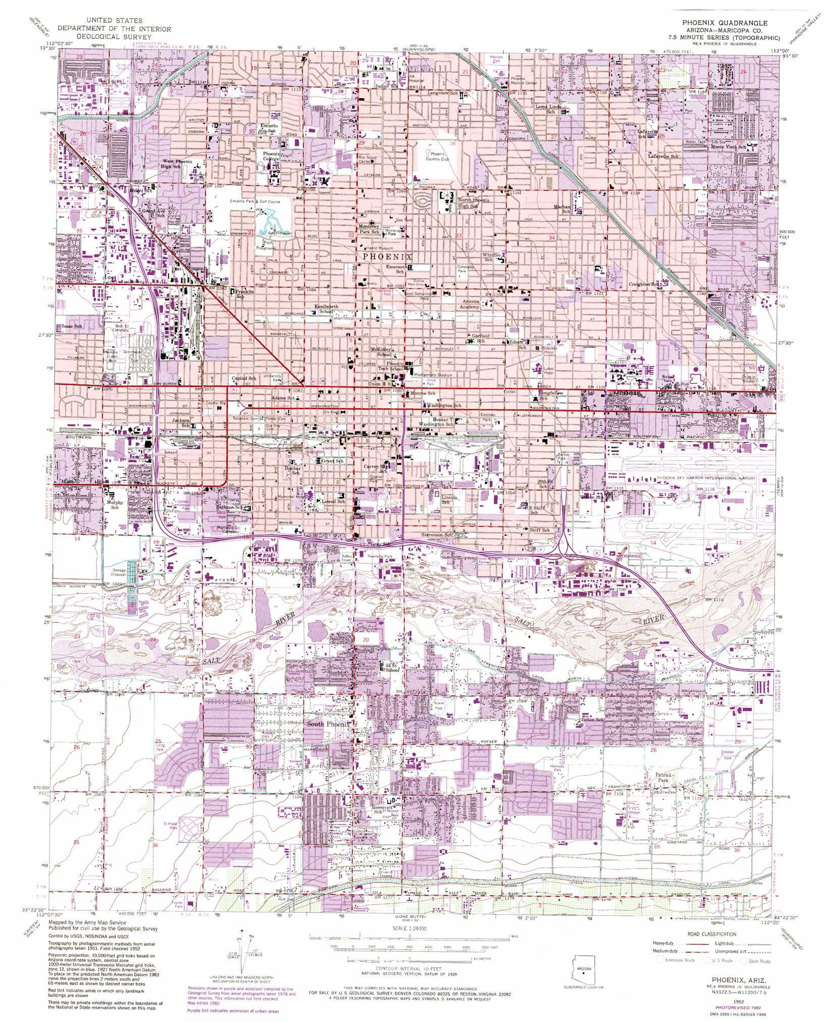
USGS Topo Quad 33112d1 - 1:24,000 scale
| Topo Map Name: | Phoenix |
| USGS Topo Quad ID: | 33112d1 |
| Print Size: | ca. 21 1/4" wide x 27" high |
| Southeast Coordinates: | 33.375° N latitude / 112° W longitude |
| Map Center Coordinates: | 33.4375° N latitude / 112.0625° W longitude |
| U.S. State: | AZ |
| Filename: | o33112d1.jpg |
| Download Map JPG Image: | Phoenix topo map 1:24,000 scale |
| Map Type: | Topographic |
| Topo Series: | 7.5´ |
| Map Scale: | 1:24,000 |
| Source of Map Images: | United States Geological Survey (USGS) |
| Alternate Map Versions: |
Phoenix AZ 1952, updated 1957 Download PDF Buy paper map Phoenix AZ 1952, updated 1968 Download PDF Buy paper map Phoenix AZ 1952, updated 1975 Download PDF Buy paper map Phoenix AZ 1952, updated 1983 Download PDF Buy paper map Phoenix AZ 1952, updated 1983 Download PDF Buy paper map Phoenix AZ 1971, updated 1972 Download PDF Buy paper map Phoenix AZ 2011 Download PDF Buy paper map Phoenix AZ 2014 Download PDF Buy paper map |
1:24,000 Topo Quads surrounding Phoenix
Calderwood Butte |
Hedgpeth Hills |
Union Hills |
Currys Corner |
Mcdowell Peak |
El Mirage |
Glendale |
Sunnyslope |
Paradise Valley |
Sawik Mountain |
Tolleson |
Fowler |
Phoenix |
Tempe |
Mesa |
Avondale Se |
Laveen |
Lone Butte |
Guadalupe |
Chandler |
Mobile Ne |
Montezuma Peak |
Pima Butte |
Gila Butte Nw |
Gila Butte |
> Back to 33112a1 at 1:100,000 scale
> Back to 33112a1 at 1:250,000 scale
> Back to U.S. Topo Maps home
Phoenix topo map: Gazetteer
Phoenix: Airports
Abacus Tower Heliport elevation 335m 1099′Burns International Incorporated Heliport elevation 341m 1118′
Good Samaritan Hospital Heliport elevation 334m 1095′
Good Samaritan Medical Center Heliport elevation 334m 1095′
Knoell-Main Office Heliport elevation 336m 1102′
KOOL Heliport elevation 330m 1082′
KPNX TV Studio Heliport elevation 331m 1085′
KPNX-TV Studios Heliport elevation 331m 1085′
KTSP Heliport elevation 330m 1082′
Maricopa General Hospital Heliport elevation 339m 1112′
Maricopa Medical Center Heliport elevation 339m 1112′
Memorial Hospital Heliport elevation 326m 1069′
Phoenix Memorial Hospital Heliport elevation 326m 1069′
Phoenix Sky Harbor International Airport elevation 342m 1122′
Police and Public Safety Building Heliport elevation 330m 1082′
Saguaro Airport elevation 340m 1115′
Saint Josephs Hospital Heliport elevation 335m 1099′
Saint Josephs Hospital Helistop elevation 335m 1099′
United Bank Plaza Heliport elevation 336m 1102′
Phoenix: Canals
Canal Bueno Lower Branch (historical) elevation 338m 1108′Canal Ciudad (historical) elevation 338m 1108′
Canal Five Lower Branch (historical) elevation 328m 1076′
Canal Four (historical) elevation 342m 1122′
Canal Patrick (historical) elevation 335m 1099′
Canal Patrick Lower Branch (historical) elevation 332m 1089′
Canal Seven (historical) elevation 337m 1105′
Canal Seven Lower Branch (historical) elevation 339m 1112′
Canal Ten (historical) elevation 337m 1105′
Canal Turney (historical) elevation 334m 1095′
Canal Viejo Central Branch (historical) elevation 338m 1108′
La Toma Crosscut Canal (historical) elevation 342m 1122′
Marmonier Ditch elevation 331m 1085′
San Francisco Canal North Branch elevation 0m 0′
San Francisco Canal South Branch elevation 0m 0′
Western Canal elevation 358m 1174′
Phoenix: Crossings
Interchange 142 elevation 329m 1079′Interchange 143A elevation 329m 1079′
Interchange 143B elevation 329m 1079′
Interchange 143C elevation 330m 1082′
Interchange 144A elevation 331m 1085′
Interchange 144B elevation 331m 1085′
Interchange 145 elevation 333m 1092′
Interchange 146 elevation 336m 1102′
Interchange 147A elevation 340m 1115′
Interchange 147B elevation 339m 1112′
Interchange 148 elevation 336m 1102′
Interchange 149 elevation 336m 1102′
Interchange One Hundred Fifty elevation 337m 1105′
Phoenix: Lakes
Encanto Lagoon elevation 333m 1092′Phoenix: Parks
Aholi Park elevation 334m 1095′Alkire Park elevation 323m 1059′
America West Arena elevation 331m 1085′
Aya Park elevation 336m 1102′
Berney Park elevation 336m 1102′
Central Park elevation 329m 1079′
Chase Field elevation 331m 1085′
Chiwap Park elevation 334m 1095′
Coffelt Lamoreaux Park elevation 323m 1059′
Coronado Park elevation 335m 1099′
Eastlake Park elevation 333m 1092′
Edison Park elevation 337m 1105′
El Prado Park elevation 335m 1099′
El Reposa Park elevation 343m 1125′
Encanto Park elevation 334m 1095′
Esteban Park elevation 344m 1128′
Florence Crittenden Home elevation 333m 1092′
Grant Park elevation 328m 1076′
Green Valley Park elevation 330m 1082′
Harmon Park elevation 327m 1072′
Hayden Park elevation 327m 1072′
Heritage Square elevation 332m 1089′
Hermoso Park elevation 342m 1122′
Hochani Park elevation 336m 1102′
Ho-e Park elevation 326m 1069′
Ju Ot Te Park elevation 329m 1079′
Kana Park elevation 335m 1099′
Lenang Park elevation 338m 1108′
Lewis Park elevation 331m 1085′
Library Park elevation 330m 1082′
Lindo Park elevation 323m 1059′
Los Olivos Park elevation 359m 1177′
M O Best Park elevation 332m 1089′
Madison Park elevation 346m 1135′
Mathew Henson Park elevation 325m 1066′
Momo Park elevation 333m 1092′
Monterey Park elevation 334m 1095′
Montgomery Stadium elevation 333m 1092′
Niña-Niños elevation 325m 1066′
Nuestro Park elevation 331m 1085′
Nueve Park elevation 330m 1082′
Patriot Square elevation 331m 1085′
Perry Park elevation 353m 1158′
Rio Salado Industrial Recreation Park elevation 332m 1089′
Riverside Park elevation 329m 1079′
Roesley Park elevation 326m 1069′
Roosevelt Park elevation 331m 1085′
Sherman Parkway elevation 324m 1062′
Sohu Park elevation 336m 1102′
Stephen Park elevation 331m 1085′
Tocha Park elevation 324m 1062′
Townsend Park elevation 333m 1092′
Tuhavi Park elevation 341m 1118′
Tumas Park elevation 325m 1066′
University Park elevation 329m 1079′
Verde Park elevation 333m 1092′
Virginia Park elevation 339m 1112′
Willow Park elevation 340m 1115′
Willow Park elevation 327m 1072′
Woodland Parkway elevation 330m 1082′
Yapa Park elevation 339m 1112′
Yunya Park elevation 325m 1066′
Phoenix: Populated Places
A and F Trailer Park elevation 341m 1118′A-1 Trailer Park elevation 342m 1122′
Aristocrat Trailer Park elevation 340m 1115′
Bel-Aire Trailer Park elevation 338m 1108′
Blue Palm Mobile Home Park elevation 326m 1069′
Broadway Trailer Court elevation 321m 1053′
Bronze Boot elevation 343m 1125′
Cactus Cove Trailer Park elevation 327m 1072′
Camelback Trailer Ranch elevation 342m 1122′
Chapparal Mobile Village elevation 354m 1161′
Citrus Hills elevation 358m 1174′
Country Club Trailer Grove elevation 356m 1167′
Countryside Mobile Home Park elevation 341m 1118′
DeLuxe Trailer Court elevation 327m 1072′
El Sereno-La Rosa Trailer Inn elevation 342m 1122′
Estrella Estates Family Park elevation 332m 1089′
Grandview Mobile Home Park elevation 353m 1158′
Green Acres Mobile and Recreational Vehicle Park elevation 327m 1072′
Green Valley Trailer Park elevation 345m 1131′
Lazy D Trailer Ranch elevation 354m 1161′
McDowell Trailer Village elevation 349m 1145′
Palms Trailer Park elevation 340m 1115′
Patrick Park elevation 343m 1125′
Pecan Grove Trailer Park elevation 339m 1112′
Phoenix elevation 331m 1085′
Plaza Trailer Inn elevation 344m 1128′
Rancho Hermoso elevation 344m 1128′
Rancho Mobile Estates elevation 352m 1154′
Roadrunner Mobile Home Park elevation 329m 1079′
Sleepy Hollow Trailer Village elevation 331m 1085′
South Phoenix elevation 327m 1072′
Southern Acres Mobile Home Park elevation 346m 1135′
Squaw Peak Terrace elevation 360m 1181′
Sun Trailer Park elevation 327m 1072′
Sun Valley Trailer Park elevation 348m 1141′
Thomas Trailer Court elevation 343m 1125′
Trail Inn Lodge elevation 326m 1069′
Valley Gardens Trailer Park elevation 344m 1128′
Villa Monte Vista elevation 339m 1112′
Washington Trailer Park elevation 343m 1125′
Wigwam Villa Mobile Home Park elevation 332m 1089′
Phoenix: Post Offices
Capitol Station Post Office elevation 327m 1072′Downtown Phoenix Post Office elevation 331m 1085′
Downtown Station Post Office elevation 331m 1085′
McDowell Post Office elevation 344m 1128′
McDowell Station Post Office elevation 344m 1128′
Northeast Station Post Office elevation 352m 1154′
Osborn Post Office elevation 339m 1112′
Rio Salado Post Office elevation 333m 1092′
South Central Post Office elevation 340m 1115′
Southeast Station Post Office elevation 333m 1092′
Phoenix digital topo map on disk
Buy this Phoenix topo map showing relief, roads, GPS coordinates and other geographical features, as a high-resolution digital map file on DVD: