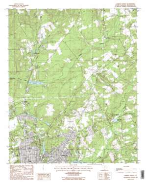
Camden North Topo Map South Carolina
To zoom in, hover over the map of Camden North
USGS Topo Quad 34080c5 - 1:24,000 scale
| Topo Map Name: | Camden North |
| USGS Topo Quad ID: | 34080c5 |
| Print Size: | ca. 21 1/4" wide x 27" high |
| Southeast Coordinates: | 34.25° N latitude / 80.5° W longitude |
| Map Center Coordinates: | 34.3125° N latitude / 80.5625° W longitude |
| U.S. State: | SC |
| Filename: | o34080c5.jpg |
| Download Map JPG Image: | Camden North topo map 1:24,000 scale |
| Map Type: | Topographic |
| Topo Series: | 7.5´ |
| Map Scale: | 1:24,000 |
| Source of Map Images: | United States Geological Survey (USGS) |
| Alternate Map Versions: |
Camden North SC 1988, updated 1988 Download PDF Buy paper map Camden North SC 1988, updated 1988 Download PDF Buy paper map Camden North SC 2011 Download PDF Buy paper map Camden North SC 2014 Download PDF Buy paper map |
1:24,000 Topo Quads surrounding Camden North
> Back to 34080a1 at 1:100,000 scale
> Back to 34080a1 at 1:250,000 scale
> Back to U.S. Topo Maps home
Camden North topo map: Gazetteer
Camden North: Airports
Woodward Field elevation 91m 298′Camden North: Dams
Kendall Lake Dam elevation 50m 164′Sinclair Pond Dam D-1328 elevation 58m 190′
South Carolina Noname 28002 D-1329 Dam elevation 66m 216′
South Carolina Noname 28003 D-2502 Dam elevation 73m 239′
South Carolina Noname 28017 D-2501 Dam elevation 77m 252′
South Carolina Noname 28026 D-1322 Dam elevation 60m 196′
South Carolina Noname 28028 D-2527 Dam elevation 69m 226′
South Carolina Noname 28047 D-2528 Dam elevation 68m 223′
Sunny Hill Pond Dam Number One D-2523 elevation 79m 259′
Tidwells Pond Dam D-2537 elevation 69m 226′
Camden North: Lakes
Johnsons Pond elevation 59m 193′Camden North: Parks
Boykin Park elevation 60m 196′Kendall Mill Historic District elevation 55m 180′
Kershaw County Fairgrounds elevation 88m 288′
Kershaw Park elevation 70m 229′
Monument Park elevation 64m 209′
N R Goodale State Park elevation 57m 187′
Camden North: Populated Places
Arrowwood elevation 81m 265′Cool Springs elevation 75m 246′
Dusty Bend elevation 82m 269′
Edgewood elevation 87m 285′
Fairfax elevation 77m 252′
Forest Heights elevation 60m 196′
Hillsdale elevation 70m 229′
Hyco elevation 107m 351′
Kirkland elevation 90m 295′
Kirkwood elevation 78m 255′
Lafayette Village elevation 93m 305′
Log Town (historical) elevation 70m 229′
Millbank (historical) elevation 57m 187′
Norris Heights elevation 86m 282′
Peckwoods elevation 78m 255′
Pine Creek elevation 64m 209′
Sandy Springs elevation 82m 269′
Shamokin elevation 96m 314′
Shepard elevation 109m 357′
Spalding (historical) elevation 73m 239′
Valley Park elevation 86m 282′
White Gardens elevation 60m 196′
Camden North: Reservoirs
Adams Mill Pond elevation 57m 187′Camden Reservoir elevation 60m 196′
Camden State Park Lake elevation 66m 216′
Colonial Lake elevation 73m 239′
Cool Springs Lower Pond elevation 68m 223′
Cool Springs Upper Pond elevation 69m 226′
Kendall Lake elevation 50m 164′
Lake Shamokin elevation 77m 252′
McCrag Mill Pond (historical) elevation 48m 157′
Sandy Hill Pond Number One elevation 79m 259′
Sinclairs Pond elevation 58m 190′
Tidwells Pond elevation 69m 226′
Camden North: Springs
Brevards Spring elevation 54m 177′Cold Spring elevation 75m 246′
Green Spring elevation 57m 187′
Jumelle Spring elevation 59m 193′
Camden North: Streams
Berkeley Branch elevation 56m 183′Gum Swamp Creek elevation 65m 213′
Hyco Branch elevation 61m 200′
Kirkwood Branch elevation 51m 167′
Thomas Branch elevation 47m 154′
Thoroughfare Branch elevation 63m 206′
Camden North: Summits
Hobkirk Hill elevation 89m 291′Jumelle Hill elevation 77m 252′
Camden North digital topo map on disk
Buy this Camden North topo map showing relief, roads, GPS coordinates and other geographical features, as a high-resolution digital map file on DVD:
South Carolina, Western North Carolina & Northeastern Georgia
Buy digital topo maps: South Carolina, Western North Carolina & Northeastern Georgia


