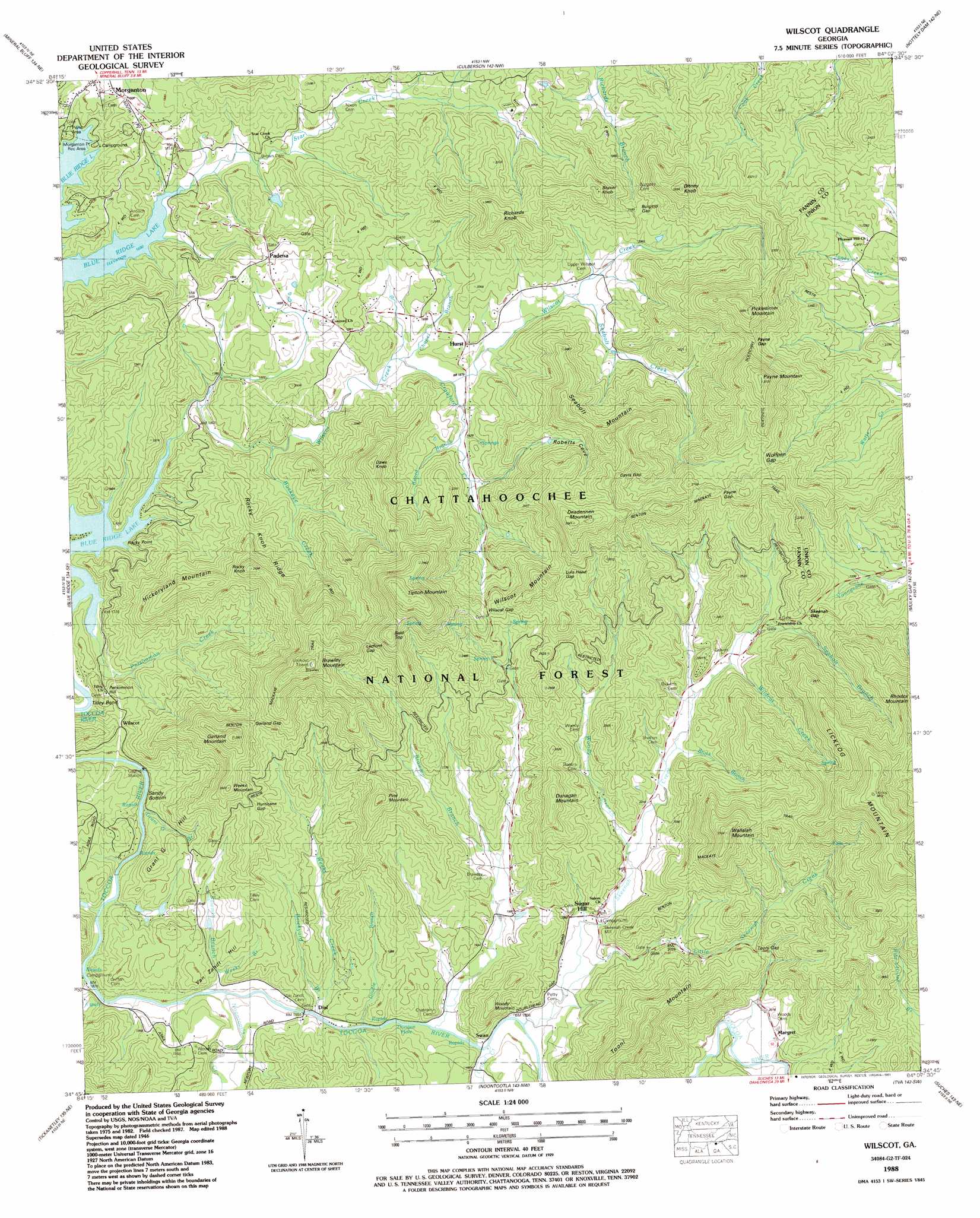
Wilscot Topo Map Georgia
To zoom in, hover over the map of Wilscot
USGS Topo Quad 34084g2 - 1:24,000 scale
| Topo Map Name: | Wilscot |
| USGS Topo Quad ID: | 34084g2 |
| Print Size: | ca. 21 1/4" wide x 27" high |
| Southeast Coordinates: | 34.75° N latitude / 84.125° W longitude |
| Map Center Coordinates: | 34.8125° N latitude / 84.1875° W longitude |
| U.S. State: | GA |
| Filename: | o34084g2.jpg |
| Download Map JPG Image: | Wilscot topo map 1:24,000 scale |
| Map Type: | Topographic |
| Topo Series: | 7.5´ |
| Map Scale: | 1:24,000 |
| Source of Map Images: | United States Geological Survey (USGS) |
| Alternate Map Versions: |
Wilscot GA 1935 Download PDF Buy paper map Wilscot GA 1946, updated 1956 Download PDF Buy paper map Wilscot GA 1946, updated 1969 Download PDF Buy paper map Wilscot GA 1946, updated 1975 Download PDF Buy paper map Wilscot GA 1946, updated 1984 Download PDF Buy paper map Wilscot GA 1947, updated 1947 Download PDF Buy paper map Wilscot GA 2011 Download PDF Buy paper map Wilscot GA 2014 Download PDF Buy paper map |
| FStopo: | US Forest Service topo Wilscot is available: Download FStopo PDF Download FStopo TIF |
1:24,000 Topo Quads surrounding Wilscot
Ducktown |
Isabella |
Persimmon Creek |
Murphy |
Peachtree |
Epworth |
Mineral Bluff |
Culberson |
Nottely Dam |
Blairsville |
Cashes Valley |
Blue Ridge |
Wilscot |
Mulky Gap |
Coosa Bald |
Ellijay |
Tickanetley |
Noontootla |
Suches |
Neels Gap |
Dyke |
Amicalola |
Nimblewill |
Campbell Mountain |
Dahlonega |
> Back to 34084e1 at 1:100,000 scale
> Back to 34084a1 at 1:250,000 scale
> Back to U.S. Topo Maps home
Wilscot topo map: Gazetteer
Wilscot: Bends
Tilley Bend elevation 516m 1692′Wilscot: Capes
Rocky Point elevation 516m 1692′Wilscot: Dams
Kleier Lake Dam elevation 562m 1843′Wilscot: Flats
Sandy Bottom elevation 550m 1804′Wilscot: Gaps
Burgess Gap elevation 661m 2168′Davis Gap elevation 855m 2805′
Garland Gap elevation 735m 2411′
Hurricane Gap elevation 711m 2332′
Ledford Gap elevation 801m 2627′
Lula Head Gap elevation 784m 2572′
Payne Gap elevation 811m 2660′
Payne Gap elevation 786m 2578′
Skeenah Gap elevation 729m 2391′
Tooni Gap elevation 670m 2198′
Wilscot Gap elevation 743m 2437′
Wolfpen Gap elevation 812m 2664′
Wilscot: Populated Places
Craytonia elevation 651m 2135′Dial elevation 563m 1847′
Hurst elevation 597m 1958′
Margret elevation 610m 2001′
Padena elevation 618m 2027′
Sugar Hill elevation 591m 1938′
Swan elevation 573m 1879′
Wilscot elevation 576m 1889′
Wilscot: Rapids
Doogan Hole elevation 569m 1866′Wilscot: Reservoirs
Kleier Lake elevation 562m 1843′Wilscot: Ridges
Rocky Knob Ridge elevation 680m 2230′Wilscot: Streams
Big Creek elevation 552m 1811′Board Branch elevation 588m 1929′
Brawley Branch elevation 595m 1952′
Brickyard Branch elevation 562m 1843′
Brock Branch elevation 618m 2027′
Buckeye Creek elevation 534m 1751′
Chapel Branch elevation 561m 1840′
Crawford Creek elevation 568m 1863′
Double Branch elevation 561m 1840′
Grant G Branch elevation 546m 1791′
Laurel Creek elevation 564m 1850′
Little Skeenah Creek elevation 573m 1879′
Noontootla Creek elevation 557m 1827′
Persimmon Creek elevation 515m 1689′
Pigeon Creek elevation 565m 1853′
Sawmill Branch elevation 556m 1824′
Seabolt Branch elevation 661m 2168′
Seabolt Creek elevation 598m 1961′
Skeenah Creek elevation 565m 1853′
Star Creek elevation 515m 1689′
Weeks Branch elevation 568m 1863′
Weeks Creek elevation 560m 1837′
Wildcat Creek elevation 645m 2116′
Wilscot Creek elevation 518m 1699′
Woody Branch elevation 597m 1958′
Wilscot: Summits
Bald Top elevation 890m 2919′Beaver Knob elevation 766m 2513′
Brawley Mountain elevation 916m 3005′
Daws Knob elevation 782m 2565′
Deadennen Mountain elevation 920m 3018′
Ditney Knob elevation 816m 2677′
Dunagan Mountain elevation 779m 2555′
Garland Mountain elevation 850m 2788′
Grant G Hill elevation 643m 2109′
Hickoryland Mountain elevation 741m 2431′
Licklog Mountain elevation 1061m 3480′
Payne Mountain elevation 956m 3136′
Persimmon Hill elevation 584m 1916′
Picklesimer Mountain elevation 939m 3080′
Pine Mountain elevation 802m 2631′
Richards Knob elevation 772m 2532′
Rocky Knob elevation 779m 2555′
Seabolt Mountain elevation 798m 2618′
Tipton Mountain elevation 961m 3152′
Tooni Mountain elevation 822m 2696′
Van Zandt Hill elevation 613m 2011′
Wallalah Mountain elevation 942m 3090′
Weeks Mountain elevation 794m 2604′
Wilscot Mountain elevation 851m 2791′
Woody Mountain elevation 687m 2253′
Wilscot: Trails
Benton Mackaye Trail elevation 819m 2687′Wilscot: Valleys
Roberts Cove elevation 621m 2037′Wilscot digital topo map on disk
Buy this Wilscot topo map showing relief, roads, GPS coordinates and other geographical features, as a high-resolution digital map file on DVD: