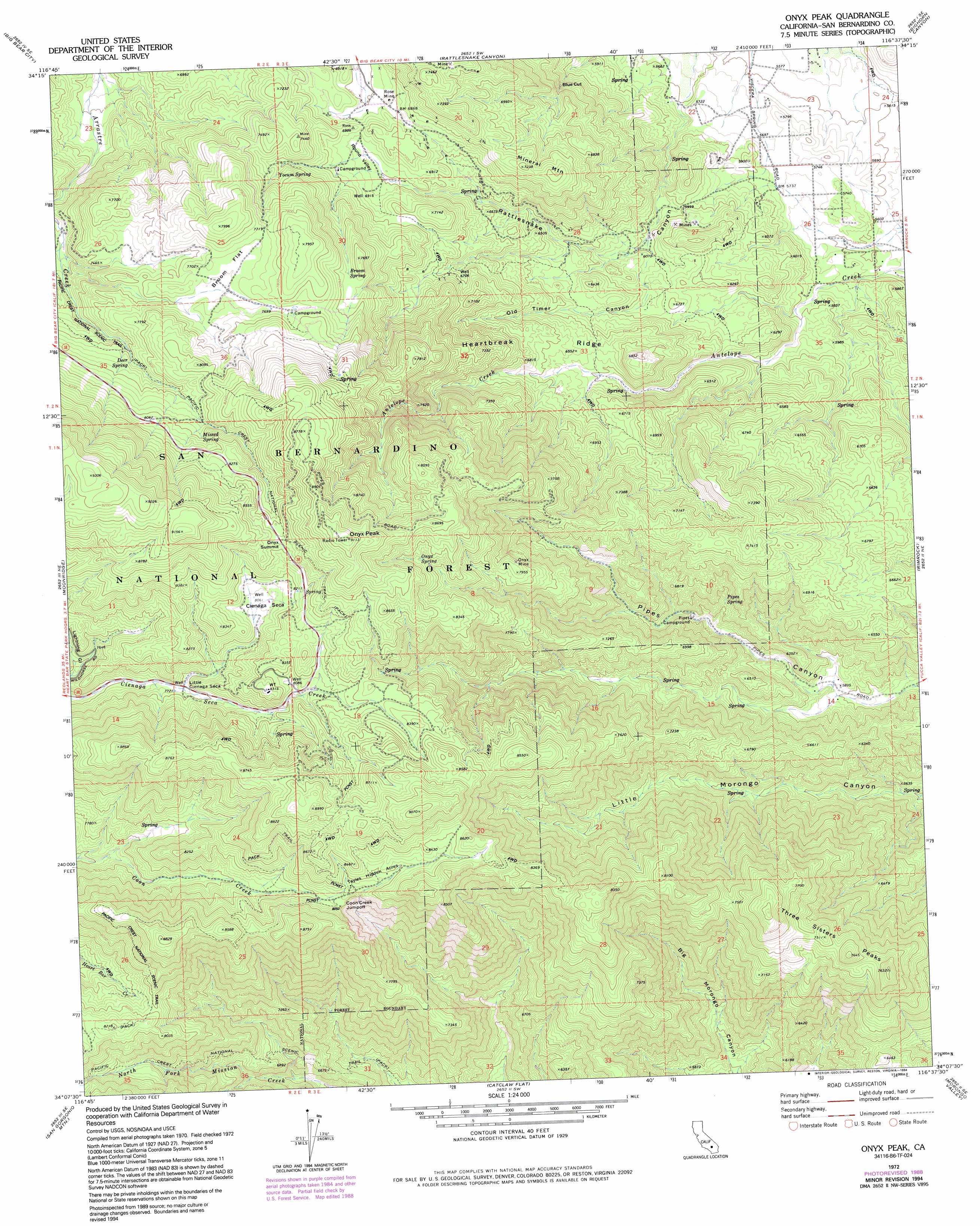
Onyx Peak Topo Map California
To zoom in, hover over the map of Onyx Peak
USGS Topo Quad 34116b6 - 1:24,000 scale
| Topo Map Name: | Onyx Peak |
| USGS Topo Quad ID: | 34116b6 |
| Print Size: | ca. 21 1/4" wide x 27" high |
| Southeast Coordinates: | 34.125° N latitude / 116.625° W longitude |
| Map Center Coordinates: | 34.1875° N latitude / 116.6875° W longitude |
| U.S. State: | CA |
| Filename: | o34116b6.jpg |
| Download Map JPG Image: | Onyx Peak topo map 1:24,000 scale |
| Map Type: | Topographic |
| Topo Series: | 7.5´ |
| Map Scale: | 1:24,000 |
| Source of Map Images: | United States Geological Survey (USGS) |
| Alternate Map Versions: |
Onyx Peak CA 1972, updated 1975 Download PDF Buy paper map Onyx Peak CA 1972, updated 1988 Download PDF Buy paper map Onyx Peak CA 1972, updated 1994 Download PDF Buy paper map Onyx Peak CA 1996, updated 1999 Download PDF Buy paper map Onyx Peak CA 2012 Download PDF Buy paper map Onyx Peak CA 2015 Download PDF Buy paper map |
| FStopo: | US Forest Service topo Onyx Peak is available: Download FStopo PDF Download FStopo TIF |
1:24,000 Topo Quads surrounding Onyx Peak
Lucerne Valley |
Cougar Buttes |
Old Woman Springs |
Melville Lake |
Emerson Lake |
Fawnskin |
Big Bear City |
Rattlesnake Canyon |
Bighorn Canyon |
Landers |
Big Bear Lake |
Moonridge |
Onyx Peak |
Rimrock |
Yucca Valley North |
Forest Falls |
San Gorgonio Mountain |
Catclaw Flat |
Morongo Valley |
Yucca Valley South |
Beaumont |
Cabazon |
White Water |
Desert Hot Springs |
Seven Palms Valley |
> Back to 34116a1 at 1:100,000 scale
> Back to 34116a1 at 1:250,000 scale
> Back to U.S. Topo Maps home
Onyx Peak topo map: Gazetteer
Onyx Peak: Areas
Coon Creek Jumpoff elevation 2453m 8047′Tayles Hidden Acres elevation 2491m 8172′
Onyx Peak: Flats
Broom Flat elevation 2329m 7641′Onyx Peak: Gaps
Blue Cut elevation 1922m 6305′Onyx Summit elevation 2576m 8451′
Onyx Peak: Mines
Monte Cristo Mine elevation 2118m 6948′Onyx Mine elevation 2404m 7887′
Rose Mine elevation 2095m 6873′
Onyx Peak: Plains
Cienaga Seca elevation 2455m 8054′Onyx Peak: Ridges
Heartbreak Ridge elevation 2018m 6620′Onyx Peak: Springs
Broom Spring elevation 2290m 7513′Deer Spring elevation 2328m 7637′
Missed Spring elevation 2438m 7998′
Onyx Spring elevation 2525m 8284′
Pipes Spring elevation 1993m 6538′
Yocum Spring elevation 2215m 7267′
Onyx Peak: Summits
Mineral Mountain elevation 2200m 7217′Three Sisters Peaks elevation 2326m 7631′
Onyx Peak: Swamps
Little Cienaga Seca elevation 2363m 7752′Onyx Peak: Valleys
Old Timer Canyon elevation 1819m 5967′Round Valley elevation 2077m 6814′
Onyx Peak digital topo map on disk
Buy this Onyx Peak topo map showing relief, roads, GPS coordinates and other geographical features, as a high-resolution digital map file on DVD: