Lake Wylie Topo Map South Carolina
To zoom in, hover over the map of Lake Wylie
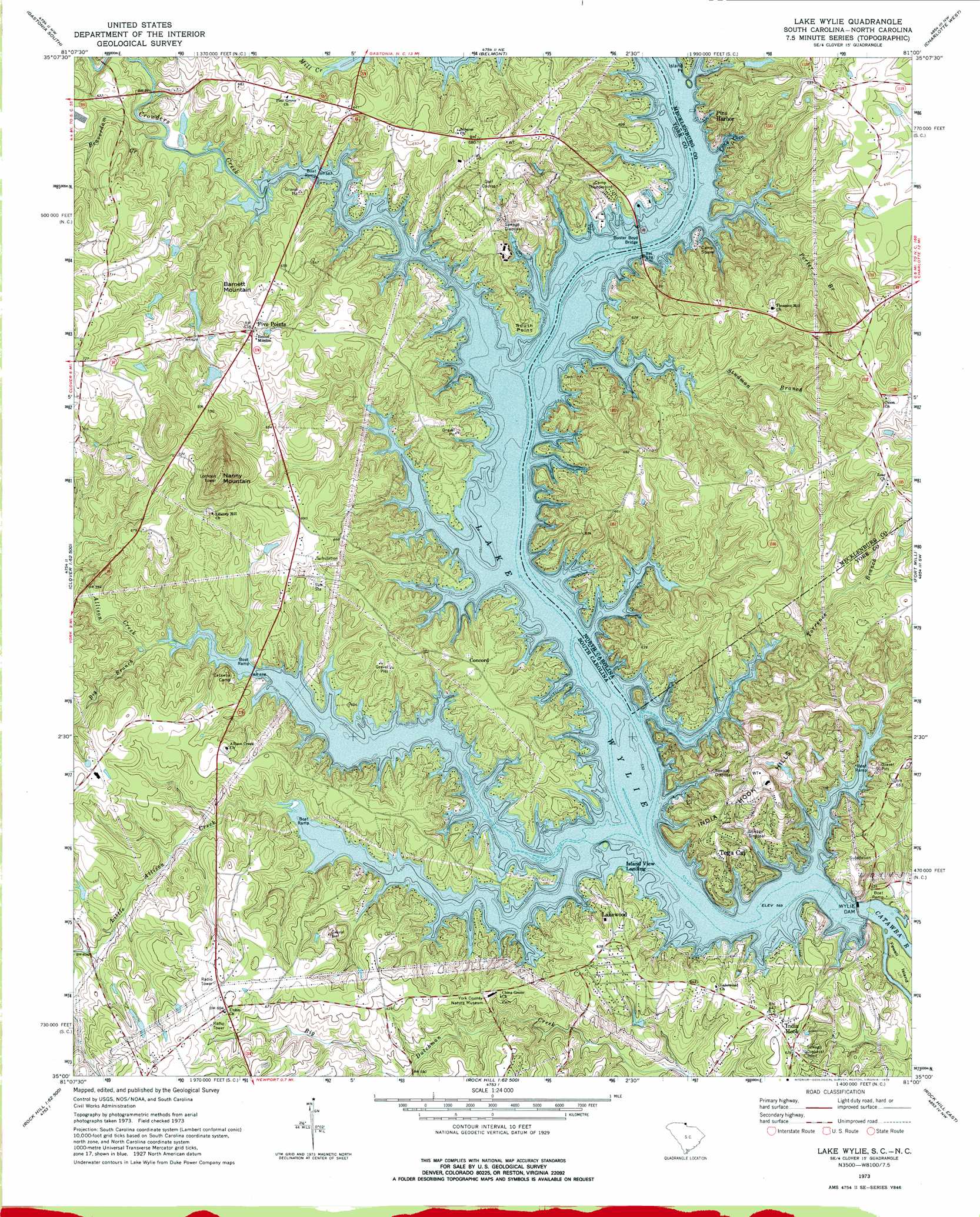
USGS Topo Quad 35081a1 - 1:24,000 scale
| Topo Map Name: | Lake Wylie |
| USGS Topo Quad ID: | 35081a1 |
| Print Size: | ca. 21 1/4" wide x 27" high |
| Southeast Coordinates: | 35° N latitude / 81° W longitude |
| Map Center Coordinates: | 35.0625° N latitude / 81.0625° W longitude |
| U.S. States: | SC, NC |
| Filename: | o35081a1.jpg |
| Download Map JPG Image: | Lake Wylie topo map 1:24,000 scale |
| Map Type: | Topographic |
| Topo Series: | 7.5´ |
| Map Scale: | 1:24,000 |
| Source of Map Images: | United States Geological Survey (USGS) |
| Alternate Map Versions: |
Lake Wylie SC 1973, updated 1976 Download PDF Buy paper map Lake Wylie SC 1993, updated 1996 Download PDF Buy paper map Lake Wylie SC 2011 Download PDF Buy paper map Lake Wylie SC 2014 Download PDF Buy paper map |
1:24,000 Topo Quads surrounding Lake Wylie
Bessemer City |
Gastonia North |
Mount Holly |
Mountain Island Lake |
Derita |
Kings Mountain |
Gastonia South |
Belmont |
Charlotte West |
Charlotte East |
Filbert |
Clover |
Lake Wylie |
Fort Mill |
Weddington |
Sharon |
Tirzah |
Rock Hill West |
Rock Hill East |
Catawba Ne |
Armenia |
Lowrys |
Edgemoor |
Catawba |
Van Wyck |
> Back to 35081a1 at 1:100,000 scale
> Back to 35080a1 at 1:250,000 scale
> Back to U.S. Topo Maps home
Lake Wylie topo map: Gazetteer
Lake Wylie: Airports
Bar-Fly Corporation Airport elevation 218m 715′Lake Wylie: Bays
Long Cove elevation 173m 567′Lake Wylie: Bridges
Buster Boyd Bridge elevation 165m 541′Buster Boyd Bridge elevation 166m 544′
Lake Wylie: Capes
Commodore Point elevation 172m 564′Island Point elevation 183m 600′
South Point elevation 186m 610′
Lake Wylie: Crossings
Masons Ferry (historical) elevation 161m 528′Thorns Ferry (historical) elevation 160m 524′
Lake Wylie: Dams
Ford Pond Dam D-3675 elevation 195m 639′Thomas Pond Dam D-3676 elevation 205m 672′
Wylie Dam elevation 159m 521′
Lake Wylie: Islands
Fewell Island elevation 159m 521′Long Island (historical) elevation 161m 528′
Lake Wylie: Parks
Bali Beach Park elevation 178m 583′McDowell Park elevation 197m 646′
Pitcairn Cove Beach Park elevation 177m 580′
Lake Wylie: Populated Places
Belmont (historical) elevation 195m 639′Catawba Ridge elevation 179m 587′
Cedarwood elevation 190m 623′
Concord elevation 195m 639′
Fairway Bridge elevation 198m 649′
Five Points elevation 206m 675′
Forest Acres elevation 189m 620′
Heritage Woods elevation 202m 662′
Hickory Hill elevation 193m 633′
Hollyberry Woods elevation 194m 636′
Honeysuckle Woods elevation 201m 659′
India Hook elevation 194m 636′
Island View Landing elevation 174m 570′
Lake Wylie elevation 178m 583′
Lakewood elevation 190m 623′
Lakewood Acres elevation 191m 626′
Oakwood elevation 196m 643′
Pine Harbor elevation 173m 567′
River Hills Plantation elevation 198m 649′
River Pines elevation 203m 666′
South Point elevation 187m 613′
Sunrise Point elevation 186m 610′
Tega Cay elevation 192m 629′
Timber Ridge elevation 183m 600′
Lake Wylie: Ranges
India Hook Hills elevation 220m 721′Lake Wylie: Reservoirs
Lake Wylie elevation 159m 521′Lake Wylie: Streams
Allison Creek elevation 160m 524′Beaverdam Creek elevation 173m 567′
Big Branch elevation 173m 567′
Crowders Creek elevation 161m 528′
Little Allison Creek elevation 171m 561′
Porter Branch elevation 173m 567′
Studman Branch elevation 161m 528′
Torrence Branch elevation 161m 528′
Torrence Branch elevation 161m 528′
Lake Wylie: Summits
Barnett Mountain elevation 219m 718′Nanny Mountain elevation 293m 961′
Lake Wylie digital topo map on disk
Buy this Lake Wylie topo map showing relief, roads, GPS coordinates and other geographical features, as a high-resolution digital map file on DVD:
South Carolina, Western North Carolina & Northeastern Georgia
Buy digital topo maps: South Carolina, Western North Carolina & Northeastern Georgia