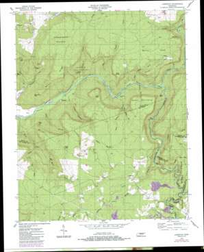
Lonewood Topo Map Tennessee
To zoom in, hover over the map of Lonewood
USGS Topo Quad 35085g3 - 1:24,000 scale
| Topo Map Name: | Lonewood |
| USGS Topo Quad ID: | 35085g3 |
| Print Size: | ca. 21 1/4" wide x 27" high |
| Southeast Coordinates: | 35.75° N latitude / 85.25° W longitude |
| Map Center Coordinates: | 35.8125° N latitude / 85.3125° W longitude |
| U.S. State: | TN |
| Filename: | o35085g3.jpg |
| Download Map JPG Image: | Lonewood topo map 1:24,000 scale |
| Map Type: | Topographic |
| Topo Series: | 7.5´ |
| Map Scale: | 1:24,000 |
| Source of Map Images: | United States Geological Survey (USGS) |
| Alternate Map Versions: |
Lonewood TN 1954, updated 1955 Download PDF Buy paper map Lonewood TN 1954, updated 1972 Download PDF Buy paper map Lonewood TN 1954, updated 1977 Download PDF Buy paper map Lonewood TN 1954, updated 1984 Download PDF Buy paper map Lonewood TN 2010 Download PDF Buy paper map Lonewood TN 2013 Download PDF Buy paper map Lonewood TN 2016 Download PDF Buy paper map |
1:24,000 Topo Quads surrounding Lonewood
> Back to 35085e1 at 1:100,000 scale
> Back to 35084a1 at 1:250,000 scale
> Back to U.S. Topo Maps home
Lonewood topo map: Gazetteer
Lonewood: Basins
Big Sink elevation 379m 1243′Hell Hole elevation 444m 1456′
Mill Hole elevation 307m 1007′
Lonewood: Bends
Big Bottom elevation 256m 839′Lonewood: Capes
McCager Point elevation 524m 1719′Lonewood: Cliffs
Copper Cliff elevation 470m 1541′Lonewood: Crossings
Cedar Shoals Ford elevation 272m 892′Lonewood: Falls
Virgin Falls elevation 331m 1085′Lonewood: Gaps
Berkshire Gap elevation 405m 1328′Sally Gap elevation 502m 1646′
Shop Gap elevation 515m 1689′
Lonewood: Lakes
Black Pond elevation 548m 1797′Lonewood: Mines
Woodard Hankins Mine elevation 482m 1581′Lonewood: Parks
Virgin Falls State Natural Area elevation 341m 1118′Lonewood: Populated Places
Bethesda elevation 272m 892′Dodson elevation 250m 820′
Lonewood elevation 519m 1702′
Lonewood: Ridges
Graveyard Ridge elevation 553m 1814′Gross Ridge elevation 534m 1751′
Wilson Ridge elevation 543m 1781′
Lonewood: Streams
Bee Branch elevation 356m 1167′Bee Creek elevation 288m 944′
Big Laurel Creek elevation 268m 879′
Dark Hollow Branch elevation 272m 892′
Flowing Well Branch elevation 508m 1666′
Gastens Branch elevation 258m 846′
Glade Creek elevation 455m 1492′
Gunstock Branch elevation 320m 1049′
Haskens Branch elevation 376m 1233′
Keener Branch elevation 491m 1610′
Little Laurel Creek elevation 262m 859′
Little Sink Branch elevation 334m 1095′
Long Branch elevation 275m 902′
Lost Creek elevation 377m 1236′
Moore Creek elevation 250m 820′
Old Cabin Branch elevation 376m 1233′
Polly Branch elevation 361m 1184′
Simmons Creek elevation 496m 1627′
Spring Creek elevation 394m 1292′
Steep Hollow Branch elevation 281m 921′
Suggs Branch elevation 254m 833′
Lonewood: Summits
Little Chestnut Mountain elevation 588m 1929′Scott Pinnacle elevation 525m 1722′
Welch Knob elevation 539m 1768′
Lonewood: Valleys
Caney Creek Gulch elevation 256m 839′Dog Cove elevation 384m 1259′
Mill Hollow elevation 267m 875′
Scott Gulf elevation 274m 898′
Lonewood digital topo map on disk
Buy this Lonewood topo map showing relief, roads, GPS coordinates and other geographical features, as a high-resolution digital map file on DVD:


