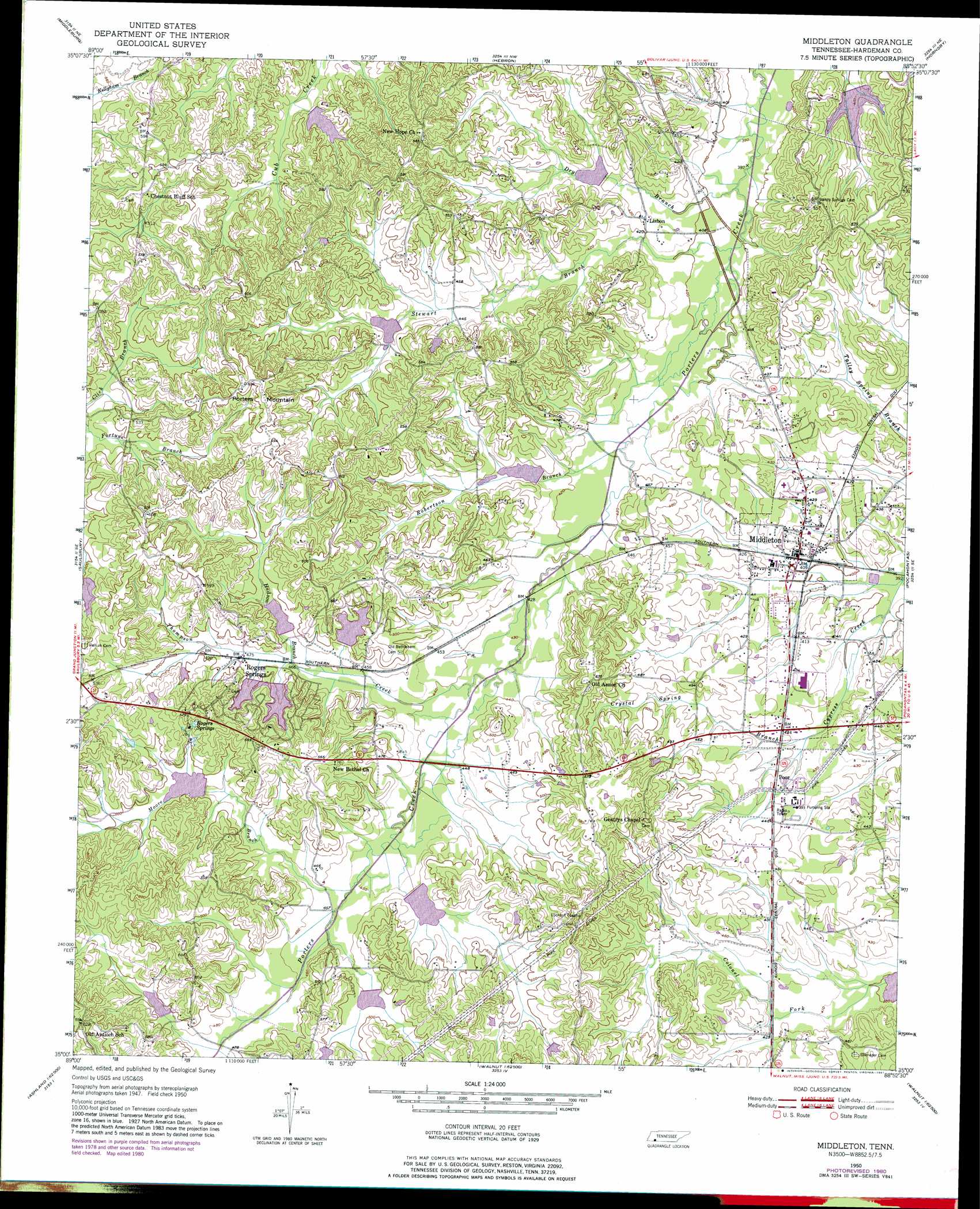
Middleton Topo Map Tennessee
To zoom in, hover over the map of Middleton
USGS Topo Quad 35088a8 - 1:24,000 scale
| Topo Map Name: | Middleton |
| USGS Topo Quad ID: | 35088a8 |
| Print Size: | ca. 21 1/4" wide x 27" high |
| Southeast Coordinates: | 35° N latitude / 88.875° W longitude |
| Map Center Coordinates: | 35.0625° N latitude / 88.9375° W longitude |
| U.S. State: | TN |
| Filename: | o35088a8.jpg |
| Download Map JPG Image: | Middleton topo map 1:24,000 scale |
| Map Type: | Topographic |
| Topo Series: | 7.5´ |
| Map Scale: | 1:24,000 |
| Source of Map Images: | United States Geological Survey (USGS) |
| Alternate Map Versions: |
Middleton TN 1950, updated 1975 Download PDF Buy paper map Middleton TN 1950, updated 1981 Download PDF Buy paper map Middleton TN 1951 Download PDF Buy paper map Middleton TN 2010 Download PDF Buy paper map Middleton TN 2013 Download PDF Buy paper map Middleton TN 2016 Download PDF Buy paper map |
1:24,000 Topo Quads surrounding Middleton
Whiteville |
Bolivar West |
Bolivar East |
Silerton |
Masseyville |
Hickory Valley |
Middleburg |
Hebron |
Hornsby |
Rose Creek |
Grand Junction |
Saulsbury |
Middleton |
Pocahontas |
Chewalla |
Canaan |
Camp Hill |
Walnut |
Chalybeate |
Kossuth North |
Ashland |
Whitten Town |
Falkner |
Peoples |
Kossuth South |
> Back to 35088a1 at 1:100,000 scale
> Back to 35088a1 at 1:250,000 scale
> Back to U.S. Topo Maps home
Middleton topo map: Gazetteer
Middleton: Dams
Cub Creek Tree Farm Dam elevation 143m 469′Porters Creek Dam Number Five elevation 137m 449′
Porters Creek Lake Dam Number Eight elevation 150m 492′
Porters Creek Lake Dam Number Fifteen elevation 147m 482′
Porters Creek Lake Dam Number Four elevation 137m 449′
Porters Creek Lake Dam Number Seven elevation 145m 475′
Porters Creek Lake Dam Number Six elevation 154m 505′
Porters Creek Lake Dam Number Three elevation 130m 426′
Porters Creek Number Sixteen Dam elevation 143m 469′
Rogers Springs Dam elevation 149m 488′
Woodrun Number One Dam West elevation 152m 498′
Woodrun Number Two Dam elevation 153m 501′
Middleton: Populated Places
Lisbon elevation 126m 413′Middleton elevation 127m 416′
Poor elevation 131m 429′
Rogers Springs elevation 144m 472′
Middleton: Post Offices
Middleton Post Office elevation 127m 416′Middleton: Reservoirs
Cub Creek Tree Farm Lake elevation 143m 469′Porters Creek Lake Number Eight elevation 150m 492′
Porters Creek Lake Number Fifteen elevation 147m 482′
Porters Creek Lake Number Five elevation 137m 449′
Porters Creek Lake Number Four elevation 137m 449′
Porters Creek Lake Number Seven elevation 145m 475′
Porters Creek Lake Number Six elevation 154m 505′
Porters Creek Lake Number Three elevation 130m 426′
Porters Creek Watershed Number Sixteen Lake elevation 143m 469′
Rogers Spring Lake elevation 149m 488′
Woodrun Lake Number One elevation 152m 498′
Woodrun Lake Number Two elevation 153m 501′
Middleton: Springs
Rogers Springs elevation 162m 531′Middleton: Streams
Crystal Spring Branch elevation 125m 410′Dry Branch elevation 119m 390′
Hudson Branch elevation 140m 459′
Moore Branch elevation 137m 449′
Robertson Branch elevation 125m 410′
Stewart Branch elevation 121m 396′
Thompson Creek elevation 131m 429′
Yopp Branch elevation 144m 472′
Yopp Branch elevation 144m 472′
Middleton: Summits
Porters Mountain elevation 190m 623′Middleton digital topo map on disk
Buy this Middleton topo map showing relief, roads, GPS coordinates and other geographical features, as a high-resolution digital map file on DVD: