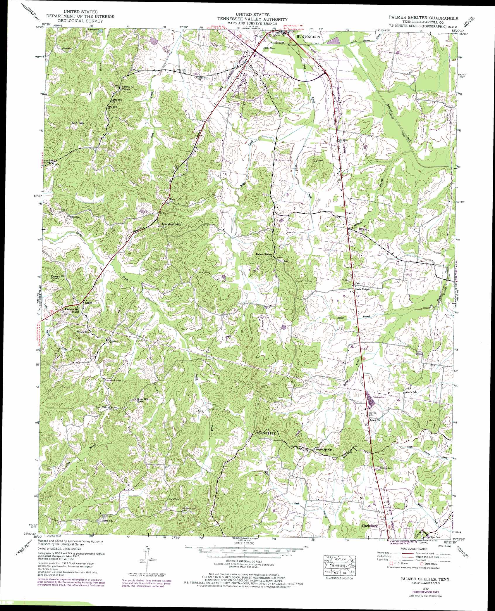
Palmer Shelter Topo Map Tennessee
To zoom in, hover over the map of Palmer Shelter
USGS Topo Quad 35088h4 - 1:24,000 scale
| Topo Map Name: | Palmer Shelter |
| USGS Topo Quad ID: | 35088h4 |
| Print Size: | ca. 21 1/4" wide x 27" high |
| Southeast Coordinates: | 35.875° N latitude / 88.375° W longitude |
| Map Center Coordinates: | 35.9375° N latitude / 88.4375° W longitude |
| U.S. State: | TN |
| Filename: | o35088h4.jpg |
| Download Map JPG Image: | Palmer Shelter topo map 1:24,000 scale |
| Map Type: | Topographic |
| Topo Series: | 7.5´ |
| Map Scale: | 1:24,000 |
| Source of Map Images: | United States Geological Survey (USGS) |
| Alternate Map Versions: |
Center Ridge TN 1936 Download PDF Buy paper map Palmer Shelter TN 1950, updated 1953 Download PDF Buy paper map Palmer Shelter TN 1950, updated 1965 Download PDF Buy paper map Palmer Shelter TN 1950, updated 1974 Download PDF Buy paper map Palmer Shelter TN 2010 Download PDF Buy paper map Palmer Shelter TN 2013 Download PDF Buy paper map Palmer Shelter TN 2016 Download PDF Buy paper map |
1:24,000 Topo Quads surrounding Palmer Shelter
Pillowville |
Mckenzie |
Henry |
Mansfield |
Manleyville |
Trezevant West |
Trezevant East |
Huntingdon |
Vale |
Bruceton |
Atwood |
Mclemoresville |
Palmer Shelter |
Buena Vista |
Seventeen Creek |
Spring Creek |
Cedar Grove |
Clarksburg |
Yuma |
Holladay |
Claybrook |
Juno |
Lexington |
Chesterfield |
Parsons |
> Back to 35088e1 at 1:100,000 scale
> Back to 35088a1 at 1:250,000 scale
> Back to U.S. Topo Maps home
Palmer Shelter topo map: Gazetteer
Palmer Shelter: Airports
Huntingdon Airport elevation 120m 393′Palmer Shelter: Dams
Ernest Vickers Dam elevation 129m 423′Palmer Shelter: Populated Places
Anark elevation 140m 459′Davis Chapel elevation 140m 459′
Hillard elevation 126m 413′
Lakewood elevation 151m 495′
Leach elevation 174m 570′
Poplar Springs elevation 163m 534′
Scott Hill elevation 191m 626′
Tate elevation 178m 583′
Palmer Shelter: Reservoirs
Ernest Vickers Lake elevation 129m 423′Palmer Shelter: Streams
Brier Creek elevation 113m 370′Butler Branch elevation 123m 403′
Hillard Branch elevation 115m 377′
Little Beaver Creek elevation 115m 377′
Mud Creek elevation 116m 380′
Northwood Branch elevation 115m 377′
Palmer Shelter: Summits
Marshall Hill elevation 184m 603′Slip Top elevation 183m 600′
Palmer Shelter digital topo map on disk
Buy this Palmer Shelter topo map showing relief, roads, GPS coordinates and other geographical features, as a high-resolution digital map file on DVD: