Buena Vista Topo Map Tennessee
To zoom in, hover over the map of Buena Vista
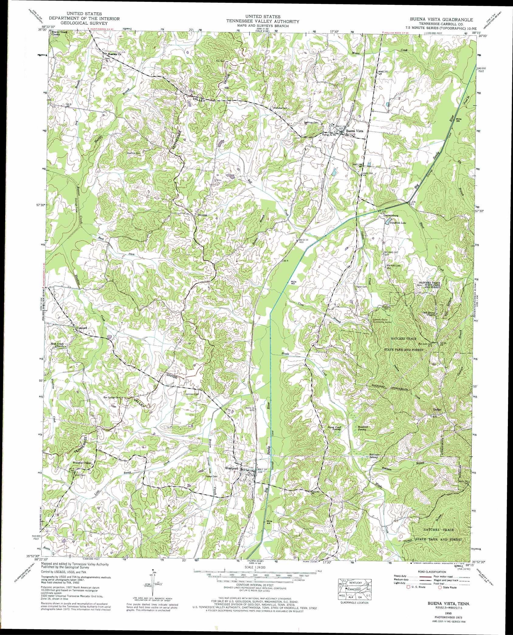
USGS Topo Quad 35088h3 - 1:24,000 scale
| Topo Map Name: | Buena Vista |
| USGS Topo Quad ID: | 35088h3 |
| Print Size: | ca. 21 1/4" wide x 27" high |
| Southeast Coordinates: | 35.875° N latitude / 88.25° W longitude |
| Map Center Coordinates: | 35.9375° N latitude / 88.3125° W longitude |
| U.S. State: | TN |
| Filename: | o35088h3.jpg |
| Download Map JPG Image: | Buena Vista topo map 1:24,000 scale |
| Map Type: | Topographic |
| Topo Series: | 7.5´ |
| Map Scale: | 1:24,000 |
| Source of Map Images: | United States Geological Survey (USGS) |
| Alternate Map Versions: |
Buena Vista TN 1936 Download PDF Buy paper map Buena Vista TN 1950, updated 1953 Download PDF Buy paper map Buena Vista TN 1950, updated 1964 Download PDF Buy paper map Buena Vista TN 1950, updated 1974 Download PDF Buy paper map Buena Vista TN 2010 Download PDF Buy paper map Buena Vista TN 2013 Download PDF Buy paper map Buena Vista TN 2016 Download PDF Buy paper map |
1:24,000 Topo Quads surrounding Buena Vista
Mckenzie |
Henry |
Mansfield |
Manleyville |
Big Sandy |
Trezevant East |
Huntingdon |
Vale |
Bruceton |
Camden |
Mclemoresville |
Palmer Shelter |
Buena Vista |
Seventeen Creek |
Rockport |
Cedar Grove |
Clarksburg |
Yuma |
Holladay |
Sugar Tree |
Juno |
Lexington |
Chesterfield |
Parsons |
Jeanette |
> Back to 35088e1 at 1:100,000 scale
> Back to 35088a1 at 1:250,000 scale
> Back to U.S. Topo Maps home
Buena Vista topo map: Gazetteer
Buena Vista: Populated Places
Buena Vista elevation 155m 508′Concord elevation 141m 462′
Cross Roads elevation 143m 469′
Dollar elevation 192m 629′
Garrettsburg elevation 131m 429′
Mount Zion elevation 122m 400′
Smyrna elevation 157m 515′
Spanish Grove elevation 154m 505′
Westport elevation 143m 469′
Williams Chapel elevation 158m 518′
Buena Vista: Post Offices
Buena Vista Post Office elevation 155m 508′Westport Post Office elevation 132m 433′
Buena Vista: Reservoirs
Sunshine Lake elevation 129m 423′Buena Vista: Streams
Bacon Creek elevation 124m 406′Bateman Branch elevation 136m 446′
Bell Creek elevation 124m 406′
Blunt Creek elevation 122m 400′
Buck Ditch elevation 119m 390′
Crow Branch elevation 123m 403′
Dawson Branch elevation 129m 423′
Dry Branch elevation 121m 396′
Eli Branch elevation 121m 396′
Haines Branch elevation 132m 433′
Hawkins Creek elevation 121m 396′
Humble Branch elevation 119m 390′
Indian Creek elevation 123m 403′
Little Bacon Creek elevation 128m 419′
Lyle Branch elevation 121m 396′
Maple Creek elevation 123m 403′
Moore Creek elevation 121m 396′
Pond Branch elevation 121m 396′
Thomas Branch elevation 142m 465′
Buena Vista: Swamps
Bradford Swamp elevation 136m 446′Goose Pond Swamp elevation 137m 449′
Robinson Swamp elevation 136m 446′
Buena Vista digital topo map on disk
Buy this Buena Vista topo map showing relief, roads, GPS coordinates and other geographical features, as a high-resolution digital map file on DVD: