Cleveland Topo Map Arkansas
To zoom in, hover over the map of Cleveland
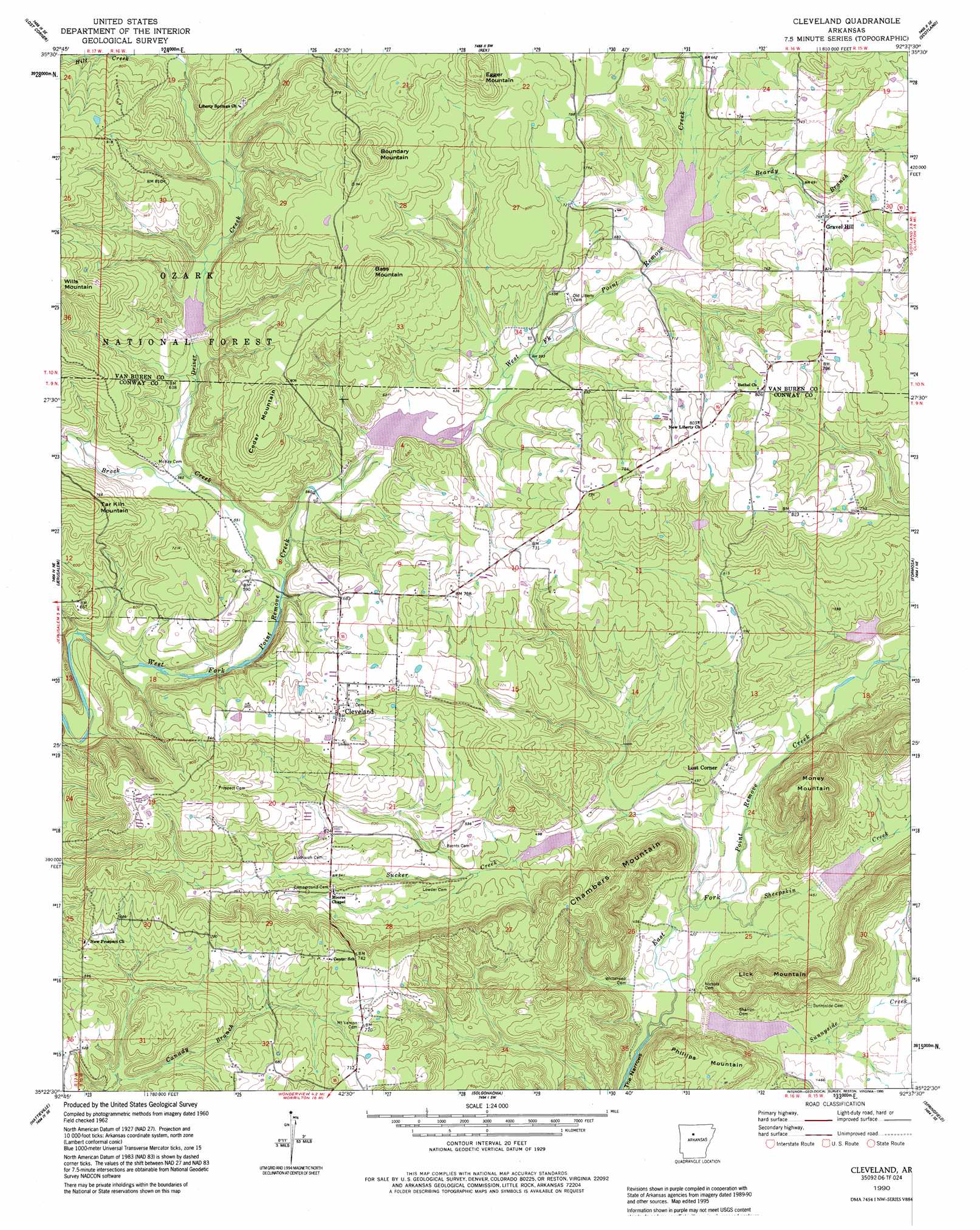
USGS Topo Quad 35092d6 - 1:24,000 scale
| Topo Map Name: | Cleveland |
| USGS Topo Quad ID: | 35092d6 |
| Print Size: | ca. 21 1/4" wide x 27" high |
| Southeast Coordinates: | 35.375° N latitude / 92.625° W longitude |
| Map Center Coordinates: | 35.4375° N latitude / 92.6875° W longitude |
| U.S. State: | AR |
| Filename: | o35092d6.jpg |
| Download Map JPG Image: | Cleveland topo map 1:24,000 scale |
| Map Type: | Topographic |
| Topo Series: | 7.5´ |
| Map Scale: | 1:24,000 |
| Source of Map Images: | United States Geological Survey (USGS) |
| Alternate Map Versions: |
Cleveland AR 1962, updated 1963 Download PDF Buy paper map Cleveland AR 1962, updated 1978 Download PDF Buy paper map Cleveland AR 1990, updated 1995 Download PDF Buy paper map Cleveland AR 2011 Download PDF Buy paper map Cleveland AR 2014 Download PDF Buy paper map |
| FStopo: | US Forest Service topo Cleveland is available: Download FStopo PDF Download FStopo TIF |
1:24,000 Topo Quads surrounding Cleveland
Smyrna |
Tilly |
Alread |
Botkinburg |
Old Lexington |
Solo |
Lost Corner |
Rex |
Scotland |
Clinton |
Hector |
Jerusalem |
Cleveland |
Formosa |
Bee Branch |
Moreland |
Hattieville |
Solgohachia |
Springfield |
Damascus |
Atkins |
Morrilton West |
Morrilton East |
Menifee |
Greenbrier |
> Back to 35092a1 at 1:100,000 scale
> Back to 35092a1 at 1:250,000 scale
> Back to U.S. Topo Maps home
Cleveland topo map: Gazetteer
Cleveland: Channels
The Narrows elevation 138m 452′Cleveland: Dams
East Fork Point Remove Site Five Dam elevation 149m 488′East Fork Point Remove Site Four Dam elevation 145m 475′
East Fork Point Remove Site Six Dam elevation 144m 472′
East Fork Point Remove Site Three Dam elevation 147m 482′
West Fork Point Remove Creek Site Four Dam elevation 172m 564′
West Fork Point Remove Creek Site One Dam elevation 201m 659′
West Fork Point Remove Creek Site Two Dam elevation 192m 629′
Cleveland: Populated Places
Blick elevation 214m 702′Cleveland elevation 220m 721′
Gravel Hill elevation 227m 744′
Liberty Springs (historical) elevation 214m 702′
Lost Corner elevation 140m 459′
Old Liberty (historical) elevation 199m 652′
Cleveland: Post Offices
Cleveland Post Office elevation 220m 721′Cleveland: Reservoirs
Driver Creek Lake elevation 185m 606′Drivers Creek Lake elevation 192m 629′
East Fork Point Remove Site Five Reservoir elevation 149m 488′
East Fork Point Remove Site Four Reservoir elevation 145m 475′
East Fork Point Remove Site Six Reservoir elevation 144m 472′
East Fork Point Remove Site Three Reservoir elevation 147m 482′
West Fork Point Remove Creek Site Four Reservoir elevation 172m 564′
West Fork Point Remove Creek Site One Reservoir elevation 201m 659′
Cleveland: Streams
Beardy Branch elevation 192m 629′Brock Creek elevation 164m 538′
Driver Creek elevation 181m 593′
Sheepskin Creek elevation 126m 413′
Sucker Creek elevation 125m 410′
Sunnyside Creek elevation 122m 400′
Cleveland: Summits
Bass Mountain elevation 297m 974′Boundary Mountain elevation 310m 1017′
Cedar Mountain elevation 282m 925′
Chambers Mountain elevation 220m 721′
Egger Mountain elevation 306m 1003′
Lick Mountain elevation 233m 764′
Money Mountain elevation 271m 889′
Phillips Mountain elevation 209m 685′
Cleveland digital topo map on disk
Buy this Cleveland topo map showing relief, roads, GPS coordinates and other geographical features, as a high-resolution digital map file on DVD: