Magazine Mountain Ne Topo Map Arkansas
To zoom in, hover over the map of Magazine Mountain Ne
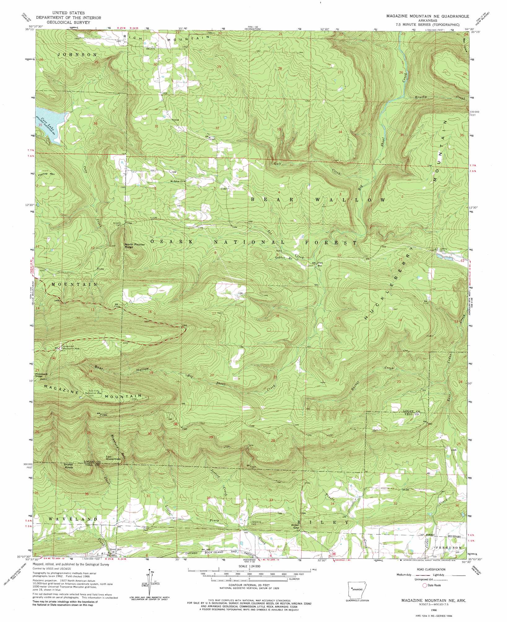
USGS Topo Quad 35093b5 - 1:24,000 scale
| Topo Map Name: | Magazine Mountain Ne |
| USGS Topo Quad ID: | 35093b5 |
| Print Size: | ca. 21 1/4" wide x 27" high |
| Southeast Coordinates: | 35.125° N latitude / 93.5° W longitude |
| Map Center Coordinates: | 35.1875° N latitude / 93.5625° W longitude |
| U.S. State: | AR |
| Filename: | o35093b5.jpg |
| Download Map JPG Image: | Magazine Mountain Ne topo map 1:24,000 scale |
| Map Type: | Topographic |
| Topo Series: | 7.5´ |
| Map Scale: | 1:24,000 |
| Source of Map Images: | United States Geological Survey (USGS) |
| Alternate Map Versions: |
Magazine Mountain NE AR 1966, updated 1967 Download PDF Buy paper map Magazine Mountain NE AR 1966, updated 1979 Download PDF Buy paper map Magazine Mountain NE AR 2011 Download PDF Buy paper map Magazine Mountain NE AR 2014 Download PDF Buy paper map |
| FStopo: | US Forest Service topo Magazine Mountain NE is available: Download FStopo PDF Download FStopo TIF |
1:24,000 Topo Quads surrounding Magazine Mountain Ne
Ozark |
Coal Hill |
Hartman |
Clarksville |
Knoxville |
Caulksville |
Paris |
Scranton |
New Blaine |
Delaware |
Magazine |
Blue Mountain |
Magazine Mountain Ne |
Chickalah Mountain West |
Chickalah Mountain East |
Sugar Grove |
Blue Mountain Dam |
Havana |
Danville |
Danville Mountain |
Freedom Mountain |
Gravelly |
Bluffton |
Rover |
Plainview |
> Back to 35093a1 at 1:100,000 scale
> Back to 35092a1 at 1:250,000 scale
> Back to U.S. Topo Maps home
Magazine Mountain Ne topo map: Gazetteer
Magazine Mountain Ne: Bays
Mountain Hole elevation 177m 580′Magazine Mountain Ne: Gaps
Alder Gap elevation 137m 449′Magazine Mountain Ne: Parks
East End Recreation Area elevation 720m 2362′Greenfield Recreation Area elevation 737m 2417′
Magazine Mountain Ne: Reservoirs
Cove Lake elevation 323m 1059′Magazine Mountain Ne: Ridges
North Pointer Ridge elevation 401m 1315′Magazine Mountain Ne: Streams
Barber Creek elevation 199m 652′Big Piney Creek elevation 158m 518′
Brushy Creek elevation 200m 656′
Gobbel Branch elevation 277m 908′
Gulf Creek elevation 217m 711′
Jestice Creek elevation 134m 439′
Lee Creek elevation 267m 875′
Magazine Mountain Ne: Summits
East Snake Knob elevation 409m 1341′Flattop Mountain elevation 449m 1473′
Snake Knob elevation 434m 1423′
Magazine Mountain Ne: Valleys
Bear Hollow elevation 424m 1391′Ben Cove elevation 231m 757′
Magazine Mountain Ne digital topo map on disk
Buy this Magazine Mountain Ne topo map showing relief, roads, GPS coordinates and other geographical features, as a high-resolution digital map file on DVD: