Murray Topo Map Arkansas
To zoom in, hover over the map of Murray
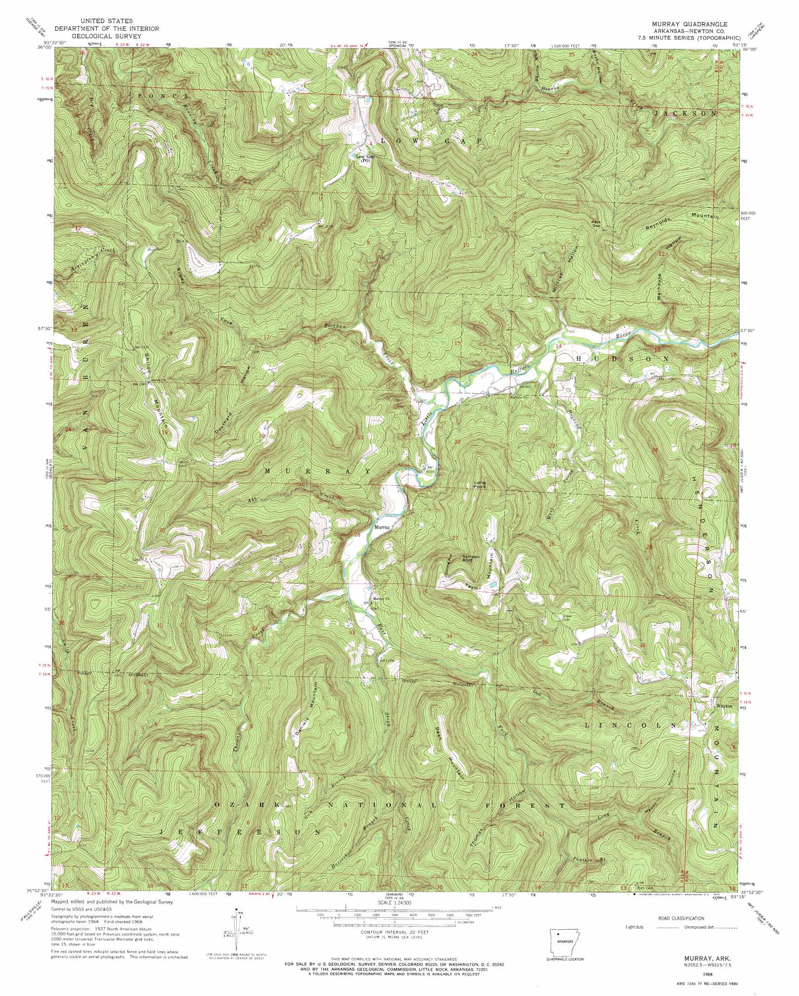
USGS Topo Quad 35093h3 - 1:24,000 scale
| Topo Map Name: | Murray |
| USGS Topo Quad ID: | 35093h3 |
| Print Size: | ca. 21 1/4" wide x 27" high |
| Southeast Coordinates: | 35.875° N latitude / 93.25° W longitude |
| Map Center Coordinates: | 35.9375° N latitude / 93.3125° W longitude |
| U.S. State: | AR |
| Filename: | o35093h3.jpg |
| Download Map JPG Image: | Murray topo map 1:24,000 scale |
| Map Type: | Topographic |
| Topo Series: | 7.5´ |
| Map Scale: | 1:24,000 |
| Source of Map Images: | United States Geological Survey (USGS) |
| Alternate Map Versions: |
Murray AR 1968, updated 1969 Download PDF Buy paper map Murray AR 1968, updated 1970 Download PDF Buy paper map Murray AR 2011 Download PDF Buy paper map Murray AR 2014 Download PDF Buy paper map |
| FStopo: | US Forest Service topo Murray is available: Download FStopo PDF Download FStopo TIF |
1:24,000 Topo Quads surrounding Murray
Marble |
Osage |
Osage Ne |
Gaither |
Harrison |
Kingston |
Osage Sw |
Ponca |
Jasper |
Hasty |
Weathers |
Boxley |
Murray |
Parthenon |
Mount Judea |
Boston |
Fallsville |
Swain |
Deer |
Lurton |
Oark |
Ozone |
Rosetta |
Fort Douglas |
Sand Gap |
> Back to 35093e1 at 1:100,000 scale
> Back to 35092a1 at 1:250,000 scale
> Back to U.S. Topo Maps home
Murray topo map: Gazetteer
Murray: Cliffs
Rainbow Bluff elevation 577m 1893′Murray: Gaps
Keys Gap elevation 497m 1630′Murray: Populated Places
Murray elevation 324m 1062′Shiloh elevation 694m 2276′
Wayton elevation 661m 2168′
Murray: Streams
Abb Creek elevation 315m 1033′Beckham Creek elevation 297m 974′
Dog Branch elevation 353m 1158′
Dry Creek elevation 439m 1440′
East Fork Little Buffalo River elevation 325m 1066′
Gum Branch elevation 387m 1269′
Hoghead Creek elevation 290m 951′
Horseshoe Branch elevation 407m 1335′
Long Branch elevation 398m 1305′
Panther Branch elevation 433m 1420′
Stepp Creek elevation 330m 1082′
Thomas Creek elevation 324m 1062′
West Prong Hoghead Creek elevation 312m 1023′
Murray: Summits
Bean Mountain elevation 621m 2037′Daniels Mountain elevation 642m 2106′
Long Point elevation 594m 1948′
Reynolds Mountain elevation 668m 2191′
Shiloh Mountain elevation 694m 2276′
Taylor Mountain elevation 661m 2168′
Murray: Valleys
Busby Hollow elevation 355m 1164′Douthard Hollow elevation 413m 1354′
Haunt Hollow elevation 477m 1564′
Lick Hollow elevation 379m 1243′
Silbey Cove elevation 415m 1361′
Spring Hollow elevation 511m 1676′
Thomas Hollow elevation 392m 1286′
Warhouse Hollow elevation 285m 935′
Wildcat Hollow elevation 319m 1046′
Murray digital topo map on disk
Buy this Murray topo map showing relief, roads, GPS coordinates and other geographical features, as a high-resolution digital map file on DVD: