O'Leary Peak Topo Map Arizona
To zoom in, hover over the map of O'Leary Peak
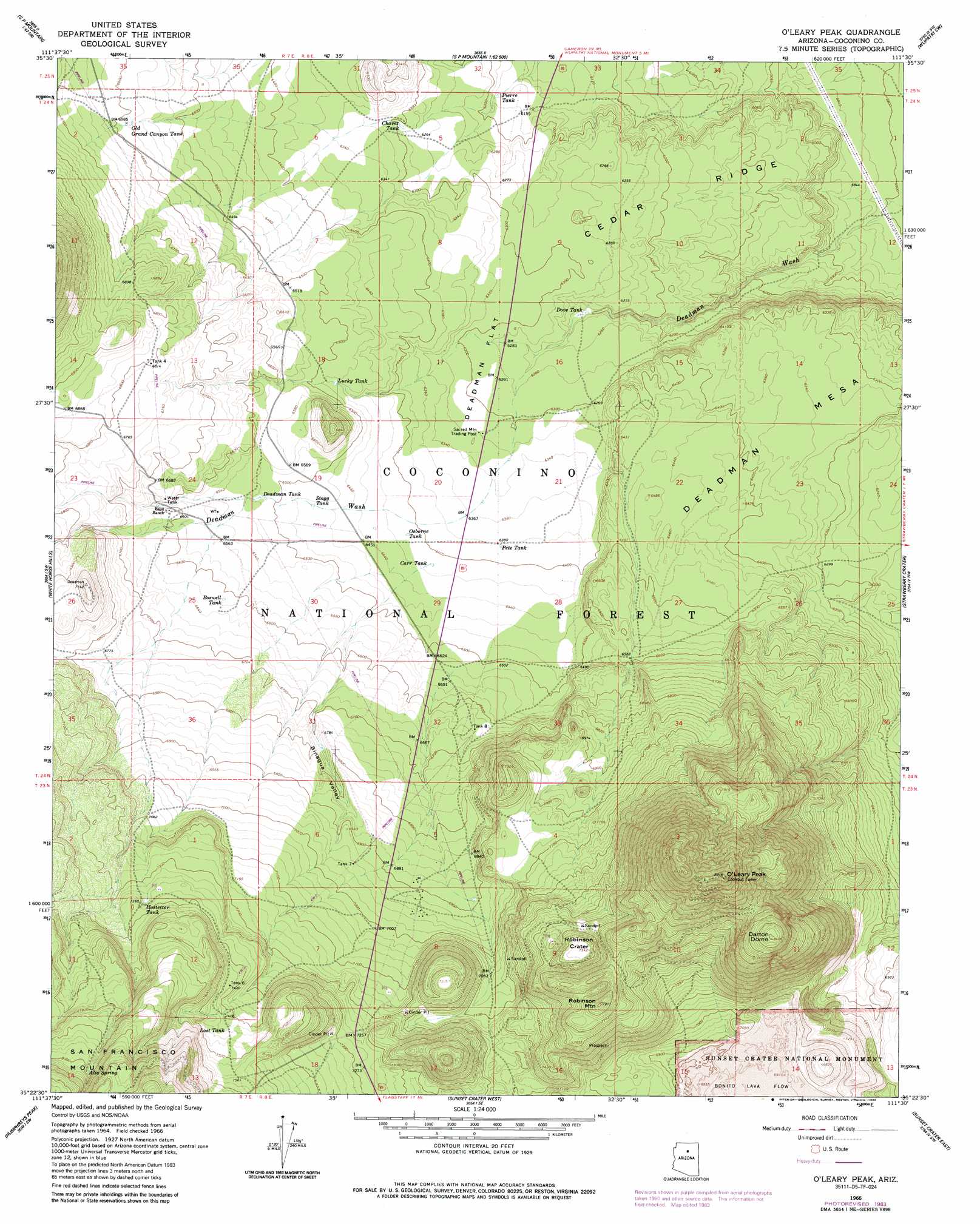
USGS Topo Quad 35111d5 - 1:24,000 scale
| Topo Map Name: | O'Leary Peak |
| USGS Topo Quad ID: | 35111d5 |
| Print Size: | ca. 21 1/4" wide x 27" high |
| Southeast Coordinates: | 35.375° N latitude / 111.5° W longitude |
| Map Center Coordinates: | 35.4375° N latitude / 111.5625° W longitude |
| U.S. State: | AZ |
| Filename: | o35111d5.jpg |
| Download Map JPG Image: | O'Leary Peak topo map 1:24,000 scale |
| Map Type: | Topographic |
| Topo Series: | 7.5´ |
| Map Scale: | 1:24,000 |
| Source of Map Images: | United States Geological Survey (USGS) |
| Alternate Map Versions: |
O'Leary Peak AZ 1966, updated 1968 Download PDF Buy paper map O'Leary Peak AZ 1966, updated 1977 Download PDF Buy paper map O'Leary Peak AZ 1966, updated 1986 Download PDF Buy paper map O'Leary Peak AZ 1983, updated 1986 Download PDF Buy paper map O'Leary Peak AZ 2011 Download PDF Buy paper map O'Leary Peak AZ 2014 Download PDF Buy paper map |
| FStopo: | US Forest Service topo O'Leary Peak is available: Download FStopo PDF Download FStopo TIF |
1:24,000 Topo Quads surrounding O'Leary Peak
Lockwood Canyon |
Additional Hill |
Campbell Francis Wash |
Gray Mountain |
Wupatki Ne |
Chapel Mountain |
S P Mountain |
East Of S P Mountain |
Wupatki Sw |
Wupatki Se |
Kendrick Peak |
White Horse Hills |
O'Leary Peak |
Strawberry Crater |
Roden Crater |
Wing Mountain |
Humphreys Peak |
Sunset Crater West |
Sunset Crater East |
Merriam Crater |
Bellemont |
Flagstaff West |
Flagstaff East |
Winona |
Angell |
> Back to 35111a1 at 1:100,000 scale
> Back to 35110a1 at 1:250,000 scale
> Back to U.S. Topo Maps home
O'Leary Peak topo map: Gazetteer
O'Leary Peak: Craters
Robinson Crater elevation 2240m 7349′O'Leary Peak: Flats
Deadman Flat elevation 1920m 6299′O'Leary Peak: Lavas
Bonita Lava Flow elevation 2125m 6971′O'Leary Peak: Reservoirs
Boswell Tank elevation 2016m 6614′Carr Tank elevation 1956m 6417′
Chavez Tank elevation 1917m 6289′
Chicos Tank elevation 2053m 6735′
Deadman Tank elevation 1985m 6512′
Dove Tank elevation 1895m 6217′
French Tank elevation 1878m 6161′
Hostetter Tank elevation 2243m 7358′
Lost Tank elevation 2268m 7440′
Lucky Tank elevation 1971m 6466′
Old Grand Canyon Tank elevation 2006m 6581′
Osborne Tank elevation 1954m 6410′
Pete Tank elevation 1946m 6384′
Pierre Tank elevation 1878m 6161′
Sawmill Tank elevation 2103m 6899′
Stagg Tank elevation 1974m 6476′
Tank Eight elevation 2029m 6656′
Tank Eight elevation 2018m 6620′
Tank Four elevation 2074m 6804′
Tank Seven elevation 2118m 6948′
Tank Six elevation 2264m 7427′
O'Leary Peak: Ridges
Bedground Ridge elevation 1976m 6482′Cedar Ridge elevation 1887m 6190′
O'Leary Peak: Springs
Alto Spring elevation 2433m 7982′O'Leary Peak: Summits
Darton Dome elevation 2563m 8408′Deadman Mesa elevation 1976m 6482′
O'Leary Peak elevation 2704m 8871′
Robinson Mountain elevation 2406m 7893′
O'Leary Peak: Valleys
Bear Jaw Canyon elevation 2140m 7020′Medicine Valley elevation 2209m 7247′
Sinagua Valley elevation 1991m 6532′
O'Leary Peak digital topo map on disk
Buy this O'Leary Peak topo map showing relief, roads, GPS coordinates and other geographical features, as a high-resolution digital map file on DVD: