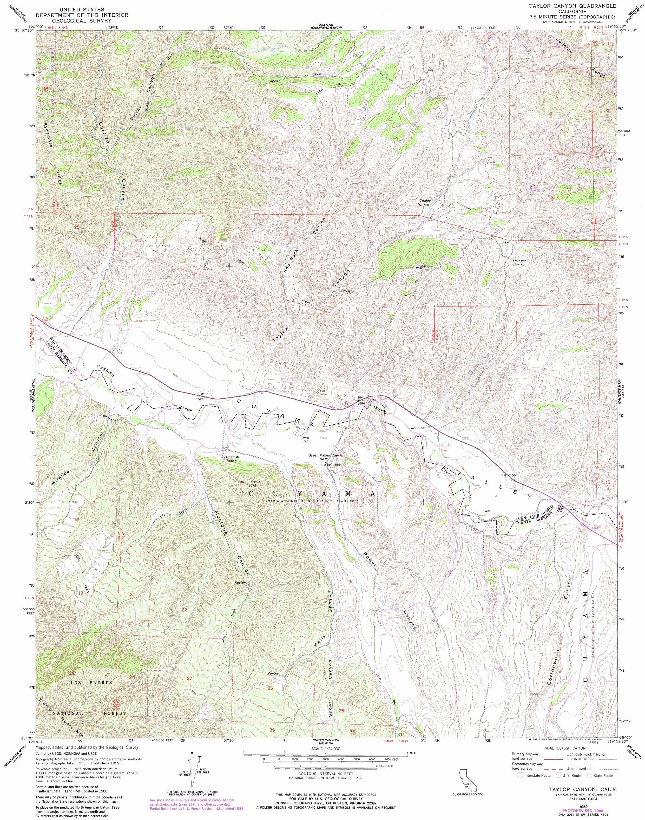
Taylor Canyon Topo Map California
To zoom in, hover over the map of Taylor Canyon
USGS Topo Quad 35119a8 - 1:24,000 scale
| Topo Map Name: | Taylor Canyon |
| USGS Topo Quad ID: | 35119a8 |
| Print Size: | ca. 21 1/4" wide x 27" high |
| Southeast Coordinates: | 35° N latitude / 119.875° W longitude |
| Map Center Coordinates: | 35.0625° N latitude / 119.9375° W longitude |
| U.S. State: | CA |
| Filename: | o35119a8.jpg |
| Download Map JPG Image: | Taylor Canyon topo map 1:24,000 scale |
| Map Type: | Topographic |
| Topo Series: | 7.5´ |
| Map Scale: | 1:24,000 |
| Source of Map Images: | United States Geological Survey (USGS) |
| Alternate Map Versions: |
Taylor Canyon CA 1959, updated 1961 Download PDF Buy paper map Taylor Canyon CA 1959, updated 1961 Download PDF Buy paper map Taylor Canyon CA 1959, updated 1989 Download PDF Buy paper map Taylor Canyon CA 1995, updated 2000 Download PDF Buy paper map Taylor Canyon CA 2012 Download PDF Buy paper map Taylor Canyon CA 2015 Download PDF Buy paper map |
| FStopo: | US Forest Service topo Taylor Canyon is available: Download FStopo PDF Download FStopo TIF |
1:24,000 Topo Quads surrounding Taylor Canyon
La Panza |
California Valley |
Simmler |
Mckittrick Summit |
Reward |
Los Machos Hills |
Branch Mountain |
Chimineas Ranch |
Painted Rock |
Panorama Hills |
Chimney Canyon |
Miranda Pine Mountain |
Taylor Canyon |
Caliente Mountain |
Wells Ranch |
Tepusquet Canyon |
Manzanita Mountain |
Bates Canyon |
Peak Mountain |
New Cuyama |
Foxen Canyon |
Zaca Lake |
Bald Mountain |
Hurricane Deck |
Salisbury Potrero |
> Back to 35119a1 at 1:100,000 scale
> Back to 35118a1 at 1:250,000 scale
> Back to U.S. Topo Maps home
Taylor Canyon topo map: Gazetteer
Taylor Canyon: Springs
Pearson Spring elevation 682m 2237′Taylor Spring elevation 652m 2139′
Taylor Canyon: Valleys
Carrizo Canyon elevation 428m 1404′Cottonwood Canyon elevation 499m 1637′
Kelly Canyon elevation 468m 1535′
Kelsey Canyon elevation 512m 1679′
Miranda Canyon elevation 439m 1440′
Mustang Canyon elevation 452m 1482′
Powell Canyon elevation 474m 1555′
Red Rock Canyon elevation 528m 1732′
Saltos Canyon elevation 528m 1732′
Spoor Canyon elevation 559m 1833′
Taylor Canyon elevation 475m 1558′
Taylor Canyon digital topo map on disk
Buy this Taylor Canyon topo map showing relief, roads, GPS coordinates and other geographical features, as a high-resolution digital map file on DVD:
Southern Sierra Nevada, California & Southern Nevada
Buy digital topo maps: Southern Sierra Nevada, California & Southern Nevada