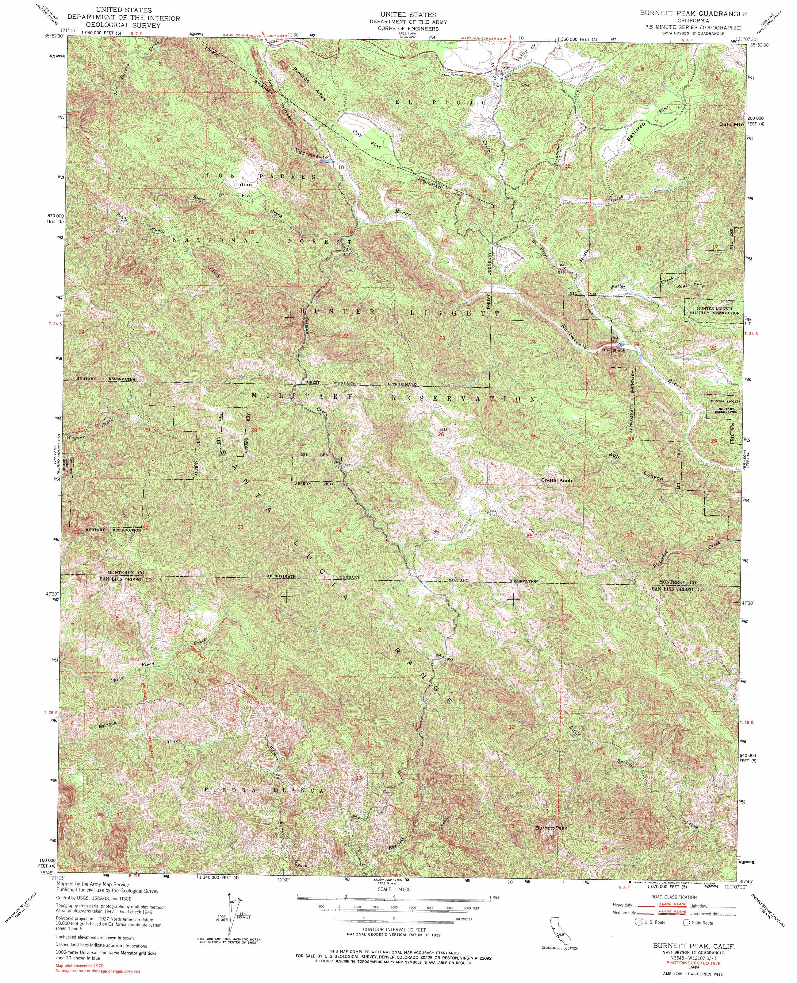
Burnett Peak Topo Map California
To zoom in, hover over the map of Burnett Peak
USGS Topo Quad 35121g2 - 1:24,000 scale
| Topo Map Name: | Burnett Peak |
| USGS Topo Quad ID: | 35121g2 |
| Print Size: | ca. 21 1/4" wide x 27" high |
| Southeast Coordinates: | 35.75° N latitude / 121.125° W longitude |
| Map Center Coordinates: | 35.8125° N latitude / 121.1875° W longitude |
| U.S. State: | CA |
| Filename: | o35121g2.jpg |
| Download Map JPG Image: | Burnett Peak topo map 1:24,000 scale |
| Map Type: | Topographic |
| Topo Series: | 7.5´ |
| Map Scale: | 1:24,000 |
| Source of Map Images: | United States Geological Survey (USGS) |
| Alternate Map Versions: |
Burnett Peak CA 1949, updated 1953 Download PDF Buy paper map Burnett Peak CA 1949, updated 1965 Download PDF Buy paper map Burnett Peak CA 1949, updated 1965 Download PDF Buy paper map Burnett Peak CA 1949, updated 1979 Download PDF Buy paper map Burnett Peak CA 1949, updated 1979 Download PDF Buy paper map Burnett Peak CA 1995, updated 2000 Download PDF Buy paper map Burnett Peak CA 2012 Download PDF Buy paper map Burnett Peak CA 2015 Download PDF Buy paper map |
| FStopo: | US Forest Service topo Burnett Peak is available: Download FStopo PDF Download FStopo TIF |
1:24,000 Topo Quads surrounding Burnett Peak
Cone Peak |
Bear Canyon |
Cosio Knob |
Espinosa Canyon |
San Ardo |
Cape San Martin |
Alder Peak |
Jolon |
Williams Hill |
Hames Valley |
Villa Creek |
Burro Mountain |
Burnett Peak |
Bryson |
Tierra Redondo Mountain |
Piedras Blancas |
San Simeon |
Pebblestone Shut-In |
Lime Mountain |
|
Pico Creek |
Cambria |
Cypress Mountain |
> Back to 35121e1 at 1:100,000 scale
> Back to 35120a1 at 1:250,000 scale
> Back to U.S. Topo Maps home
Burnett Peak topo map: Gazetteer
Burnett Peak: Dams
El Piojo Reservoir Dam elevation 330m 1082′Sycamore Reservoir Dam elevation 341m 1118′
Burnett Peak: Flats
Beartrap Flat elevation 394m 1292′Italian Flat elevation 426m 1397′
Little Oak Flat elevation 305m 1000′
Oak Flat elevation 345m 1131′
Burnett Peak: Mines
Quicksilver Mine elevation 347m 1138′Burnett Peak: Ridges
Piedras Altas elevation 369m 1210′The Pallsades elevation 334m 1095′
Burnett Peak: Streams
El Piojo Creek elevation 276m 905′Los Burros Creek elevation 319m 1046′
Pozo Hondo Creek elevation 384m 1259′
Salmon Creek elevation 293m 961′
South Fork Waller Creek elevation 300m 984′
Steve Creek elevation 342m 1122′
Sycamore Creek elevation 288m 944′
Twin Valley Creek elevation 322m 1056′
Waller Creek elevation 279m 915′
Burnett Peak: Summits
Burnett Peak elevation 919m 3015′Crystal Knob elevation 751m 2463′
Burnett Peak: Valleys
Bull Canyon elevation 270m 885′The Shut-in elevation 278m 912′
Burnett Peak digital topo map on disk
Buy this Burnett Peak topo map showing relief, roads, GPS coordinates and other geographical features, as a high-resolution digital map file on DVD: