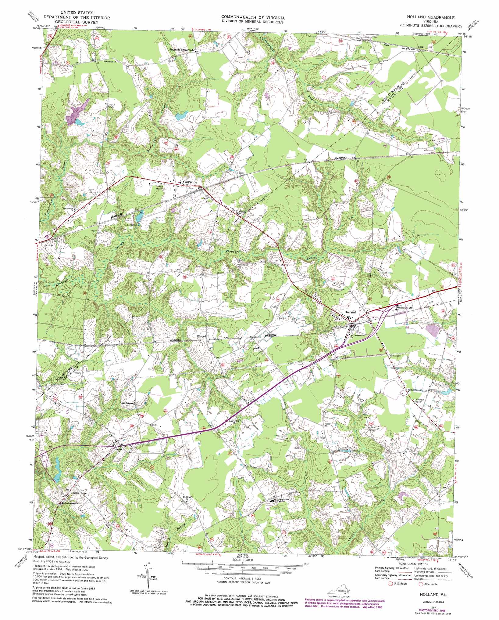
Holland Topo Map Virginia
To zoom in, hover over the map of Holland
USGS Topo Quad 36076f7 - 1:24,000 scale
| Topo Map Name: | Holland |
| USGS Topo Quad ID: | 36076f7 |
| Print Size: | ca. 21 1/4" wide x 27" high |
| Southeast Coordinates: | 36.625° N latitude / 76.75° W longitude |
| Map Center Coordinates: | 36.6875° N latitude / 76.8125° W longitude |
| U.S. State: | VA |
| Filename: | o36076f7.jpg |
| Download Map JPG Image: | Holland topo map 1:24,000 scale |
| Map Type: | Topographic |
| Topo Series: | 7.5´ |
| Map Scale: | 1:24,000 |
| Source of Map Images: | United States Geological Survey (USGS) |
| Alternate Map Versions: |
Holland VA 1967, updated 1969 Download PDF Buy paper map Holland VA 1967, updated 1980 Download PDF Buy paper map Holland VA 1967, updated 1986 Download PDF Buy paper map Holland VA 2010 Download PDF Buy paper map Holland VA 2013 Download PDF Buy paper map Holland VA 2016 Download PDF Buy paper map |
1:24,000 Topo Quads surrounding Holland
Manry |
Ivor |
Raynor |
Smithfield |
Benns Church |
Vicksville |
Sedley |
Zuni |
Windsor |
Chuckatuck |
Courtland |
Franklin |
Holland |
Buckhorn |
Suffolk |
Sunbeam |
Riverdale |
Gates |
Whaleyville |
Corapeake |
Murfreesboro |
Winton |
Gatesville |
Merchants Millpond |
Sunbury |
> Back to 36076e1 at 1:100,000 scale
> Back to 36076a1 at 1:250,000 scale
> Back to U.S. Topo Maps home
Holland topo map: Gazetteer
Holland: Airports
Brandywyne Farms Airport elevation 19m 62′Holland: Dams
Alemar Dam elevation 17m 55′Holland: Populated Places
Beales Corner elevation 19m 62′Boaz elevation 25m 82′
Carrsville elevation 21m 68′
Elwood elevation 20m 65′
Holland elevation 25m 82′
Oak Grove elevation 23m 75′
Pineville elevation 20m 65′
Holland: Post Offices
Carrsville Post Office elevation 20m 65′Holland Post Office elevation 25m 82′
Holland: Reservoirs
Alemar Pond elevation 17m 55′Holland Millpond (historical) elevation 11m 36′
Holland: Swamps
Kingsale Swamp elevation 9m 29′Holland digital topo map on disk
Buy this Holland topo map showing relief, roads, GPS coordinates and other geographical features, as a high-resolution digital map file on DVD:
Atlantic Coast (NY, NJ, PA, DE, MD, VA, NC)
Buy digital topo maps: Atlantic Coast (NY, NJ, PA, DE, MD, VA, NC)
 map DVD")